
Geographic Region: USA-NORTH DAKOTA
Feature: PEACE GARDEN
|
Geographic Region: USA-NORTH DAKOTA Feature: PEACE GARDEN |
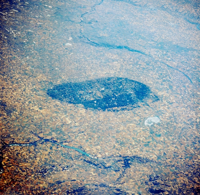 |
| STS028-076-003 International Peace Garden, Manitoba, Canada August 1989 The roughly oval-shaped, large dark feature in the center of the picture is the International Peace Garden. This international park (Canada-U.S.) straddles the 49th parallel with the larger area located in northern North Dakota and the smaller area located in southwestern Manitoba. The Peace Garden is a slightly elevated, forested region that has many small lakes (not visible on this image) scattered throughout the boundaries of the park. The largest gray -looking feature north of the Peace Garden is Whitewater Lake. While most of the terrain is covered by large wheat fields, the Pembina River, including Pelican Lake is visible on the Canadian side of the border and the Souris River channel (thin dark linear feature southwest of the Peace Garden) can be traced across the North Dakota landscape. |
| Images: | All Available Images Low-Resolution 434k |
|
| Mission: | STS028 |
|
| Roll - Frame: | 76 - 3 |
|
| Geographical Name: | USA-NORTH DAKOTA |
|
| Features: | PEACE GARDEN |
|
| Center Lat x Lon: | 49.0N x 100W |
|
| Film Exposure: | N | N=Normal exposure, U=Under exposed, O=Over exposed, F=out of Focus |
| Percentage of Cloud Cover-CLDP: | 0 |
|
| Camera:: | HB |
|
| Camera Tilt: | HO | LO=Low Oblique, HO=High Oblique, NV=Near Vertical |
| Camera Focal Length: | 250 |
|
| Nadir to Photo Center Direction: | SW | The direction from the nadir to the center point, N=North, S=South, E=East, W=West |
| Stereo?: | N | Y=Yes there is an adjacent picture of the same area, N=No there isn't |
| Orbit Number: | 6 |
|
| Date: | 19890808 | YYYYMMDD |
| Time: | 203331 | GMT HHMMSS |
| Nadir Lat: | 52.0N |
Latitude of suborbital point of spacecraft |
| Nadir Lon: | 96.4W |
Longitude of suborbital point of spacecraft |
| Sun Azimuth: | 226 | Clockwise angle in degrees from north to the sun measured at the nadir point |
| Space Craft Altitude: | 163 | nautical miles |
| Sun Elevation: | 47 | Angle in degrees between the horizon and the sun, measured at the nadir point |
| Land Views: | PLAIN |
|
| Water Views: | LAKE, RIVER |
|
| Atmosphere Views: | |
|
| Man Made Views: | AGRICULTURE |
|
| City Views: | |
|
Photo is not associated with any sequences | ||
| NASA Home Page |
JSC Home Page |
JSC Digital Image Collection |
Earth Science & Remote Sensing |
|
This service is provided by the International Space Station program and the JSC Earth Science & Remote Sensing Unit, ARES Division, Exploration Integration Science Directorate.

|