Geographic Region: USA-ALASKA
Feature: REVILLAGIGEDO ISLAND
|
Geographic Region: USA-ALASKA Feature: REVILLAGIGEDO ISLAND |
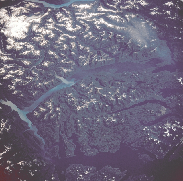 |
| STS028-073-039 Revillagigedo Island, Alaska, U.S.A August 1989 Part of the southern Alaskan panhandle is discernible in this photograph. Snow accentuates the ridge lines and peaks in the higher elevations. A small glacier can be seen in the lower-right corner. The light blue water of the Behm Canal, which separates Revillagigedo Island from the mainland of North America, is created by "rock-flour" sediment that is the result of glacial erosion. The Portland Canal, visible at the bottom of the photograph, forms part of the U.S.-Canada border. |
| Images: | All Available Images Low-Resolution 343k |
|
| Mission: | STS028 |
|
| Roll - Frame: | 73 - 39 |
|
| Geographical Name: | USA-ALASKA |
|
| Features: | REVILLAGIGEDO ISLAND |
|
| Center Lat x Lon: | 55.5N x 131W |
|
| Film Exposure: | N | N=Normal exposure, U=Under exposed, O=Over exposed, F=out of Focus |
| Percentage of Cloud Cover-CLDP: | 5 |
|
| Camera:: | HB |
|
| Camera Tilt: | LO | LO=Low Oblique, HO=High Oblique, NV=Near Vertical |
| Camera Focal Length: | 250 |
|
| Nadir to Photo Center Direction: | E | The direction from the nadir to the center point, N=North, S=South, E=East, W=West |
| Stereo?: | N | Y=Yes there is an adjacent picture of the same area, N=No there isn't |
| Orbit Number: | 54 |
|
| Date: | 19890811 | YYYYMMDD |
| Time: | 205506 | GMT HHMMSS |
| Nadir Lat: | 55.8N |
Latitude of suborbital point of spacecraft |
| Nadir Lon: | 135.1W |
Longitude of suborbital point of spacecraft |
| Sun Azimuth: | 177 | Clockwise angle in degrees from north to the sun measured at the nadir point |
| Space Craft Altitude: | 162 | nautical miles |
| Sun Elevation: | 49 | Angle in degrees between the horizon and the sun, measured at the nadir point |
| Land Views: | ISLAND, GLACIER |
|
| Water Views: | CANAL |
|
| Atmosphere Views: | |
|
| Man Made Views: | |
|
| City Views: | |
|
Photo is not associated with any sequences | ||
| NASA Home Page |
JSC Home Page |
JSC Digital Image Collection |
Earth Science & Remote Sensing |
|
This service is provided by the International Space Station program and the JSC Earth Science & Remote Sensing Unit, ARES Division, Exploration Integration Science Directorate.

|