Geographic Region: NEW ZEALAND
Feature: NORTH I,COOK STR,L. TAUPO
|
Geographic Region: NEW ZEALAND Feature: NORTH I,COOK STR,L. TAUPO |
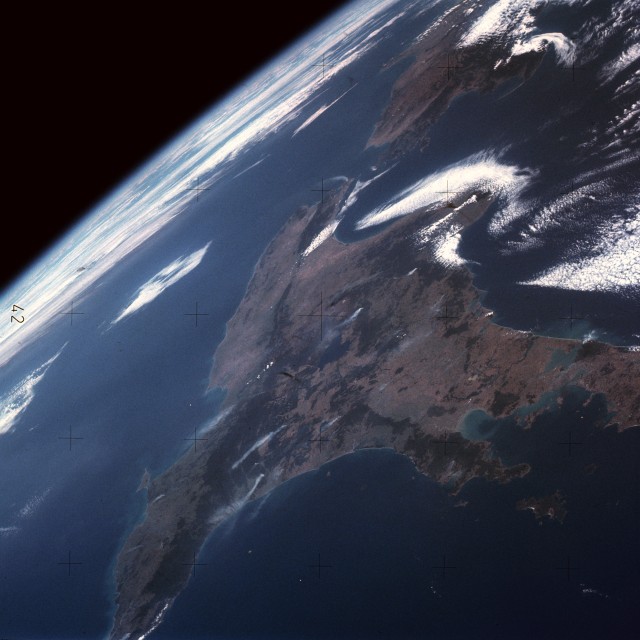 |
| SL4-142-4592 North Island, New Zealand 1973 Smaller but more populous North Island is separated from South Island (southwest part of photograph) by Cook Strait in this high-oblique, south-looking photograph. North Island consists of hilly, forested land with several disconnected ranges separated by small plains and basins. Occupying an unstable section of the Earth's crust along the "Pacific Rim of Fire" where mountain building and other crustal disturbances occur, North Island has a line of active volcanoes and a multitude of geysers, hot springs, fumaroles, and geothermal steam vents across the central and western island. The northern portion of the island, where the major city of Auckland is located, is characterized by a more gentle terrain with alternating plains and coastal beaches. The island has an abundance of excellent harbors. North Island contains most of New Zealand's dairy and wine industries, along with oil, iron, and coal processing. The island, home of New Zealand's world-famous kiwi bird, has no land snakes of any kind. |
| Images: | All Available Images Low-Resolution 81k |
|
| Mission: | SL4 |
|
| Roll - Frame: | 142 - 4592 |
|
| Geographical Name: | NEW ZEALAND |
|
| Features: | NORTH I,COOK STR,L. TAUPO |
|
| Center Lat x Lon: | 39S x 176.0E |
|
| Film Exposure: | N | N=Normal exposure, U=Under exposed, O=Over exposed, F=out of Focus |
| Percentage of Cloud Cover-CLDP: | 35 |
|
| Camera:: | HB |
|
| Camera Tilt: | HO | LO=Low Oblique, HO=High Oblique, NV=Near Vertical |
| Camera Focal Length: | 100 |
|
| Nadir to Photo Center Direction: | The direction from the nadir to the center point, N=North, S=South, E=East, W=West |
|
| Stereo?: | N | Y=Yes there is an adjacent picture of the same area, N=No there isn't |
| Orbit Number: | |
|
| Date: | YYYYMMDD |
|
| Time: | GMT HHMMSS |
|
| Nadir Lat: | N |
Latitude of suborbital point of spacecraft |
| Nadir Lon: | E |
Longitude of suborbital point of spacecraft |
| Sun Azimuth: | Clockwise angle in degrees from north to the sun measured at the nadir point |
|
| Space Craft Altitude: | nautical miles |
|
| Sun Elevation: | Angle in degrees between the horizon and the sun, measured at the nadir point |
|
| Land Views: | FOREST, ISLAND, CAPE |
|
| Water Views: | BAY, STRAIT, LAKE |
|
| Atmosphere Views: | |
|
| Man Made Views: | |
|
| City Views: | |
|
Photo is not associated with any sequences | ||
| NASA Home Page |
JSC Home Page |
JSC Digital Image Collection |
Earth Science & Remote Sensing |
|
This service is provided by the International Space Station program and the JSC Earth Science & Remote Sensing Unit, ARES Division, Exploration Integration Science Directorate.

|