
Geographic Region: USA-WISCONSIN
Feature: ROCK RIVER, CITIES
|
Geographic Region: USA-WISCONSIN Feature: ROCK RIVER, CITIES |
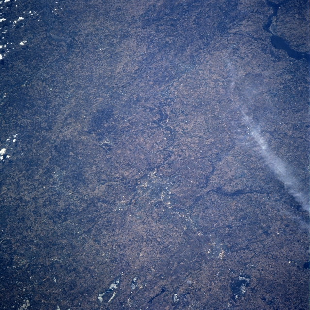 |
| NM23-746-713 Rockford, Illinois Spring, 1997 Numerous agricultural field patterns are visible in this southwest-looking view. The terrain of this portion of Illinois is gently rolling to flat. The major crops grown are corn and soybeans. Just below the center portion of the image, is the city of Rockford. Located on the Rock River, Rockford is the trade, processing, and shipping hub of this extensive agricultural region. The city was founded in 1834 on the site of a battlefield during the Black Hawk Indian War. |
| Images: | All Available Images Low-Resolution 391k |
|
| Mission: | NM23 |
|
| Roll - Frame: | 746 - 713 |
|
| Geographical Name: | USA-WISCONSIN |
|
| Features: | ROCK RIVER, CITIES |
|
| Center Lat x Lon: | 42.5N x 89W |
|
| Film Exposure: | N | N=Normal exposure, U=Under exposed, O=Over exposed, F=out of Focus |
| Percentage of Cloud Cover-CLDP: | 5 |
|
| Camera:: | HB |
|
| Camera Tilt: | LO | LO=Low Oblique, HO=High Oblique, NV=Near Vertical |
| Camera Focal Length: | 250 |
|
| Nadir to Photo Center Direction: | SW | The direction from the nadir to the center point, N=North, S=South, E=East, W=West |
| Stereo?: | Y | Y=Yes there is an adjacent picture of the same area, N=No there isn't |
| Orbit Number: | 999 |
|
| Date: | 19970425 | YYYYMMDD |
| Time: | 182433 | GMT HHMMSS |
| Nadir Lat: | 47.2N |
Latitude of suborbital point of spacecraft |
| Nadir Lon: | 82.6W |
Longitude of suborbital point of spacecraft |
| Sun Azimuth: | 204 | Clockwise angle in degrees from north to the sun measured at the nadir point |
| Space Craft Altitude: | 209 | nautical miles |
| Sun Elevation: | 54 | Angle in degrees between the horizon and the sun, measured at the nadir point |
| Land Views: | PLAIN |
|
| Water Views: | RIVER |
|
| Atmosphere Views: | |
|
| Man Made Views: | AGRICULTURE |
|
| City Views: | |
|
Photo is not associated with any sequences | ||
| NASA Home Page |
JSC Home Page |
JSC Digital Image Collection |
Earth Science & Remote Sensing |
|
This service is provided by the International Space Station program and the JSC Earth Science & Remote Sensing Unit, ARES Division, Exploration Integration Science Directorate.

|