Geographic Region: INDIA
Feature: BRAHMAPUTRA RIVER
|
Geographic Region: INDIA Feature: BRAHMAPUTRA RIVER |
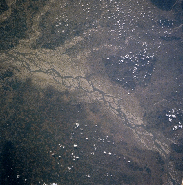 |
| NM23-735-942 Brahmaputra River, India Winter-Spring 1997 The braided, multiple channels of the Brahmaputra River of northeast India and northern Bangladesh makes a significant course change (flowing west-bottom right to flowing south-left middle), as the river skirts the northwest end of the Khasi Hills (darker area, lower left). The image was acquired during the post-summer wet monsoon period, reflecting a river that has not received much runoff from the surrounding terrain for several months. The extensive floodplain, the braided channels, and the large, light-colored sand bars are all indications of low water conditions in the river. Even the tributary streams (meandering, thin dark lines) that drain the northern part of the basin from the front range of the Himalayas show extensive sandbars. This is another indication that runoff from the hills and mountains in Northeast India and Bhutan is minimal at this time of year. Darker areas are more heavily vegetated. A small piece of the Space Shuttle can be seen in the lower right corner of the image. |
| Images: | All Available Images Low-Resolution 373k |
|
| Mission: | NM23 |
|
| Roll - Frame: | 735 - 942 |
|
| Geographical Name: | INDIA |
|
| Features: | BRAHMAPUTRA RIVER |
|
| Center Lat x Lon: | 26.0N x 90.5E |
|
| Film Exposure: | N | N=Normal exposure, U=Under exposed, O=Over exposed, F=out of Focus |
| Percentage of Cloud Cover-CLDP: | 10 |
|
| Camera:: | HB |
|
| Camera Tilt: | LO | LO=Low Oblique, HO=High Oblique, NV=Near Vertical |
| Camera Focal Length: | 250 |
|
| Nadir to Photo Center Direction: | W | The direction from the nadir to the center point, N=North, S=South, E=East, W=West |
| Stereo?: | Y | Y=Yes there is an adjacent picture of the same area, N=No there isn't |
| Orbit Number: | 999 |
|
| Date: | 19970418 | YYYYMMDD |
| Time: | 064904 | GMT HHMMSS |
| Nadir Lat: | 17.1N |
Latitude of suborbital point of spacecraft |
| Nadir Lon: | 116W |
Longitude of suborbital point of spacecraft |
| Sun Azimuth: | 333 | Clockwise angle in degrees from north to the sun measured at the nadir point |
| Space Craft Altitude: | 211 | nautical miles |
| Sun Elevation: | -59 | Angle in degrees between the horizon and the sun, measured at the nadir point |
| Land Views: | HILL, PLAIN |
|
| Water Views: | RIVER, CHANNEL |
|
| Atmosphere Views: | |
|
| Man Made Views: | |
|
| City Views: | |
|
Photo is not associated with any sequences | ||
| NASA Home Page |
JSC Home Page |
JSC Digital Image Collection |
Earth Science & Remote Sensing |
|
This service is provided by the International Space Station program and the JSC Earth Science & Remote Sensing Unit, ARES Division, Exploration Integration Science Directorate.

|