Geographic Region: ARGENTINA
Feature: RIO PARANA, AGRICULTURE
|
Geographic Region: ARGENTINA Feature: RIO PARANA, AGRICULTURE |
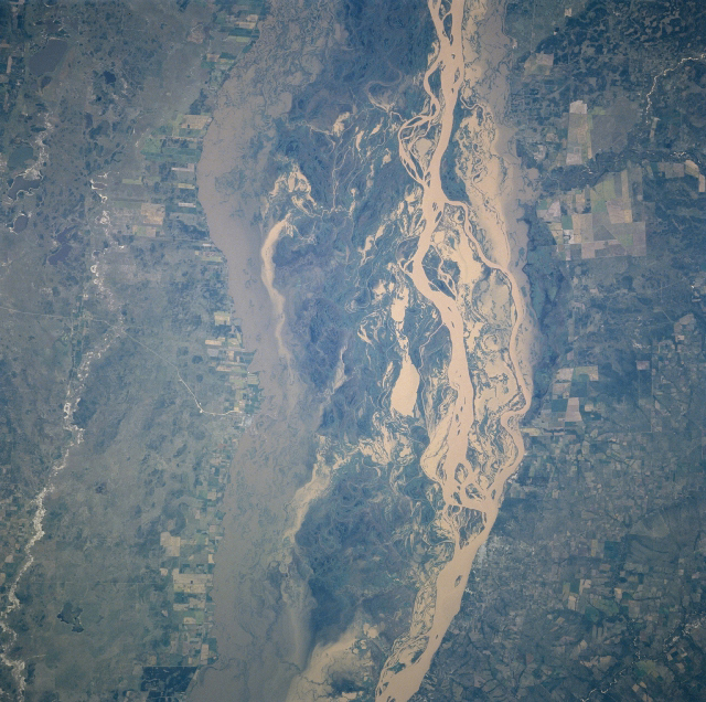 |
| NM23-719-444 Rio Parana, Argentina Winter/Spring 1997 The east-west boundaries of the broad floodplain of the south flowing Rio Parana can be discerned on this near vertical view of the river in northeast Argentina. The major braided channels within the floodplain present a whiter-looking surface than the less turbulent, muddy water along the edges of the floodplain. The thin, light-colored linear features on the image are roads and the angular-looking field patterns on either side of the river's floodplain are cultivated fields used for agriculture. (Refer to NM23-719-442, NM23-719-446, and NM23-719-448 for other images and information about this section of the Rio Parana in northeast Argentina). |
| Images: | All Available Images Low-Resolution 471k |
|
| Mission: | NM23 |
|
| Roll - Frame: | 719 - 444 |
|
| Geographical Name: | ARGENTINA |
|
| Features: | RIO PARANA, AGRICULTURE |
|
| Center Lat x Lon: | 30.5S x 59.5W |
|
| Film Exposure: | N | N=Normal exposure, U=Under exposed, O=Over exposed, F=out of Focus |
| Percentage of Cloud Cover-CLDP: | 0 |
|
| Camera:: | HB |
|
| Camera Tilt: | LO | LO=Low Oblique, HO=High Oblique, NV=Near Vertical |
| Camera Focal Length: | 100 |
|
| Nadir to Photo Center Direction: | SE | The direction from the nadir to the center point, N=North, S=South, E=East, W=West |
| Stereo?: | Y | Y=Yes there is an adjacent picture of the same area, N=No there isn't |
| Orbit Number: | |
|
| Date: | 19970328 | YYYYMMDD |
| Time: | GMT HHMMSS |
|
| Nadir Lat: | N |
Latitude of suborbital point of spacecraft |
| Nadir Lon: | E |
Longitude of suborbital point of spacecraft |
| Sun Azimuth: | Clockwise angle in degrees from north to the sun measured at the nadir point |
|
| Space Craft Altitude: | nautical miles |
|
| Sun Elevation: | Angle in degrees between the horizon and the sun, measured at the nadir point |
|
| Land Views: | FLOOD PLAIN |
|
| Water Views: | RIVER, SEDIMENT |
|
| Atmosphere Views: | |
|
| Man Made Views: | AGRICULTURE |
|
| City Views: | |
|
Photo is not associated with any sequences | ||
| NASA Home Page |
JSC Home Page |
JSC Digital Image Collection |
Earth Science & Remote Sensing |
|
This service is provided by the International Space Station program and the JSC Earth Science & Remote Sensing Unit, ARES Division, Exploration Integration Science Directorate.

|