Geographic Region: SAUDI ARABIA
Feature: PIVOT IRRIGATION, DUNES
|
Geographic Region: SAUDI ARABIA Feature: PIVOT IRRIGATION, DUNES |
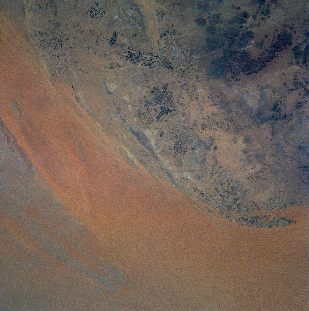 |
| NM22-726-022 An Nafud, Saudi Arabia Fall-Winter 1996 The reddish-orange desert sands of the eastern An Nafud (red desert) of north central Saudi Arabia is visible along the top of the image. A corridor of sand dunes and sand ridges, known as the Ad-Dahna, is evident as a northwest-southeast extension of the An Nafud. This corridor constitutes a sandy plain that enhances the movement of wind blown sand from the An Nafud to the great Rub'al-Khali (Empty Quarter) of southern Saudi Arabia. Literally hundreds of circular features are observed along the western margin of the Ad-Dahna. These are center pivot irrigation fields where a variety of agricultural crops, mainly wheat and cereal grains, are being grown in this arid environment. Each circle is about half a mile in diameter. In spite of extremes in aridity and temperatures, the Saudi farmers have successfully turned their desert into productive farmlands, at the expense of depleting ground water resources. Since there are virtually no permanent surface streams (only wadis) in Saudi Arabia, farmers must use well water. With their finite supply of well water, the Saudi's have been developing desalinization techniques, so that when ground water supplies are exhausted, desalinized seawater will be available to continue the extensive farming operation that is now in place. The darker looking landscape (lower left) is more rugged higher elevations that include the Aja (granites) and Salma (basalts) Mountains. |
| Images: | All Available Images Low-Resolution 370k |
|
| Mission: | NM22 |
|
| Roll - Frame: | 726 - 22 |
|
| Geographical Name: | SAUDI ARABIA |
|
| Features: | PIVOT IRRIGATION, DUNES |
|
| Center Lat x Lon: | 28.0N x 42.5E |
|
| Film Exposure: | N | N=Normal exposure, U=Under exposed, O=Over exposed, F=out of Focus |
| Percentage of Cloud Cover-CLDP: | 0 |
|
| Camera:: | HB |
|
| Camera Tilt: | LO | LO=Low Oblique, HO=High Oblique, NV=Near Vertical |
| Camera Focal Length: | 100 |
|
| Nadir to Photo Center Direction: | SW | The direction from the nadir to the center point, N=North, S=South, E=East, W=West |
| Stereo?: | Y | Y=Yes there is an adjacent picture of the same area, N=No there isn't |
| Orbit Number: | 999 |
|
| Date: | 19961026 | YYYYMMDD |
| Time: | 083925 | GMT HHMMSS |
| Nadir Lat: | 35.5N |
Latitude of suborbital point of spacecraft |
| Nadir Lon: | 51.6E |
Longitude of suborbital point of spacecraft |
| Sun Azimuth: | 187 | Clockwise angle in degrees from north to the sun measured at the nadir point |
| Space Craft Altitude: | 202 | nautical miles |
| Sun Elevation: | 42 | Angle in degrees between the horizon and the sun, measured at the nadir point |
| Land Views: | DESERT, DUNE |
|
| Water Views: | |
|
| Atmosphere Views: | |
|
| Man Made Views: | AGRICULTURE |
|
| City Views: | |
|
Photo is not associated with any sequences | ||
| NASA Home Page |
JSC Home Page |
JSC Digital Image Collection |
Earth Science & Remote Sensing |
|
This service is provided by the International Space Station program and the JSC Earth Science & Remote Sensing Unit, ARES Division, Exploration Integration Science Directorate.

|