
Geographic Region: USA-IOWA
Feature: ROCK I. & MISSISSIPPI R.
|
Geographic Region: USA-IOWA Feature: ROCK I. & MISSISSIPPI R. |
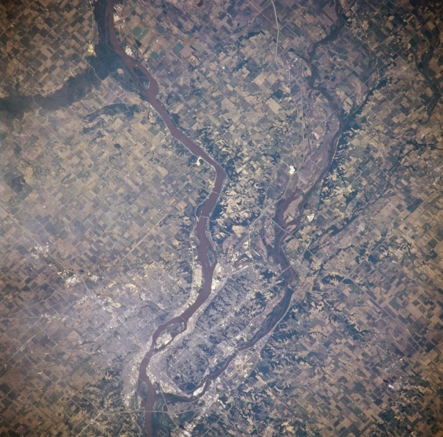 |
| NM21-765-041 Rock Island and Moline, Illinois; Davenport, Iowa, U.S.A. Winter 1995-1996 The quad cities of Rock Island and Moline, Illinois, and Davenport, Iowa, are visible in this east-northeast-looking, low-oblique photograph. Rock Island, a major transportation and commercial hub, sits in the curve of the U-shaped junction of the Mississippi and Rock Rivers. Moline is a major transportation and industrial center and a major producer of farm machinery. The sediment-filled Mississippi River is joined by the Rock River just south of Moline and by the Wapsipinicon River north of the quad cities. Agricultural field patterns dominate the landscape. On the northern bank of the Mississippi River is Davenport, site of the first railroad to span the Mississippi and an important rail, commercial, and industrial center. |
| Images: | All Available Images Low-Resolution 378k |
|
| Mission: | NM21 |
|
| Roll - Frame: | 765 - 41 |
|
| Geographical Name: | USA-IOWA |
|
| Features: | ROCK I. & MISSISSIPPI R. |
|
| Center Lat x Lon: | 41.5N x 90.5W |
|
| Film Exposure: | N | N=Normal exposure, U=Under exposed, O=Over exposed, F=out of Focus |
| Percentage of Cloud Cover-CLDP: | 5 |
|
| Camera:: | HB |
|
| Camera Tilt: | 13 | LO=Low Oblique, HO=High Oblique, NV=Near Vertical |
| Camera Focal Length: | 250 |
|
| Nadir to Photo Center Direction: | N | The direction from the nadir to the center point, N=North, S=South, E=East, W=West |
| Stereo?: | Y | Y=Yes there is an adjacent picture of the same area, N=No there isn't |
| Orbit Number: | 999 |
|
| Date: | 19960703 | YYYYMMDD |
| Time: | 165153 | GMT HHMMSS |
| Nadir Lat: | 40.7N |
Latitude of suborbital point of spacecraft |
| Nadir Lon: | 90.6W |
Longitude of suborbital point of spacecraft |
| Sun Azimuth: | 132 | Clockwise angle in degrees from north to the sun measured at the nadir point |
| Space Craft Altitude: | 208 | nautical miles |
| Sun Elevation: | 66 | Angle in degrees between the horizon and the sun, measured at the nadir point |
| Land Views: | |
|
| Water Views: | RIVER |
|
| Atmosphere Views: | |
|
| Man Made Views: | AGRICULTURE, URBAN AREA, AIRPORT |
|
| City Views: | DAVENPORT, ROCK ISLAND, MOLINE |
|
Photo is not associated with any sequences | ||
| NASA Home Page |
JSC Home Page |
JSC Digital Image Collection |
Earth Science & Remote Sensing |
|
This service is provided by the International Space Station program and the JSC Earth Science & Remote Sensing Unit, ARES Division, Exploration Integration Science Directorate.

|