Geographic Region: AUSTRALIA-WA
Feature: SALT PONDS, LAGOON, ISLANDS
|
Geographic Region: AUSTRALIA-WA Feature: SALT PONDS, LAGOON, ISLANDS |
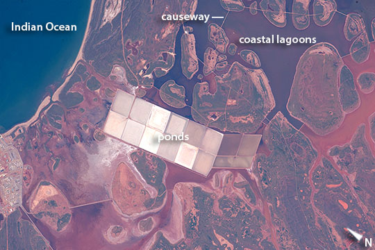 |
| Salt Ponds, coastal flats, Western Australia Coastlines are usually the best indicators for astronauts in telling them quickly which part of the world they are looking at from the windows of the International Space Station. Here coastal lagoons with numerous rounded islands are typical of the Indian Ocean coastline of Western Australia. These shapes contrast with the angular, white ponds of the salt extraction industry. Muddy red-brown inland water (image right and lower left) from recent rains is prevented by low causeways from mixing with darker (clearer) water nearer the coast. This coast of Australia is noted for its tropical climate and remoteness. It once had a pearling industry, and has experienced more direct hits by cyclones than any other place on this long stretch of Western Australia's coastline. The repeated hits almost resulted in the decision to permanently evacuate the small town of Onslow (just outside the image). The Monte Bello islands offshore (outside the image to the north) are guarded as defunct sites of atomic bomb tests. |
| Images: | All Available Images Low-Resolution 102k |
|
| Mission: | ISS044 |
|
| Roll - Frame: | E - 868 |
|
| Geographical Name: | AUSTRALIA-WA |
|
| Features: | SALT PONDS, LAGOON, ISLANDS |
|
| Center Lat x Lon: | 21.7S x 115.1E |
|
| Film Exposure: | N=Normal exposure, U=Under exposed, O=Over exposed, F=out of Focus |
|
| Percentage of Cloud Cover-CLDP: | 10 |
|
| Camera:: | N6 |
|
| Camera Tilt: | 16 | LO=Low Oblique, HO=High Oblique, NV=Near Vertical |
| Camera Focal Length: | 1150 |
|
| Nadir to Photo Center Direction: | NW | The direction from the nadir to the center point, N=North, S=South, E=East, W=West |
| Stereo?: | Y=Yes there is an adjacent picture of the same area, N=No there isn't |
|
| Orbit Number: | |
|
| Date: | 20150611 | YYYYMMDD |
| Time: | 051935 | GMT HHMMSS |
| Nadir Lat: | 22.2S |
Latitude of suborbital point of spacecraft |
| Nadir Lon: | 116.0E |
Longitude of suborbital point of spacecraft |
| Sun Azimuth: | 340 | Clockwise angle in degrees from north to the sun measured at the nadir point |
| Space Craft Altitude: | 218 | nautical miles |
| Sun Elevation: | 42 | Angle in degrees between the horizon and the sun, measured at the nadir point |
| Land Views: | COAST |
|
| Water Views: | OCEAN |
|
| Atmosphere Views: | |
|
| Man Made Views: | |
|
| City Views: | |
|
Photo is not associated with any sequences | ||
| NASA Home Page |
JSC Home Page |
JSC Digital Image Collection |
Earth Science & Remote Sensing |
|
This service is provided by the International Space Station program and the JSC Earth Science & Remote Sensing Unit, ARES Division, Exploration Integration Science Directorate.

|