Geographic Region: BRAZIL
Feature: CENTERPIVOT IRRIGATION CIRCLES, FARMHOUSE
|
Geographic Region: BRAZIL Feature: CENTERPIVOT IRRIGATION CIRCLES, FARMHOUSE |
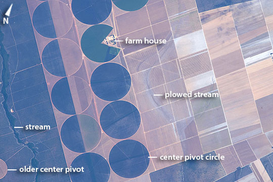 |
| New center pivot systems, Bahia State, Brazil Astronauts aboard the International Space Station would have seen a different human pattern in this part of Bahia State in central Brazil in 2013 where imagery shows only one center-pivot irrigation circle (image extreme lower left). This detailed astronaut image--the circles are 2 km in diameter--shows a raft of new circles tightly packed on top of the original rectangular farm grid. Like a Pac-Man one circle appears to be swallowing up a farm house (image upper left). The ragged lines of a forested stream a (far left) contrast with the sweeping, ghostly shapes of ploughed stream beds appear image center. As Brazil's economy rapidly expands, center-pivot irrigation technology is being introduced to counter the effects of irregular rains and drought in Bahia's drier interior. Agribusiness crops grown in this part of the state are soy beans, corn, cotton and sisal. The nearby town of Magalhaes has experienced the fastest growth in all of Brazil - its population more than doubled between 2004 and 2007. |
| Images: | All Available Images Low-Resolution 80k |
|
| Mission: | ISS044 |
|
| Roll - Frame: | E - 22556 |
|
| Geographical Name: | BRAZIL |
|
| Features: | CENTERPIVOT IRRIGATION CIRCLES, FARMHOUSE |
|
| Center Lat x Lon: | 11.7S x 45.7W |
|
| Film Exposure: | N=Normal exposure, U=Under exposed, O=Over exposed, F=out of Focus |
|
| Percentage of Cloud Cover-CLDP: | 0 |
|
| Camera:: | N6 |
|
| Camera Tilt: | 24 | LO=Low Oblique, HO=High Oblique, NV=Near Vertical |
| Camera Focal Length: | 1150 |
|
| Nadir to Photo Center Direction: | NW | The direction from the nadir to the center point, N=North, S=South, E=East, W=West |
| Stereo?: | Y=Yes there is an adjacent picture of the same area, N=No there isn't |
|
| Orbit Number: | |
|
| Date: | 20150726 | YYYYMMDD |
| Time: | 115444 | GMT HHMMSS |
| Nadir Lat: | 12.8S |
Latitude of suborbital point of spacecraft |
| Nadir Lon: | 44.5W |
Longitude of suborbital point of spacecraft |
| Sun Azimuth: | 56 | Clockwise angle in degrees from north to the sun measured at the nadir point |
| Space Craft Altitude: | 218 | nautical miles |
| Sun Elevation: | 33 | Angle in degrees between the horizon and the sun, measured at the nadir point |
| Land Views: | |
|
| Water Views: | |
|
| Atmosphere Views: | |
|
| Man Made Views: | PIVOT IRRIGATION |
|
| City Views: | |
|
Photo is not associated with any sequences | ||
| NASA Home Page |
JSC Home Page |
JSC Digital Image Collection |
Earth Science & Remote Sensing |
|
This service is provided by the International Space Station program and the JSC Earth Science & Remote Sensing Unit, ARES Division, Exploration Integration Science Directorate.

|