 Photo #: ISS043-E-175007 Date: May 2015
Geographic Region: RUSSIAN FEDERATION
Feature: KLIUCHEVSKOI VOL., KAMCHATKA PEN., SNOW

 Photo #: ISS043-E-175007 Date: May 2015 Photo #: ISS043-E-175007 Date: May 2015Geographic Region: RUSSIAN FEDERATION Feature: KLIUCHEVSKOI VOL., KAMCHATKA PEN., SNOW |
 |
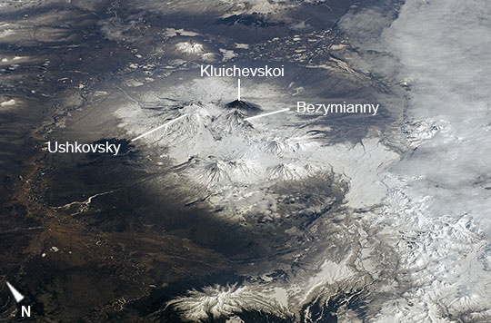
| Activity at Kliuchevskoi Volcano, Kamchatka Peninsula, Russia This image, taken by astronauts on board the International Space Station, highlights one of the most active volcanic regions on Earth - the Kamchatka Peninsula in far eastern Russia. The three largest volcanoes visible at image center include Kliuchevskoi, Bezymianny, and Ushkovsky. Kliuchevskoi is the most active volcano with geologic, historical, and observational data indicating no major periods of quiescence since the volcano formed approximately 6000 years ago. A thin ash and steam plume is visible extending to the east-southeast from the summit of Kliuchevskoi, typical of activity reported at the volcano from 2-5 May 2015 when the image was taken. The flanks of the volcano are also covered with dark ash deposits, in contrast to the snow-covered flanks of both Bezymianny and Ushkovsky. The Kamchatka Peninsula boasts one of the highest concentrations of volcanic geologic features on Earth, including over 300 identified volcanoes (29 considered active), hot springs, and geysers. In addition, abundant volcanic rock exposures and volcanogenic sediments attest to the highly active tectonic setting of the peninsula, a result of subduction of the Pacific oceanic plate beneath the overriding Eurasia continental plate. In addition to the high geological interest of the region, the peninsula's abundant wildlife and distinctive coastal and inland geography led to designation of the UNESCO Volcanoes of Kamchatka World Heritage Site in 1996 (extended in 2001). |
| Images: | All Available Images Low-Resolution 90k |
|
| Mission: | ISS043 |
|
| Roll - Frame: | E - 175007 |
|
| Geographical Name: | RUSSIAN FEDERATION |
|
| Features: | KLIUCHEVSKOI VOL., KAMCHATKA PEN., SNOW |
|
| Center Lat x Lon: | 55.7N x 160.8E |
|
| Film Exposure: | N=Normal exposure, U=Under exposed, O=Over exposed, F=out of Focus |
|
| Percentage of Cloud Cover-CLDP: | 10 |
|
| Camera:: | N6 |
|
| Camera Tilt: | HO | LO=Low Oblique, HO=High Oblique, NV=Near Vertical |
| Camera Focal Length: | 210 |
|
| Nadir to Photo Center Direction: | NE | The direction from the nadir to the center point, N=North, S=South, E=East, W=West |
| Stereo?: | Y=Yes there is an adjacent picture of the same area, N=No there isn't |
|
| Orbit Number: | |
|
| Date: | 20150504 | YYYYMMDD |
| Time: | 232709 | GMT HHMMSS |
| Nadir Lat: | 50.1N |
Latitude of suborbital point of spacecraft |
| Nadir Lon: | 155.5E |
Longitude of suborbital point of spacecraft |
| Sun Azimuth: | 131 | Clockwise angle in degrees from north to the sun measured at the nadir point |
| Space Craft Altitude: | 213 | nautical miles |
| Sun Elevation: | 48 | Angle in degrees between the horizon and the sun, measured at the nadir point |
| Land Views: | PENINSULA, VOLCANO |
|
| Water Views: | |
|
| Atmosphere Views: | PLUME |
|
| Man Made Views: | |
|
| City Views: | |
|
Photo is not associated with any sequences | ||
| NASA Home Page |
JSC Home Page |
JSC Digital Image Collection |
Earth Science & Remote Sensing |
|
|