
Geographic Region: USA-TENNESSEE
Feature: MEMPHIS, MISSISSIPPI R., AGR.
|
Geographic Region: USA-TENNESSEE Feature: MEMPHIS, MISSISSIPPI R., AGR. |
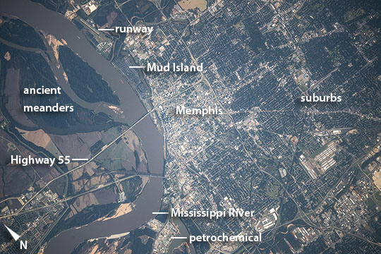 |
| Memphis, Tennessee Astronauts aboard the International Space Station took this detailed image of the city known as Bluff City because of its location on high bluffs well above flood levels of the Mississippi River. The city center appears as a light gray tone facing a broad bend of the brown Mississippi River. Surrounding suburbs are green and distinctly darker. Cutting the grid of the city street pattern are major roads that radiate from the city center. The runway of a local airport appears top left next to the river. Memphis lies where Tennessee adjoins Arkansas and Mississippi, and the population of greater Memphis (1.34 million) sprawls into these neighboring states, well beyond the area shown in this image. The city is a major regional transportation hub, with barge traffic on the river (barges can be seen in this image opposite Mud Island) and several Interstate highways passing through it. Bridges for two interstates cross the river, and their shadows even appear in this detailed view (for scale, the Interstate 55 bridge is 0.7 miles long). The low country opposite the city center is dominated by agricultural fields and the broad sweep of ancient meanders of the Mississippi River. Little Rock, Arkansas is a city on the opposite side of the Mississippi valley with a similar location on bluffs overlooking meander scars of the Arkansas River, a major tributary of the Mississippi River. |
| Images: | All Available Images Low-Resolution 125k |
|
| Mission: | ISS041 |
|
| Roll - Frame: | E - 105523 |
|
| Geographical Name: | USA-TENNESSEE |
|
| Features: | MEMPHIS, MISSISSIPPI R., AGR. |
|
| Center Lat x Lon: | 35.1N x 90W |
|
| Film Exposure: | N=Normal exposure, U=Under exposed, O=Over exposed, F=out of Focus |
|
| Percentage of Cloud Cover-CLDP: | 10 |
|
| Camera:: | N6 |
|
| Camera Tilt: | 45 | LO=Low Oblique, HO=High Oblique, NV=Near Vertical |
| Camera Focal Length: | 800 |
|
| Nadir to Photo Center Direction: | SW | The direction from the nadir to the center point, N=North, S=South, E=East, W=West |
| Stereo?: | Y=Yes there is an adjacent picture of the same area, N=No there isn't |
|
| Orbit Number: | |
|
| Date: | 20141030 | YYYYMMDD |
| Time: | 152924 | GMT HHMMSS |
| Nadir Lat: | 37.0N |
Latitude of suborbital point of spacecraft |
| Nadir Lon: | 86.8W |
Longitude of suborbital point of spacecraft |
| Sun Azimuth: | 145 | Clockwise angle in degrees from north to the sun measured at the nadir point |
| Space Craft Altitude: | 220 | nautical miles |
| Sun Elevation: | 32 | Angle in degrees between the horizon and the sun, measured at the nadir point |
| Land Views: | VALLEY |
|
| Water Views: | RIVER |
|
| Atmosphere Views: | |
|
| Man Made Views: | AIRPORT, BRIDGE |
|
| City Views: | MEMPHIS |
|
Photo is not associated with any sequences | ||
| NASA Home Page |
JSC Home Page |
JSC Digital Image Collection |
Earth Science & Remote Sensing |
|
This service is provided by the International Space Station program and the JSC Earth Science & Remote Sensing Unit, ARES Division, Exploration Integration Science Directorate.

|