Geographic Region: RUSSIAN FEDERATION
Feature: L. BAIKAL, ICE, SMOKE
|
Geographic Region: RUSSIAN FEDERATION Feature: L. BAIKAL, ICE, SMOKE |
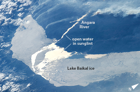 |
| Lake Baikal ice melts, Russia In this late afternoon shot, the crew aboard the International Space Station looked back toward the setting sun and captured the hook-shaped southern half of Lake Baikal in eastern Russia. Most of the lake is covered with dull gray ice. The brightest point in the center of the image is the reflection of the sun's rays off a small zone of open water where the ice has begun to melt. Broken ice masses appear adjacent to the sunglint point. The sun's rays are also reflected off the water surface of the straight Angara River, the main outlet of the lake. Lake Baikal is 636 km long (395 mi). It is the deepest lake in the world and holds the largest amount of fresh water. Individual smoke plumes arc away from the north shore (image top left). Large smoke palls from wildfires appear image upper right. |
| Images: | All Available Images Low-Resolution 230k |
|
| Mission: | ISS039 |
|
| Roll - Frame: | E - 14821 |
|
| Geographical Name: | RUSSIAN FEDERATION |
|
| Features: | L. BAIKAL, ICE, SMOKE |
|
| Center Lat x Lon: | 51.9N x 105.3E |
|
| Film Exposure: | N=Normal exposure, U=Under exposed, O=Over exposed, F=out of Focus |
|
| Percentage of Cloud Cover-CLDP: | 25 |
|
| Camera:: | N5 |
|
| Camera Tilt: | HO | LO=Low Oblique, HO=High Oblique, NV=Near Vertical |
| Camera Focal Length: | 145 |
|
| Nadir to Photo Center Direction: | W | The direction from the nadir to the center point, N=North, S=South, E=East, W=West |
| Stereo?: | Y=Yes there is an adjacent picture of the same area, N=No there isn't |
|
| Orbit Number: | |
|
| Date: | 20140422 | YYYYMMDD |
| Time: | 095538 | GMT HHMMSS |
| Nadir Lat: | 51.4N |
Latitude of suborbital point of spacecraft |
| Nadir Lon: | 115.9E |
Longitude of suborbital point of spacecraft |
| Sun Azimuth: | 274 | Clockwise angle in degrees from north to the sun measured at the nadir point |
| Space Craft Altitude: | 222 | nautical miles |
| Sun Elevation: | 13 | Angle in degrees between the horizon and the sun, measured at the nadir point |
| Land Views: | |
|
| Water Views: | ICE, LAKE, RIVER, SUNGLINT |
|
| Atmosphere Views: | SMOKE |
|
| Man Made Views: | |
|
| City Views: | |
|
Photo is not associated with any sequences | ||
| NASA Home Page |
JSC Home Page |
JSC Digital Image Collection |
Earth Science & Remote Sensing |
|
This service is provided by the International Space Station program and the JSC Earth Science & Remote Sensing Unit, ARES Division, Exploration Integration Science Directorate.

|