 Photo #: ISS038-E-16335 Date: Dec. 2013
Geographic Region: UNITED ARAB EMIRATES
Feature: ABU DHABI, DUBAI AT NIGHT

 Photo #: ISS038-E-16335 Date: Dec. 2013 Photo #: ISS038-E-16335 Date: Dec. 2013Geographic Region: UNITED ARAB EMIRATES Feature: ABU DHABI, DUBAI AT NIGHT |
 |
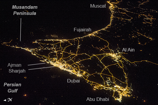
| United Arab Emirates, Persian Gulf, At Night Geographers like night images of cities because you see immediately so much about the human landscape--things that are difficult or impossible to see in day images. You see where the cities are located and their shape; the brightest light clusters frequently indicate the city centers. In large field of view images, such as this astronaut photograph of the United Arab Emirates (UAE) from the International Space Station (ISS), you can also see cities' position relative to one another and their relative size. Here the largest cluster of lights is the conurbation ("joined cities") of Dubai-Sharjah-Ajman (population 3.25 million), with its smaller neighbor Dubai (population 2.1 million). These cities front onto the Persian Gulf (also known as the Arabian Gulf) where the city lights are cut off abruptly at the coastline. The bright city centers are located at the coast showing that sea trade is important (and has been important) in the growth of these cities. Smaller cities are Al Ain (population 518,000), the fourth largest city in the UAE, and Fujairah (population 152,000). Major highways join the cities in a brightly lit network, and a faint peppering of lights offshore shows the relatively young oil and gas platforms on either side of the Musandam Peninsula (image left). Despite being taken at night, the spike of the Musandam Peninsula is easy to imagine at the south end of the Persian Gulf. The biggest cities in the UAE are Abu Dhabi and Dubai. Muscat, the capital city of the neighboring country of Oman, appears image top center. By contrast, the almost unpopulated Musandam Peninsula shows very few lights. |
| Images: | All Available Images Low-Resolution 251k |
|
| Mission: | ISS038 |
|
| Roll - Frame: | E - 16335 |
|
| Geographical Name: | UNITED ARAB EMIRATES |
|
| Features: | ABU DHABI, DUBAI AT NIGHT |
|
| Center Lat x Lon: | 24.7N x 55.8E |
|
| Film Exposure: | N=Normal exposure, U=Under exposed, O=Over exposed, F=out of Focus |
|
| Percentage of Cloud Cover-CLDP: | 10 |
|
| Camera:: | N5 |
|
| Camera Tilt: | 54 | LO=Low Oblique, HO=High Oblique, NV=Near Vertical |
| Camera Focal Length: | 85 |
|
| Nadir to Photo Center Direction: | E | The direction from the nadir to the center point, N=North, S=South, E=East, W=West |
| Stereo?: | Y=Yes there is an adjacent picture of the same area, N=No there isn't |
|
| Orbit Number: | |
|
| Date: | 20131211 | YYYYMMDD |
| Time: | 221645 | GMT HHMMSS |
| Nadir Lat: | 25.4N |
Latitude of suborbital point of spacecraft |
| Nadir Lon: | 50.7E |
Longitude of suborbital point of spacecraft |
| Sun Azimuth: | 90 | Clockwise angle in degrees from north to the sun measured at the nadir point |
| Space Craft Altitude: | 221 | nautical miles |
| Sun Elevation: | -66 | Angle in degrees between the horizon and the sun, measured at the nadir point |
| Land Views: | PENINSULA |
|
| Water Views: | GULF |
|
| Atmosphere Views: | |
|
| Man Made Views: | |
|
| City Views: | ABU DHABI, DUBAI, MUSCAT |
|
Photo is not associated with any sequences | ||
| NASA Home Page |
JSC Home Page |
JSC Digital Image Collection |
Earth Science & Remote Sensing |
|
|