Geographic Region: UZBEKISTAN
Feature: SAMARKAND, ZERVASHAN R., JOMBOY
|
Geographic Region: UZBEKISTAN Feature: SAMARKAND, ZERVASHAN R., JOMBOY |
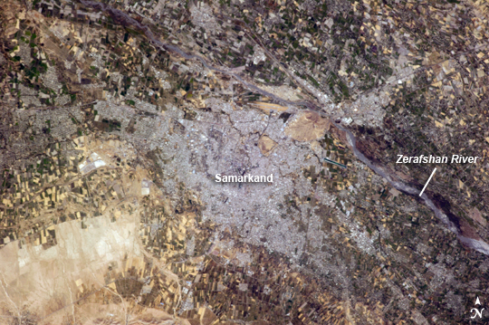 |
| Samarkand, Uzbekistan The historical Silk Road - or as some scholars prefer, Silk Routes (as there were several "roads") - provided trade routes between Asia and Europe from 206 BC; parts of the Silk Road are still used for transport of goods today. The city of Samarkand, featured in this astronaut photograph from the International Space Station, is one of the oldest and historically most important cities along the Road, occupying a central position between China and the Western nations of Europe. The city is thought to have been founded around 700 BC. In addition to its continual role as a trade center, many events have occurred in the city's long history, including conquering by Alexander the Great(329 BC) and Genghis Khan (1220); becoming the capital city of the empire of Tamerlane, or Timur (1370); the capital city of the Uzbek Soviet Socialist Republic from 1925-1930; and being added to the UNESCO World Heritage List in 2001. Today, Samarkand is the second largest city in the Republic of Uzbekistan (formed in 1991). The urban area (image center) is located within a large oasis situated in the Zerafshan River Valley of southeastern Uzbekistan. Historical accounts of Samarkand describe it as a "paradise", and this favorable climate today still supports extensive agriculture; field are particularly evident to the southwest of the city (green - active; tan - fallow at image lower left). In keeping with its status as a World Heritage site, the city attracts many international visitors due to its preservation of historical and cultural monuments. As the capital of the Samarkand Province, it also serves as the regional government administrative center. |
| Images: | All Available Images Low-Resolution 323k |
|
| Mission: | ISS037 |
|
| Roll - Frame: | E - 719 |
|
| Geographical Name: | UZBEKISTAN |
|
| Features: | SAMARKAND, ZERVASHAN R., JOMBOY |
|
| Center Lat x Lon: | 39.6N x 66.9E |
|
| Film Exposure: | N=Normal exposure, U=Under exposed, O=Over exposed, F=out of Focus |
|
| Percentage of Cloud Cover-CLDP: | 10 |
|
| Camera:: | N5 |
|
| Camera Tilt: | 15 | LO=Low Oblique, HO=High Oblique, NV=Near Vertical |
| Camera Focal Length: | 400 |
|
| Nadir to Photo Center Direction: | N | The direction from the nadir to the center point, N=North, S=South, E=East, W=West |
| Stereo?: | Y=Yes there is an adjacent picture of the same area, N=No there isn't |
|
| Orbit Number: | |
|
| Date: | 20130913 | YYYYMMDD |
| Time: | 073304 | GMT HHMMSS |
| Nadir Lat: | 38.6N |
Latitude of suborbital point of spacecraft |
| Nadir Lon: | 67.0E |
Longitude of suborbital point of spacecraft |
| Sun Azimuth: | 182 | Clockwise angle in degrees from north to the sun measured at the nadir point |
| Space Craft Altitude: | 221 | nautical miles |
| Sun Elevation: | 55 | Angle in degrees between the horizon and the sun, measured at the nadir point |
| Land Views: | VALLEY |
|
| Water Views: | RIVER |
|
| Atmosphere Views: | |
|
| Man Made Views: | AGRICULTURE, URBAN AREA |
|
| City Views: | |
|
Photo is not associated with any sequences | ||
| NASA Home Page |
JSC Home Page |
JSC Digital Image Collection |
Earth Science & Remote Sensing |
|
This service is provided by the International Space Station program and the JSC Earth Science & Remote Sensing Unit, ARES Division, Exploration Integration Science Directorate.

|