 Photo #: ISS036-E-25802 Date: Jul. 2013
Geographic Region: SAUDI ARABIA
Feature: JEDDAH AT NIGHT,MECCA AT NIGHT,ABHA AT NIGHT,KHAMIS MUSHAIT AT NIGHT

 Photo #: ISS036-E-25802 Date: Jul. 2013 Photo #: ISS036-E-25802 Date: Jul. 2013Geographic Region: SAUDI ARABIA Feature: JEDDAH AT NIGHT,MECCA AT NIGHT,ABHA AT NIGHT,KHAMIS MUSHAIT AT NIGHT |
 |
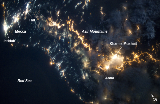
| Southwestern Saudi Arabia at Night This striking image of the southwestern Saudi Arabia coastline was taken by astronauts on board the International Space Station. In addition to city lights, patchy cloud cover partially obscures and blurs city lights, especially in the vicinity of Khamis Mushait and Abha. While much of the country is lightly populated desert - and relatively dark at night due to lack of city and roadway lights - the southwestern coastal region has more moderate climate and several large cities. Three brightly lit urban centers are visible at image top left; Jeddah, Mecca, and Taif. Jeddah is the gateway city for Islamic pilgrims going to nearby Mecca (a religious journey known as the hajj). Taif to the east is located on the slopes of the Sarawat Mountains, and provides a summer retreat for the Saudi government from the desert heat of the capital city of Riyadh. Bright yellow-orange lighting marks highways that parallel the trend of the Asir Mountains at image center, connecting Mecca to the resort cities of Al Bahah and Abha (image lower right). Smaller roadways, lit with blue lights, extend to the west to small cities along the Red Sea coastline. The bright yellow-orange glow of the city of Abha is matched by that of the city of Khamis Mushait (or Khamis Mushayt) to the northeast. The brightly lit ribbon of highway continues onward towards other large cities to the south (Jazan, not shown) and southeast (Najran, not shown). |
| Images: | All Available Images Low-Resolution 199k |
|
| Mission: | ISS036 |
|
| Roll - Frame: | E - 25802 |
|
| Geographical Name: | SAUDI ARABIA |
|
| Features: | JEDDAH AT NIGHT,MECCA AT NIGHT,ABHA AT NIGHT,KHAMIS MUSHAIT AT NIGHT |
|
| Center Lat x Lon: | 19.0N x 42.5E |
|
| Film Exposure: | N=Normal exposure, U=Under exposed, O=Over exposed, F=out of Focus |
|
| Percentage of Cloud Cover-CLDP: | 25 |
|
| Camera:: | N5 |
|
| Camera Tilt: | 42 | LO=Low Oblique, HO=High Oblique, NV=Near Vertical |
| Camera Focal Length: | 50 |
|
| Nadir to Photo Center Direction: | NW | The direction from the nadir to the center point, N=North, S=South, E=East, W=West |
| Stereo?: | Y=Yes there is an adjacent picture of the same area, N=No there isn't |
|
| Orbit Number: | |
|
| Date: | 20130726 | YYYYMMDD |
| Time: | 194353 | GMT HHMMSS |
| Nadir Lat: | 16.9N |
Latitude of suborbital point of spacecraft |
| Nadir Lon: | 45.1E |
Longitude of suborbital point of spacecraft |
| Sun Azimuth: | 330 | Clockwise angle in degrees from north to the sun measured at the nadir point |
| Space Craft Altitude: | 225 | nautical miles |
| Sun Elevation: | -49 | Angle in degrees between the horizon and the sun, measured at the nadir point |
| Land Views: | |
|
| Water Views: | |
|
| Atmosphere Views: | |
|
| Man Made Views: | HIGHWAY |
|
| City Views: | MECCA |
|
Photo is not associated with any sequences | ||
| NASA Home Page |
JSC Home Page |
JSC Digital Image Collection |
Earth Science & Remote Sensing |
|
|