
Geographic Region: USA-ARIZONA
Feature: PHOENIX AT NIGHT,GLENDALE AT NIGHT,PEORIA AT NIGHT,SALT RIVER VALLEY
|
Geographic Region: USA-ARIZONA Feature: PHOENIX AT NIGHT,GLENDALE AT NIGHT,PEORIA AT NIGHT,SALT RIVER VALLEY |
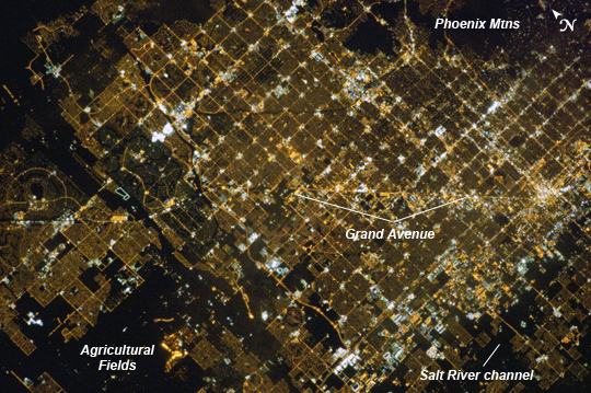 |
| Phoenix, AZ Metropolitan Area at Night Like many large urban areas of the central and western United States, the Phoenix, AZ metropolitan area is laid out along a regular grid of city blocks and streets. While visible during the day this grid is most evident at night, when the pattern of street lighting is clearly visible from above - in the case of this astronaut photograph, from the low Earth orbit vantage point of the International Space Station. The urban grid form encourages growth of a city outwards along its borders, by providing optimal access to new real estate. Fueled by the adoption of widespread personal automobile use during the 20th century, the Phoenix metropolitan area today includes 25 other municipalities (many of them largely suburban and residential in character) linked by a network of surface streets and freeways. This astronaut photograph includes parts of several cities in the metro area including Phoenix (image right), Glendale (image center), and Peoria (image left). While the major street grid is oriented north-south, the northwest-southeast oriented Grand Avenue cuts across it at image center. Grand Avenue is a major transportation corridor through the western metropolitan area; the lighting patterns of large industrial and commercial properties are visible along its length. Other brightly lit properties include large shopping centers, strip centers, and gas stations which tend to be located at the intersections of north-south and east-west trending streets. While much of the land area highlighted in this image is urbanized, there are several noticeably dark areas. The Phoenix Mountains at image upper right are largely public park and recreational land. To the west (image lower left), agricultural fields provide a sharp contrast to the lit streets of neighboring residential developments. The Salt River channel appears as a dark ribbon within the urban grid at image lower right. |
| Images: | All Available Images Low-Resolution 353k |
|
| Mission: | ISS035 |
|
| Roll - Frame: | E - 5438 |
|
| Geographical Name: | USA-ARIZONA |
|
| Features: | PHOENIX AT NIGHT,GLENDALE AT NIGHT,PEORIA AT NIGHT,SALT RIVER VALLEY |
|
| Center Lat x Lon: | 33.5N x 112.2W |
|
| Film Exposure: | N=Normal exposure, U=Under exposed, O=Over exposed, F=out of Focus |
|
| Percentage of Cloud Cover-CLDP: | 10 |
|
| Camera:: | N5 |
|
| Camera Tilt: | 14 | LO=Low Oblique, HO=High Oblique, NV=Near Vertical |
| Camera Focal Length: | 400 |
|
| Nadir to Photo Center Direction: | SE | The direction from the nadir to the center point, N=North, S=South, E=East, W=West |
| Stereo?: | Y=Yes there is an adjacent picture of the same area, N=No there isn't |
|
| Orbit Number: | |
|
| Date: | 20130316 | YYYYMMDD |
| Time: | 115650 | GMT HHMMSS |
| Nadir Lat: | 34.0N |
Latitude of suborbital point of spacecraft |
| Nadir Lon: | 112.9W |
Longitude of suborbital point of spacecraft |
| Sun Azimuth: | 76 | Clockwise angle in degrees from north to the sun measured at the nadir point |
| Space Craft Altitude: | 214 | nautical miles |
| Sun Elevation: | -22 | Angle in degrees between the horizon and the sun, measured at the nadir point |
| Land Views: | |
|
| Water Views: | CHANNEL, RIVER |
|
| Atmosphere Views: | |
|
| Man Made Views: | |
|
| City Views: | PEORIA, PHOENIX |
|
Photo is not associated with any sequences | ||
| NASA Home Page |
JSC Home Page |
JSC Digital Image Collection |
Earth Science & Remote Sensing |
|
This service is provided by the International Space Station program and the JSC Earth Science & Remote Sensing Unit, ARES Division, Exploration Integration Science Directorate.

|