Geographic Region: BELGIUM
Feature: ESA NIGHTPOD - LIEGE-AACHEN-VERNIERS AREA AT NIGHT
|
Geographic Region: BELGIUM Feature: ESA NIGHTPOD - LIEGE-AACHEN-VERNIERS AREA AT NIGHT |
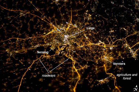 |
| Liege, Belgium at Night Note: This caption refers to the image versions labeled "NASA's Earth Observatory web site". To paraphrase the old expression, "all roads lead to Liege" - or at least one could get that impression from this night time astronaut photograph taken from the International Space Station (ISS). The brightly lit core of the Liege urban area appears to lie at the center of a network of roadways--traceable by continuous orange lighting--extending outwards into the rural, and relatively dark, Belgium countryside. For a sense of scale the distance from image left to image right is approximately 70 kilometers. The region at image lower right to the southeast of Verviers includes agricultural fields and forest; hence it appears almost uniformly dark at night. The image was taken using the European Space Agency's Nodding mechanism, also known as the NightPod. NightPod is an electro-mechanical mount system designed to compensate digital cameras for the motion of the ISS relative to the Earth. The primary mission goal was to take high-resolution, long exposure digital imagery of the Earth from the ISS Cupola, particularly cities at night. While the official NightPod mission has been completed, the mechanism remains on board for astronauts to use. Liege is the third most populous metropolitan region in Belgium (after Brussels and Antwerp); it includes 52 municipalities, including the nearby city of Seraing. It is also an important economic center for the country, including a diverse array of industries including (among others) mechanical, information and biotechnology, beer and chocolate, light armaments, and steel-making. The metropolitan area also boasts a wide array of cultural, historical, and artistic attractions making it a popular destination among the neighboring countries of France, Germany, and the Netherlands. |
| Images: | All Available Images Low-Resolution 285k |
|
| Mission: | ISS034 |
|
| Roll - Frame: | E - 5935 |
|
| Geographical Name: | BELGIUM |
|
| Features: | ESA NIGHTPOD - LIEGE-AACHEN-VERNIERS AREA AT NIGHT |
|
| Center Lat x Lon: | 50.6N x 5.8E |
|
| Film Exposure: | N=Normal exposure, U=Under exposed, O=Over exposed, F=out of Focus |
|
| Percentage of Cloud Cover-CLDP: | 0 |
|
| Camera:: | N5 |
|
| Camera Tilt: | 39 | LO=Low Oblique, HO=High Oblique, NV=Near Vertical |
| Camera Focal Length: | 180 |
|
| Nadir to Photo Center Direction: | W | The direction from the nadir to the center point, N=North, S=South, E=East, W=West |
| Stereo?: | Y=Yes there is an adjacent picture of the same area, N=No there isn't |
|
| Orbit Number: | |
|
| Date: | 20121208 | YYYYMMDD |
| Time: | 213911 | GMT HHMMSS |
| Nadir Lat: | 51.2N |
Latitude of suborbital point of spacecraft |
| Nadir Lon: | 8.6E |
Longitude of suborbital point of spacecraft |
| Sun Azimuth: | 317 | Clockwise angle in degrees from north to the sun measured at the nadir point |
| Space Craft Altitude: | 215 | nautical miles |
| Sun Elevation: | -56 | Angle in degrees between the horizon and the sun, measured at the nadir point |
| Land Views: | |
|
| Water Views: | |
|
| Atmosphere Views: | |
|
| Man Made Views: | URBAN AREA |
|
| City Views: | |
|
Photo is not associated with any sequences | ||
| NASA Home Page |
JSC Home Page |
JSC Digital Image Collection |
Earth Science & Remote Sensing |
|
This service is provided by the International Space Station program and the JSC Earth Science & Remote Sensing Unit, ARES Division, Exploration Integration Science Directorate.

|