Geographic Region: WAKE ISLAND
Feature: WAKE I., REEFS, AIRPORT, PACIFIC O.
|
Geographic Region: WAKE ISLAND Feature: WAKE I., REEFS, AIRPORT, PACIFIC O. |
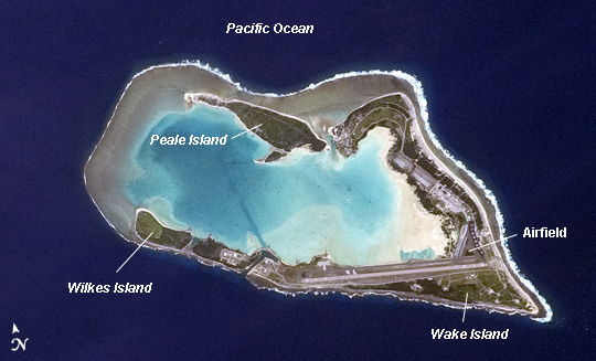 |
| Wake Island, Pacific Ocean Note: This caption refers to the image versions labeled "NASA's Earth Observatory web site". The atoll of Wake Island is located in the central Pacific Ocean approximately 4000 kilometers to the west-southwest of Hawaii and 2400 kilometers to the northwest of Guam. In addition to Wake Island, the atoll includes the smaller Peale and Wilkes Island for a total land surface area of 6.5 square kilometers. Like many atolls in the Pacific, the islands and associated reefs formed around a submerged volcano. The lagoon (image center) in the center of the islands--characterized by shallow, light blue water in contrast to the surrounding darker, deeper Pacific Ocean waters--marks the approximate location of the summit crater of the volcano. Wake Island was annexed by the United States of America (USA) in 1899, and it became an important military and commercial airfield by 1935. Following the bombing of Pearl Harbor and the mutual declaration of war between the USA and the Empire of Japan in 1941, the atoll was occupied by Japanese forces until the end of the war in the Pacific (1945). Today, the civil administration of the atoll is the responsibility of the US Department of the Interior, while the US Air Force and US Army maintain military facilities and operations (including an airfield and large ship anchorages). With the exception of direct support to missions--and potentially, emergency airplane landings--there are no commercial or civilian flights to Wake Island. During 2006, Wake Island was in the path of Super Typhoon Ioke. Given the danger, the entire civilian and military population of the atoll was evacuated. While some damage to buildings and facilities occurred as a result of the storm, a US Air Force repair team subsequently restored full capabilities for strategic use of the atoll. |
| Images: | All Available Images Low-Resolution 193k |
|
| Mission: | ISS033 |
|
| Roll - Frame: | E - 7873 |
|
| Geographical Name: | WAKE ISLAND |
|
| Features: | WAKE I., REEFS, AIRPORT, PACIFIC O. |
|
| Center Lat x Lon: | 19.3N x 166.6E |
|
| Film Exposure: | N=Normal exposure, U=Under exposed, O=Over exposed, F=out of Focus |
|
| Percentage of Cloud Cover-CLDP: | 10 |
|
| Camera:: | N5 |
|
| Camera Tilt: | 18 | LO=Low Oblique, HO=High Oblique, NV=Near Vertical |
| Camera Focal Length: | 400 |
|
| Nadir to Photo Center Direction: | SW | The direction from the nadir to the center point, N=North, S=South, E=East, W=West |
| Stereo?: | Y=Yes there is an adjacent picture of the same area, N=No there isn't |
|
| Orbit Number: | |
|
| Date: | 20120927 | YYYYMMDD |
| Time: | 211904 | GMT HHMMSS |
| Nadir Lat: | 19.9N |
Latitude of suborbital point of spacecraft |
| Nadir Lon: | 167.6E |
Longitude of suborbital point of spacecraft |
| Sun Azimuth: | 108 | Clockwise angle in degrees from north to the sun measured at the nadir point |
| Space Craft Altitude: | 219 | nautical miles |
| Sun Elevation: | 36 | Angle in degrees between the horizon and the sun, measured at the nadir point |
| Land Views: | ATOLL, ISLAND |
|
| Water Views: | LAGOON, OCEAN |
|
| Atmosphere Views: | |
|
| Man Made Views: | HARBOR |
|
| City Views: | |
|
Photo is not associated with any sequences | ||
| NASA Home Page |
JSC Home Page |
JSC Digital Image Collection |
Earth Science & Remote Sensing |
|
This service is provided by the International Space Station program and the JSC Earth Science & Remote Sensing Unit, ARES Division, Exploration Integration Science Directorate.

|