Geographic Region: ARGENTINA
Feature: PAYUN MATRU VOLCANO,LAVA FLOWS,SANTA MARIA VOLCANO
|
Geographic Region: ARGENTINA Feature: PAYUN MATRU VOLCANO,LAVA FLOWS,SANTA MARIA VOLCANO |
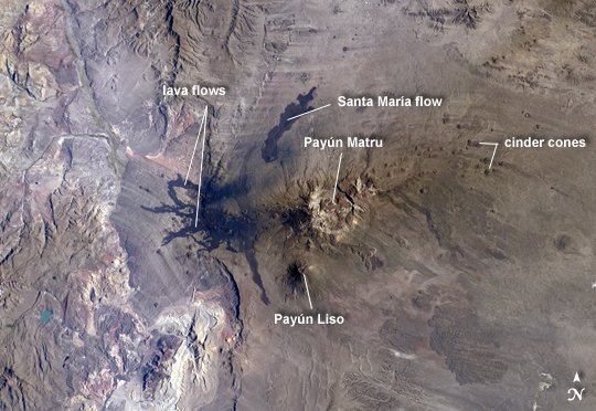 |
| Note: This caption refers to the image versions labeled "NASA's Earth Observatory web site". The Payun Matru (3680 m asl) and Payun Liso (3715 meters asl) stratovolcanoes are the highest points of the Payun Matru Volcanic Field located in west-central Argentina, approximately 140 kilometers to the east of the Andes mountain chain. This astronaut photograph from the International Space Station illustrates some of the striking geological features of the field visible from space. The summit of Payun Matru is dominated by a roughly 15 kilometer in diameter caldera (image center), formed by an explosive eruption sometime after approximately 168,000 years ago. Several dark lava flows, erupted from smaller vents and fissures, are visible in the northwestern part of the volcanic field. One distinct flow, erupted from Volcan Santa Maria located to the northwest of Payun Matru, is approximately 15 kilometers long. A number of small cinder cones, appearing as brown dots due to the short lens used, are built on older lava flows (grey) to the northeast of Payun Matru. While there is no recorded historical observation of the most recent volcanic activity in the field, oral histories suggest that activity was witnessed by indigenous peoples. Most Andean volcanoes--and earthquakes--follow the trend of the greater Andes chain of mountains, and are aligned roughly N-S above the tectonic boundary between the subducting (descending) Nazca Plate and the overriding South American Plate as is predicted from plate tectonic theory. Other major volcanic centers located some distance away from the major trend typically result from more complex geological processes associated with the subduction zone, and can provide additional insight into the subduction process. |
| Images: | All Available Images Low-Resolution 243k |
|
| Mission: | ISS030 |
|
| Roll - Frame: | E - 30265 |
|
| Geographical Name: | ARGENTINA |
|
| Features: | PAYUN MATRU VOLCANO,LAVA FLOWS,SANTA MARIA VOLCANO |
|
| Center Lat x Lon: | 36.5S x 69W |
|
| Film Exposure: | N=Normal exposure, U=Under exposed, O=Over exposed, F=out of Focus |
|
| Percentage of Cloud Cover-CLDP: | 10 |
|
| Camera:: | N2 |
|
| Camera Tilt: | HO | LO=Low Oblique, HO=High Oblique, NV=Near Vertical |
| Camera Focal Length: | 70 |
|
| Nadir to Photo Center Direction: | NE | The direction from the nadir to the center point, N=North, S=South, E=East, W=West |
| Stereo?: | Y=Yes there is an adjacent picture of the same area, N=No there isn't |
|
| Orbit Number: | |
|
| Date: | 20111231 | YYYYMMDD |
| Time: | 115922 | GMT HHMMSS |
| Nadir Lat: | 41.4S |
Latitude of suborbital point of spacecraft |
| Nadir Lon: | 75W |
Longitude of suborbital point of spacecraft |
| Sun Azimuth: | 99 | Clockwise angle in degrees from north to the sun measured at the nadir point |
| Space Craft Altitude: | 211 | nautical miles |
| Sun Elevation: | 25 | Angle in degrees between the horizon and the sun, measured at the nadir point |
| Land Views: | CALDERA, MOUNTAIN |
|
| Water Views: | |
|
| Atmosphere Views: | |
|
| Man Made Views: | |
|
| City Views: | |
|
Photo is not associated with any sequences | ||
| NASA Home Page |
JSC Home Page |
JSC Digital Image Collection |
Earth Science & Remote Sensing |
|
This service is provided by the International Space Station program and the JSC Earth Science & Remote Sensing Unit, ARES Division, Exploration Integration Science Directorate.

|