Geographic Region: BRAZIL
Feature: RIO XINGU,FOREST,AMAZONIA,SMOKE PLUMES
|
Geographic Region: BRAZIL Feature: RIO XINGU,FOREST,AMAZONIA,SMOKE PLUMES |
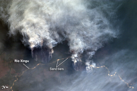 |
| Fires along the Rio Xingu, Brazil The rain forest of South America, also known as "Amazonia"--the largest such forest on Earth--has been undergoing a continual and accelerated land use conversion process into farmlands (including pasture for livestock) since the early 1960s. This process has typically been achieved by clearing of the forest using fire - "slash and burn" - followed by planting of crops. The generally infertile soils of the region make sustainable farming difficult; this drives more forest conversion into new farmland. The area of clearing can be considerable, and as the deforested regions are easily identifiable and measurable from space the rate of deforestation is likewise easy to track. This detailed astronaut photograph illustrates slash-and-burn forest clearing along the Xingu River (Rio) in the northeast of the state of Matto Grasso, Brazil. The image was taken from the International Space Station, a platform from which astronauts can take imagery of the Earth from a variety of viewing angles. The perspective of this image allows for a striking visualization of both the horizontal position and extent of the fire lines next to the river, as well as providing a sense of the vertical structure of the smoke plumes due to the viewing angle and shadowing. Light colored areas within the river channel are sand bars, which show that the river is in its annual low-flow/ low water stage. For a sense of scale, the Xingu River channel within the view is approximately 63 kilometers long. Rivers in Amazonia are its natural highways, which may explain why the burning is occurring right next to the Xingu River, one of Amazonia's largest. In recent years, preservation has gained traction in the region as a result of such considerations as new valuation of the ecosystem services provided by the forest, concerns about the impact of widespread burning on global climate change, and greater sensitivity to the ethnic and biological heritage of Amazonia. |
| Images: | All Available Images Low-Resolution 161k |
|
| Mission: | ISS029 |
|
| Roll - Frame: | E - 8032 |
|
| Geographical Name: | BRAZIL |
|
| Features: | RIO XINGU,FOREST,AMAZONIA,SMOKE PLUMES |
|
| Center Lat x Lon: | 11.8S x 53.6W |
|
| Film Exposure: | N=Normal exposure, U=Under exposed, O=Over exposed, F=out of Focus |
|
| Percentage of Cloud Cover-CLDP: | 10 |
|
| Camera:: | N2 |
|
| Camera Tilt: | 28 | LO=Low Oblique, HO=High Oblique, NV=Near Vertical |
| Camera Focal Length: | 200 |
|
| Nadir to Photo Center Direction: | NE | The direction from the nadir to the center point, N=North, S=South, E=East, W=West |
| Stereo?: | Y=Yes there is an adjacent picture of the same area, N=No there isn't |
|
| Orbit Number: | 1537 |
|
| Date: | 20110917 | YYYYMMDD |
| Time: | 201303 | GMT HHMMSS |
| Nadir Lat: | 12.8S |
Latitude of suborbital point of spacecraft |
| Nadir Lon: | 55.1W |
Longitude of suborbital point of spacecraft |
| Sun Azimuth: | 277 | Clockwise angle in degrees from north to the sun measured at the nadir point |
| Space Craft Altitude: | 205 | nautical miles |
| Sun Elevation: | 19 | Angle in degrees between the horizon and the sun, measured at the nadir point |
| Land Views: | FOREST |
|
| Water Views: | CHANNEL, RIVER |
|
| Atmosphere Views: | SMOKE |
|
| Man Made Views: | DEFORESTATION |
|
| City Views: | |
|
Photo is not associated with any sequences | ||
| NASA Home Page |
JSC Home Page |
JSC Digital Image Collection |
Earth Science & Remote Sensing |
|
This service is provided by the International Space Station program and the JSC Earth Science & Remote Sensing Unit, ARES Division, Exploration Integration Science Directorate.

|