
Geographic Region: USA-NEVADA
Feature: PAN-BASIN AND RANGE GEOLOGIC PROVINCE,SIERRA NEVADA,LAS VEGAS
|
Geographic Region: USA-NEVADA Feature: PAN-BASIN AND RANGE GEOLOGIC PROVINCE,SIERRA NEVADA,LAS VEGAS |
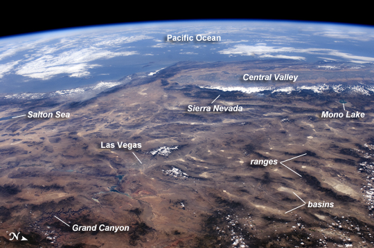 |
| ISS View of the Southwestern USA This panoramic view of the southwestern United States and Pacific Ocean was taken by an astronaut looking out at an angle from the International Space Station (ISS). While most unmanned satellites view the Earth from a nadir perspective--collecting data while looking "straight down"--astronauts onboard the ISS can acquire imagery at a wide range of viewing angles using handheld digital cameras. The ISS nadir point--the point on Earth's surface directly below the spacecraft--was located in northwestern Arizona, approximately 260 kilometers (160 miles) to the east-southeast, when this image was taken. The image includes parts of Arizona, Nevada, Utah, and California, as well the coastline of Baja California, Mexico (image center left). The Las Vegas metropolitan area appears as a gray region adjacent to the Spring Mountains and Sheep Range (both covered by white clouds). The Grand Canyon, located on the Colorado Plateau in Arizona, is visible to the east of Las Vegas, with the blue waters of Lake Meadin between. The image also includes the Mojave Desert, stretching north from the Salton Sea to the Sierra Nevada mountain range. The Sierra Nevada is roughly 640 km long (north-south) and forms the boundary between the Central Valley of California and the adjacent Basin and Range physiographic province. The Basin and Range is so called because of the pattern of long linear valleys separated by parallel mountain ranges. The landscape was formed by extension and thinning of the Earth's crust. |
| Images: | All Available Images Low-Resolution 223k |
|
| Mission: | ISS024 |
|
| Roll - Frame: | E - 14071 |
|
| Geographical Name: | USA-NEVADA |
|
| Features: | PAN-BASIN AND RANGE GEOLOGIC PROVINCE,SIERRA NEVADA,LAS VEGAS |
|
| Center Lat x Lon: | 36.5N x 116W |
|
| Film Exposure: | N=Normal exposure, U=Under exposed, O=Over exposed, F=out of Focus |
|
| Percentage of Cloud Cover-CLDP: | 10 |
|
| Camera:: | N2 |
|
| Camera Tilt: | 42 | LO=Low Oblique, HO=High Oblique, NV=Near Vertical |
| Camera Focal Length: | 32 |
|
| Nadir to Photo Center Direction: | W | The direction from the nadir to the center point, N=North, S=South, E=East, W=West |
| Stereo?: | Y=Yes there is an adjacent picture of the same area, N=No there isn't |
|
| Orbit Number: | 3679 |
|
| Date: | 20100909 | YYYYMMDD |
| Time: | 210823 | GMT HHMMSS |
| Nadir Lat: | 36.4N |
Latitude of suborbital point of spacecraft |
| Nadir Lon: | 113.2W |
Longitude of suborbital point of spacecraft |
| Sun Azimuth: | 222 | Clockwise angle in degrees from north to the sun measured at the nadir point |
| Space Craft Altitude: | 187 | nautical miles |
| Sun Elevation: | 52 | Angle in degrees between the horizon and the sun, measured at the nadir point |
| Land Views: | BASIN, DESERT, MOUNTAIN, PLATEAU, VALLEY |
|
| Water Views: | LAKE, OCEAN, SEA |
|
| Atmosphere Views: | |
|
| Man Made Views: | |
|
| City Views: | LAS VEGAS |
|
Photo is not associated with any sequences | ||
| NASA Home Page |
JSC Home Page |
JSC Digital Image Collection |
Earth Science & Remote Sensing |
|
This service is provided by the International Space Station program and the JSC Earth Science & Remote Sensing Unit, ARES Division, Exploration Integration Science Directorate.

|