Geographic Region: FRANCE
Feature: LYON,TORINO,MARSEIILE,CITY LIGHTS,LIGUREAN SEA,SUNGLINT
|
Geographic Region: FRANCE Feature: LYON,TORINO,MARSEIILE,CITY LIGHTS,LIGUREAN SEA,SUNGLINT |
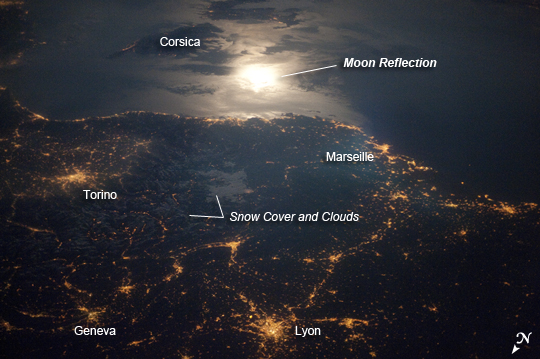 |
| City Lights at Night along the France-Italy Border The brightly lit metropolitan areas of Torino (Italy), Lyon, and Marseille (both in France) stand out amidst numerous smaller urban areas in this dramatic astronaut photograph. The image captures the nighttime appearance of the France-Italy border. The southwestern end of the Alps Mountains separates the two countries. The island of Corsica is visible in the Ligurian Sea to the south (image top). The full moon reflects brightly on the water surface and also illuminates the tops of low patchy clouds over the border (image center). This image was taken by an International Space Station (ISS) astronaut at approximately 11:55 p.m. local time, when the ISS was located over the France-Belgium border near Luxembourg. Astronauts orbiting the Earth frequently collect images that include sunglint, or the mirror-like reflection of sunlight off a water surface. Sunglint typically lends a bright, or washed out appearance to the water surface. In clear-sky conditions, reflected light from the Moon can produce the same effect (moonglint), as illustrated in this astronaut photograph. The astronaut observer was looking towards the southeast at an oblique viewing angle at the time the image was taken; in other words, looking outwards from the ISS, not straight down towards the Earth. |
| Images: | All Available Images Low-Resolution 219k |
|
| Mission: | ISS023 |
|
| Roll - Frame: | E - 29061 |
|
| Geographical Name: | FRANCE |
|
| Features: | LYON,TORINO,MARSEIILE,CITY LIGHTS,LIGUREAN SEA,SUNGLINT |
|
| Center Lat x Lon: | 44.5N x 5.5E |
|
| Film Exposure: | N=Normal exposure, U=Under exposed, O=Over exposed, F=out of Focus |
|
| Percentage of Cloud Cover-CLDP: | 10 |
|
| Camera:: | N3 |
|
| Camera Tilt: | HO | LO=Low Oblique, HO=High Oblique, NV=Near Vertical |
| Camera Focal Length: | 0 |
|
| Nadir to Photo Center Direction: | S | The direction from the nadir to the center point, N=North, S=South, E=East, W=West |
| Stereo?: | Y=Yes there is an adjacent picture of the same area, N=No there isn't |
|
| Orbit Number: | 1571 |
|
| Date: | 20100428 | YYYYMMDD |
| Time: | 215412 | GMT HHMMSS |
| Nadir Lat: | 49.5N |
Latitude of suborbital point of spacecraft |
| Nadir Lon: | 5.5E |
Longitude of suborbital point of spacecraft |
| Sun Azimuth: | 333 | Clockwise angle in degrees from north to the sun measured at the nadir point |
| Space Craft Altitude: | 188 | nautical miles |
| Sun Elevation: | -22 | Angle in degrees between the horizon and the sun, measured at the nadir point |
| Land Views: | ISLAND |
|
| Water Views: | SEA |
|
| Atmosphere Views: | |
|
| Man Made Views: | |
|
| City Views: | MARSEILLE, TORINO |
|
Photo is not associated with any sequences | ||
| NASA Home Page |
JSC Home Page |
JSC Digital Image Collection |
Earth Science & Remote Sensing |
|
This service is provided by the International Space Station program and the JSC Earth Science & Remote Sensing Unit, ARES Division, Exploration Integration Science Directorate.

|