Geographic Region: ATLANTIC OCEAN I(S).
Feature: ST HELENA I., JAMESTOWN, DIANA PK., FOR., RAVINES
|
Geographic Region: ATLANTIC OCEAN I(S). Feature: ST HELENA I., JAMESTOWN, DIANA PK., FOR., RAVINES |
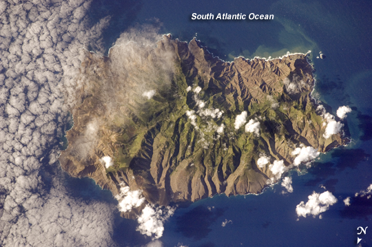 |
| Saint Helena Island Saint Helena Island, located in the South Atlantic Ocean approximately 1,860 kilometers (1,156 miles) west of Africa, was one of the many isolated islands that naturalist Charles Darwin visited during his scientific voyages in the nineteenth century. He visited the island in 1836 aboard the HMS Beagle, recording observations of the plants, animals, and geology that would shape his theory of evolution. This image was acquired by astronauts onboard the International Space Station as part of an ongoing effort (the HMS Beagle Project to document current biodiversity in areas visited by Charles Darwin. This astronaut photograph shows the island's sharp peaks and deep ravines; the rugged topography results from erosion of the volcanic rocks that make up the island. The change in elevation from the coast to the interior creates a climate gradient. The higher, wetter center is covered with green vegetation, whereas the lower coastal areas are drier and hotter, with little vegetation cover. Human presence on the island has also caused dramatic changes to the original plants and animals of the island. Only about 10 percent of the forest cover observed by the first explorers now remains in a semi-natural state, concentrated in the interior highlands. Saint Helena Island is perhaps best known as the final resting place of Napoleon Bonaparte I of France. Bonaparte was exiled to the island following his defeat at the Battle of Waterloo in 1815; he died on the island six years later in 1821. Today, the island is a British Overseas Territory, with access provided thirty times a year by a single ship, the Royal Mail Ship St. Helena. |
| Images: | All Available Images Low-Resolution 232k |
|
| Mission: | ISS019 |
|
| Roll - Frame: | E - 14918 |
|
| Geographical Name: | ATLANTIC OCEAN I(S). |
|
| Features: | ST HELENA I., JAMESTOWN, DIANA PK., FOR., RAVINES |
|
| Center Lat x Lon: | 16S x 5.7W |
|
| Film Exposure: | N=Normal exposure, U=Under exposed, O=Over exposed, F=out of Focus |
|
| Percentage of Cloud Cover-CLDP: | 25 |
|
| Camera:: | N2 |
|
| Camera Tilt: | 6 | LO=Low Oblique, HO=High Oblique, NV=Near Vertical |
| Camera Focal Length: | 400 |
|
| Nadir to Photo Center Direction: | SW | The direction from the nadir to the center point, N=North, S=South, E=East, W=West |
| Stereo?: | Y=Yes there is an adjacent picture of the same area, N=No there isn't |
|
| Orbit Number: | 3952 |
|
| Date: | 20090507 | YYYYMMDD |
| Time: | 083705 | GMT HHMMSS |
| Nadir Lat: | 15.7S |
Latitude of suborbital point of spacecraft |
| Nadir Lon: | 5.5W |
Longitude of suborbital point of spacecraft |
| Sun Azimuth: | 62 | Clockwise angle in degrees from north to the sun measured at the nadir point |
| Space Craft Altitude: | 193 | nautical miles |
| Sun Elevation: | 26 | Angle in degrees between the horizon and the sun, measured at the nadir point |
| Land Views: | EROSION, FOREST, ISLAND |
|
| Water Views: | OCEAN |
|
| Atmosphere Views: | |
|
| Man Made Views: | |
|
| City Views: | |
|
Photo is not associated with any sequences | ||
| NASA Home Page |
JSC Home Page |
JSC Digital Image Collection |
Earth Science & Remote Sensing |
|
This service is provided by the International Space Station program and the JSC Earth Science & Remote Sensing Unit, ARES Division, Exploration Integration Science Directorate.

|