Geographic Region: SUDAN
Feature: MARRA MTS., DERIBA CRATER, L.
|
Geographic Region: SUDAN Feature: MARRA MTS., DERIBA CRATER, L. |
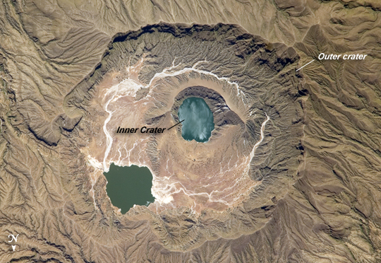 |
| Deriba Caldera, Sudan Deriba Caldera is a geologically young volcanic structure located at the top of the Marra Mountains of western Sudan. The Marra Mountains are part of a large geologic feature known as the Darfur Dome. The dome appears to be the result of a mantle plume, which is a fixed "hotspot" in the Earth's mantle (the layer of Earth below the crust). The mantle plume heated the crust from below, leading to uplift of the crust and providing a magma source for the extensive volcanism observed in the region. The 5-kilometer-wide Deriba Caldera was formed by explosive eruption of the Jebel Marra Volcano approximately 3,500 years ago. The volcano is considered dormant, rather than extinct, as hot springs and fumaroles (gas and steam vents) are still present. The caldera has the classic shape: it formed as overlying rock and soil collapsed into the magma chamber after it was emptied by powerful eruptions. Shadows in this astronaut photograph throw the steep southern wall of the outer crater into sharp relief. Following the formation of the main outer crater, a second inner crater (image center) formed, most likely due to later uplift and eruption of fresh magma moving towards the surface. This inner crater is filled with water. Because the walls of the inner crater are higher than the adjacent caldera floor, precipitation flowing inwards from the outer crater walls do not enter the inner crater lake. White stream bed sediments (image center) show the water pathway around the inner crater to a second lake located along the northeast wall of the outer crater. While Jebel Marra is high enough (3,042 meters) to have a temperate climate and high precipitation, these lakes may be fed by hot springs as well as rainwater. The inner crater lake has a mottled appearance caused by sunglint--light reflected off a roughened water surface back towards the astronaut onboard the International Space Station. |
| Images: | All Available Images Low-Resolution 304k |
|
| Mission: | ISS018 |
|
| Roll - Frame: | E - 6051 |
|
| Geographical Name: | SUDAN |
|
| Features: | MARRA MTS., DERIBA CRATER, L. |
|
| Center Lat x Lon: | 13.0N x 24.3E |
|
| Film Exposure: | N=Normal exposure, U=Under exposed, O=Over exposed, F=out of Focus |
|
| Percentage of Cloud Cover-CLDP: | 10 |
|
| Camera:: | N2 |
|
| Camera Tilt: | 16 | LO=Low Oblique, HO=High Oblique, NV=Near Vertical |
| Camera Focal Length: | 800 |
|
| Nadir to Photo Center Direction: | SW | The direction from the nadir to the center point, N=North, S=South, E=East, W=West |
| Stereo?: | Y=Yes there is an adjacent picture of the same area, N=No there isn't |
|
| Orbit Number: | 965 |
|
| Date: | 20081029 | YYYYMMDD |
| Time: | 101619 | GMT HHMMSS |
| Nadir Lat: | 13.7N |
Latitude of suborbital point of spacecraft |
| Nadir Lon: | 24.9E |
Longitude of suborbital point of spacecraft |
| Sun Azimuth: | 186 | Clockwise angle in degrees from north to the sun measured at the nadir point |
| Space Craft Altitude: | 190 | nautical miles |
| Sun Elevation: | 63 | Angle in degrees between the horizon and the sun, measured at the nadir point |
| Land Views: | CALDERA, CRATER, VOLCANO |
|
| Water Views: | LAKE, SUNGLINT |
|
| Atmosphere Views: | |
|
| Man Made Views: | |
|
| City Views: | |
|
Photo is not associated with any sequences | ||
| NASA Home Page |
JSC Home Page |
JSC Digital Image Collection |
Earth Science & Remote Sensing |
|
This service is provided by the International Space Station program and the JSC Earth Science & Remote Sensing Unit, ARES Division, Exploration Integration Science Directorate.

|