
Geographic Region: CANADA-O
Feature: THUNDER BAY,SNOW
|
Geographic Region: CANADA-O Feature: THUNDER BAY,SNOW |
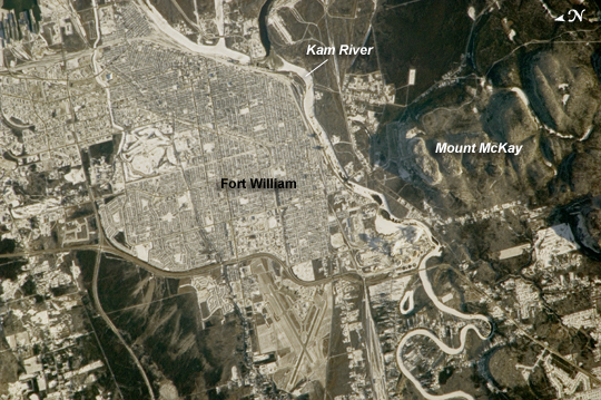 |
| City of Thunder Bay, Ontario, Canada Located on the shores of Lake Superior (regional view), the metropolitan area of Thunder Bay is one of the largest in the Province of Ontario. It is also the major port providing access to the Great Lakes for central Canada's grain products. The city of Thunder Bay is relatively new; it was incorporated in 1970 by combining the cities of Fort William (shown in this astronaut photograph) and Port Arthur with the townships of Neebing and McIntyre. While the spread of separate municipalities into a larger contiguous metropolitan area is common (urban geographers call the process agglomeration), it is less common for distinct cities to merge into a new political entity. This detailed astronaut photograph is centered on the older city of Fort William, in the southern portion of Thunder Bay. Winter snows outline the street grid of the city, while parks appear as roughly rectangular areas of unbroken white snow. Built materials (buildings, streets) appear light gray, while vegetated areas and the rock outcrop near Mount McKay are dark green to dark gray. The Kam River to the south of Fort William is ice-covered, and has an even covering of snow that traces the river channel. |
| Images: | All Available Images Low-Resolution 300k |
|
| Mission: | ISS018 |
|
| Roll - Frame: | E - 11174 |
|
| Geographical Name: | CANADA-O |
|
| Features: | THUNDER BAY,SNOW |
|
| Center Lat x Lon: | 48.4N x 89.3W |
|
| Film Exposure: | N=Normal exposure, U=Under exposed, O=Over exposed, F=out of Focus |
|
| Percentage of Cloud Cover-CLDP: | 10 |
|
| Camera:: | N2 |
|
| Camera Tilt: | 25 | LO=Low Oblique, HO=High Oblique, NV=Near Vertical |
| Camera Focal Length: | 800 |
|
| Nadir to Photo Center Direction: | SW | The direction from the nadir to the center point, N=North, S=South, E=East, W=West |
| Stereo?: | Y=Yes there is an adjacent picture of the same area, N=No there isn't |
|
| Orbit Number: | 1569 |
|
| Date: | 20081206 | YYYYMMDD |
| Time: | 191959 | GMT HHMMSS |
| Nadir Lat: | 49.3N |
Latitude of suborbital point of spacecraft |
| Nadir Lon: | 88.2W |
Longitude of suborbital point of spacecraft |
| Sun Azimuth: | 203 | Clockwise angle in degrees from north to the sun measured at the nadir point |
| Space Craft Altitude: | 185 | nautical miles |
| Sun Elevation: | 15 | Angle in degrees between the horizon and the sun, measured at the nadir point |
| Land Views: | |
|
| Water Views: | ICE, RIVER |
|
| Atmosphere Views: | |
|
| Man Made Views: | |
|
| City Views: | FORT WILLIAM |
|
Photo is not associated with any sequences | ||
| NASA Home Page |
JSC Home Page |
JSC Digital Image Collection |
Earth Science & Remote Sensing |
|
This service is provided by the International Space Station program and the JSC Earth Science & Remote Sensing Unit, ARES Division, Exploration Integration Science Directorate.

|