Geographic Region: LIBYA
Feature: DESERT,DENDRITIC DRAINAGE
|
Geographic Region: LIBYA Feature: DESERT,DENDRITIC DRAINAGE |
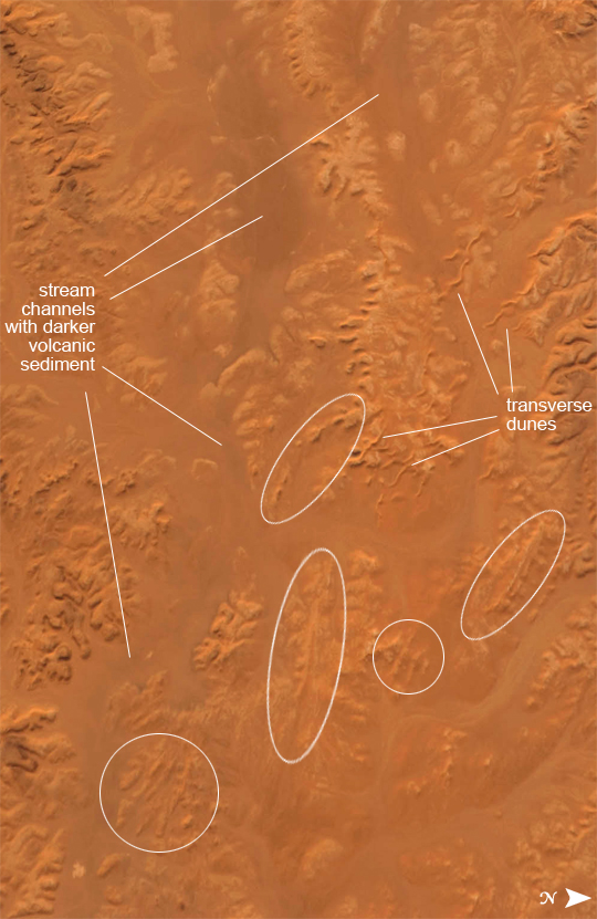 |
| Desert Erosion, A Modern Libyan Landscape This detailed astronaut photograph shows the classic patterns of an eroded desert landscape, about 300 kilometers (190 miles) south of Libya's Mediterranean coast. Widespread indented patterns are low escarpments and stream terraces generated by stream erosion--on those few occasions in any decade when enough rain falls for streams to flow. The only areas where sediment is being deposited are the streambeds, which appear in this image as sinuous zones with a distinct component of black minerals. These minerals give the streambeds a darker color than adjacent low escarpments (image top left and lower left). The sediment comes from a volcanic landscape immediately upstream to the west. Other stream-generated features are several relict stream banks (indicated by ovals); one area even preserves both (parallel) banks of the original stream (far right oval). The ancient stream banks were cemented by minerals such as calcium carbonate and gypsum, introduced by the streams when they were active, probably during wetter climates in the past 2 million years. Relict stream courses show prior positions of streams, and help tell the region's paleoclimate story. They also provide Earth analogs for similar features on Mars. The lack of vegetation is the first indication of the great aridity of the region, but sand dunes also appear as sinuous lines oriented perpendicular to the dominant northeasterly wind direction (transverse dunes). If the dominant wind direction remains the same, these transverse dunes would be expected to move further to the southwest over time (towards the top left). Some of the dunes cross the river courses, showing how seldom the rivers flow. |
| Images: | All Available Images Low-Resolution 333k |
|
| Mission: | ISS017 |
|
| Roll - Frame: | E - 13789 |
|
| Geographical Name: | LIBYA |
|
| Features: | DESERT,DENDRITIC DRAINAGE |
|
| Center Lat x Lon: | 28.3N x 16.2E |
|
| Film Exposure: | N=Normal exposure, U=Under exposed, O=Over exposed, F=out of Focus |
|
| Percentage of Cloud Cover-CLDP: | 10 |
|
| Camera:: | N2 |
|
| Camera Tilt: | 24 | LO=Low Oblique, HO=High Oblique, NV=Near Vertical |
| Camera Focal Length: | 400 |
|
| Nadir to Photo Center Direction: | SW | The direction from the nadir to the center point, N=North, S=South, E=East, W=West |
| Stereo?: | Y=Yes there is an adjacent picture of the same area, N=No there isn't |
|
| Orbit Number: | 3851 |
|
| Date: | 20080819 | YYYYMMDD |
| Time: | 143609 | GMT HHMMSS |
| Nadir Lat: | 29.5N |
Latitude of suborbital point of spacecraft |
| Nadir Lon: | 17.0E |
Longitude of suborbital point of spacecraft |
| Sun Azimuth: | 264 | Clockwise angle in degrees from north to the sun measured at the nadir point |
| Space Craft Altitude: | 191 | nautical miles |
| Sun Elevation: | 36 | Angle in degrees between the horizon and the sun, measured at the nadir point |
| Land Views: | DESERT, EROSION |
|
| Water Views: | SEDIMENT |
|
| Atmosphere Views: | |
|
| Man Made Views: | |
|
| City Views: | |
|
Photo is not associated with any sequences | ||
| NASA Home Page |
JSC Home Page |
JSC Digital Image Collection |
Earth Science & Remote Sensing |
|
This service is provided by the International Space Station program and the JSC Earth Science & Remote Sensing Unit, ARES Division, Exploration Integration Science Directorate.

|