Geographic Region: GREENLAND
Feature: PAN-C. FAREWELL, ICE CAP, GL.
|
Geographic Region: GREENLAND Feature: PAN-C. FAREWELL, ICE CAP, GL. |
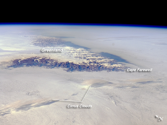 |
| Cape Farewell, Greenland Greenland is the world's largest island, with an area of over 2 million square kilometers; however, much of the island is covered by an ice cap that can reach thicknesses of 3 kilometers. This astronaut photograph illustrates the southernmost tip of Greenland, known as Kap Farvel in Danish and Nunap Isua in Inuit. The viewing direction is towards the northeast; the image was taken when the International Space Station was located near its most northerly orbital latitude of 52 degrees. The northern coast of Newfoundland was approximately 1,160 kilometers to the southwest. The image is highly oblique--taken from an angle looking outwards from the ISS, rather than straight down towards the Earth--and this perspective provides a sense of topography along the southern edge of Greenland. The exposed dark grey bedrock along the southwestern coastline has been carved by glaciers into numerous fjords, steep-sided valleys that drain directly into the ocean. The white cloud cover surrounding the island likely mingles with some sea ice and icebergs calved from glaciers. A band of high-altitude cirrus clouds (light grey) casts shadows on the lower stratus cloud deck in the lower third of the image. The thin blue layer of Earth's atmosphere is visible spanning the top third of the image from left to right. |
| Images: | All Available Images Low-Resolution 160k |
|
| Mission: | ISS017 |
|
| Roll - Frame: | E - 12583 |
|
| Geographical Name: | GREENLAND |
|
| Features: | PAN-C. FAREWELL, ICE CAP, GL. |
|
| Center Lat x Lon: | 60.0N x 44.5W |
|
| Film Exposure: | N=Normal exposure, U=Under exposed, O=Over exposed, F=out of Focus |
|
| Percentage of Cloud Cover-CLDP: | 100 |
|
| Camera:: | N2 |
|
| Camera Tilt: | HO | LO=Low Oblique, HO=High Oblique, NV=Near Vertical |
| Camera Focal Length: | 70 |
|
| Nadir to Photo Center Direction: | NE | The direction from the nadir to the center point, N=North, S=South, E=East, W=West |
| Stereo?: | Y=Yes there is an adjacent picture of the same area, N=No there isn't |
|
| Orbit Number: | 3619 |
|
| Date: | 20080804 | YYYYMMDD |
| Time: | 202453 | GMT HHMMSS |
| Nadir Lat: | 51.3N |
Latitude of suborbital point of spacecraft |
| Nadir Lon: | 54.5W |
Longitude of suborbital point of spacecraft |
| Sun Azimuth: | 266 | Clockwise angle in degrees from north to the sun measured at the nadir point |
| Space Craft Altitude: | 183 | nautical miles |
| Sun Elevation: | 25 | Angle in degrees between the horizon and the sun, measured at the nadir point |
| Land Views: | CAPE, COAST, ISLAND |
|
| Water Views: | ICE, SEA ICE, OCEAN |
|
| Atmosphere Views: | |
|
| Man Made Views: | |
|
| City Views: | |
|
Photo is not associated with any sequences | ||
| NASA Home Page |
JSC Home Page |
JSC Digital Image Collection |
Earth Science & Remote Sensing |
|
This service is provided by the International Space Station program and the JSC Earth Science & Remote Sensing Unit, ARES Division, Exploration Integration Science Directorate.

|