Geographic Region: NICARAGUA
Feature: CONCEPCION VOLCANO,PLUME
|
Geographic Region: NICARAGUA Feature: CONCEPCION VOLCANO,PLUME |
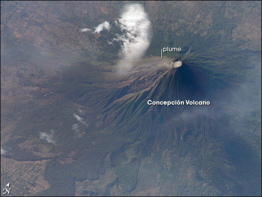 |
| Concepcion Volcano, Nicaragua: Concepcion Volcano is one of the tallest and most active of Nicaragua's volcanoes. The 1,610-meter (5,280-foot), cone-shaped volcano is the northern half of dumbbell-shaped Isla de Ometepe. Concepcion is joined by a narrow isthmus to the dormant Maderas Volcano, which makes up the southern half of the island. This image of the volcano was captured on May 10, 2007, by the astronauts onboard the International Space Station. To the northwest of the crater, a very faint plume (probably steam) creeps like fog down the mountain, blurring the sharp gullies that carve the volcano's flanks. The grid pattern of people's fields surrounds the volcano, while lobes of forest line the lower slopes. Concepcion has erupted at least 25 times in the past 125 years, but eruptions are not the only hazard for the 5,000 or so people who lives in small towns at lower elevations. Loose rock and ash from previous eruptions makes the volcano's steep slopes unstable and prone to give way during heavy rains. These flows of muddy debris are known as lahars. Among the most serious lahars that have occurred at Concepcion in recent years were those that occurred during the passage of Hurricane Mitch through the area in 1998. (Much more serious lahars occurred at Nicaragua's Casita Volcano during Hurricane Mitch.) The gullies that can funnel debris quickly downslope into populated areas are obvious in the image. References and Related images: "Lahar Hazards at Concepcion Volcano, Nicaragua" (formerly found at https://vulcan.wr.usgs.gov/Volcanoes/Nicaragua/Publications/OFR01-457/framework.html), a U.S. Geological Survey Webpage Wide-area view of western Nicaragua, including Lake Nicaragua and Isla Ometepe at lower right, from the Moderate Resolution Imaging Spectroradiometer (MODIS) on NASA's Terra satellite |
| Images: | All Available Images Low-Resolution 76k |
|
| Mission: | ISS015 |
|
| Roll - Frame: | E - 7543 |
|
| Geographical Name: | NICARAGUA |
|
| Features: | CONCEPCION VOLCANO,PLUME |
|
| Center Lat x Lon: | 11.5N x 85.6W |
|
| Film Exposure: | N=Normal exposure, U=Under exposed, O=Over exposed, F=out of Focus |
|
| Percentage of Cloud Cover-CLDP: | 10 |
|
| Camera:: | E4 |
|
| Camera Tilt: | HO | LO=Low Oblique, HO=High Oblique, NV=Near Vertical |
| Camera Focal Length: | 800 |
|
| Nadir to Photo Center Direction: | NW | The direction from the nadir to the center point, N=North, S=South, E=East, W=West |
| Stereo?: | Y=Yes there is an adjacent picture of the same area, N=No there isn't |
|
| Orbit Number: | 488 |
|
| Date: | 20070510 | YYYYMMDD |
| Time: | 214329 | GMT HHMMSS |
| Nadir Lat: | 6.5N |
Latitude of suborbital point of spacecraft |
| Nadir Lon: | 82.8W |
Longitude of suborbital point of spacecraft |
| Sun Azimuth: | 287 | Clockwise angle in degrees from north to the sun measured at the nadir point |
| Space Craft Altitude: | 178 | nautical miles |
| Sun Elevation: | 27 | Angle in degrees between the horizon and the sun, measured at the nadir point |
| Land Views: | CRATER, FOREST, ISLAND, MOUNTAIN, VOLCANO |
|
| Water Views: | |
|
| Atmosphere Views: | PLUME |
|
| Man Made Views: | |
|
| City Views: | |
|
Photo is not associated with any sequences | ||
| NASA Home Page |
JSC Home Page |
JSC Digital Image Collection |
Earth Science & Remote Sensing |
|
This service is provided by the International Space Station program and the JSC Earth Science & Remote Sensing Unit, ARES Division, Exploration Integration Science Directorate.

|