Geographic Region: CANARY ISLANDS
Feature: TEIDE VOLCANO,TENERIFE
|
Geographic Region: CANARY ISLANDS Feature: TEIDE VOLCANO,TENERIFE |
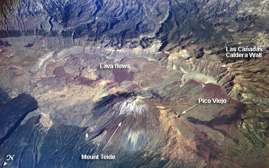 |
| ISS013-E-23272 (8 June 2006) --- Tenerife Island, Spain is featured in this image photographed by an Expedition 13 crewmember on the International Space Station. Tenerife is the largest of the Canary Islands, a Spanish possession located off the northwestern coast of Africa. According to scientists, the islands in the chain could have been produced by eruptions of basaltic shield volcanoes as the African tectonic plate moved over a stationary "hot spot" much like the formation of the Hawaiian Islands. A different hypothesis relates the Canary Islands to magma rise along underwater faults during the uplift of the Atlas Mountains in northern Africa. The island of Tenerife exhibits many excellent volcanic features. The central feature of this image is the elliptical depression of the Las Ca?adas caldera that measures 170 square kilometers in area. A caldera is typically formed when the magma chamber underneath a volcano is completely emptied (usually following a massive eruptive event), and the overlying materials collapse into the newly formed void beneath the surface. A large landslide may have also contributed to (or been the primary cause of) formation of the caldera structure. In this model, part of the original shield volcano forming the bedrock of the island collapsed onto the adjacent sea floor, forming the large depression of the caldera. According to scientists, following formation of the caldera approximately 0.17 million years ago, the composite volcanoes of Mount Teide and Pico Viejo formed. Teide is the highest peak in the Atlantic Ocean with a summit elevation of 3,715 meters. This type of volcano is formed by alternating layers of dense lava flows and more fragmented explosive eruption products, and can build high cones. Many linear flow levees are visible along the flanks of Teide volcano extending from the summit to the base, while a large circular explosion crater marks the summit of Pico Viejo. The floor of the Las Ca?adas caldera is covered with tan, red-brown, and black irregularly-lobed lava flows, the eruptions of which have been observed by settlers and seamen since 1402. The most recent eruption occurred in 1909. The island of Tenerife is actively monitored for further activity. |
| Images: | All Available Images Low-Resolution 309k |
|
| Mission: | ISS013 |
|
| Roll - Frame: | E - 23272 |
|
| Geographical Name: | CANARY ISLANDS |
|
| Features: | TEIDE VOLCANO,TENERIFE |
|
| Center Lat x Lon: | 28.3N x 16.6W |
|
| Film Exposure: | N=Normal exposure, U=Under exposed, O=Over exposed, F=out of Focus |
|
| Percentage of Cloud Cover-CLDP: | 10 |
|
| Camera:: | E4 |
|
| Camera Tilt: | HO | LO=Low Oblique, HO=High Oblique, NV=Near Vertical |
| Camera Focal Length: | 800 |
|
| Nadir to Photo Center Direction: | SE | The direction from the nadir to the center point, N=North, S=South, E=East, W=West |
| Stereo?: | Y=Yes there is an adjacent picture of the same area, N=No there isn't |
|
| Orbit Number: | 2883 |
|
| Date: | 20060520 | YYYYMMDD |
| Time: | 172928 | GMT HHMMSS |
| Nadir Lat: | 31.3N |
Latitude of suborbital point of spacecraft |
| Nadir Lon: | 20.3W |
Longitude of suborbital point of spacecraft |
| Sun Azimuth: | 275 | Clockwise angle in degrees from north to the sun measured at the nadir point |
| Space Craft Altitude: | 183 | nautical miles |
| Sun Elevation: | 33 | Angle in degrees between the horizon and the sun, measured at the nadir point |
| Land Views: | CALDERA, CRATER, ISLAND, VOLCANO |
|
| Water Views: | |
|
| Atmosphere Views: | |
|
| Man Made Views: | |
|
| City Views: | |
|
Photo is not associated with any sequences | ||
| NASA Home Page |
JSC Home Page |
JSC Digital Image Collection |
Earth Science & Remote Sensing |
|
This service is provided by the International Space Station program and the JSC Earth Science & Remote Sensing Unit, ARES Division, Exploration Integration Science Directorate.

|