
Geographic Region: USA-DC
Feature: WASHINGTON METRO AREA
|
Geographic Region: USA-DC Feature: WASHINGTON METRO AREA |
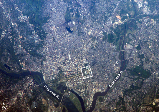 |
| Washington, D.C. George Washington not only served as the namesake for the capital city of the United States, he also chose its location, perhaps envisioning the transportation possibilities that the Potomac River flowing past the site would provide. Early on, the city saw conflict; in the War of 1812, British forces invaded and burned several public buildings. The Civil War marked the beginning of the city's transformation from a provincial town to a world center of culture, history, and political energy during the 20th century. According to the Census Bureau, the District of Columbia, which comprises the city of Washington, supported a population of more than half a million inhabitants in 2003. This picture was taken as the International Space Station passed over the western border of Maryland and West Virginia. The resolution and spatial coverage of this image are similar to the 15-meter-per-pixel data obtained by sensors onboard the Landsat 7 and Terra satellites. Recognizable in this image are the Capitol Building, the Washington Monument (and its shadow), and the Lincoln Memorial, along the northeast bank of the Potomac River. |
| Images: | All Available Images Low-Resolution 378k |
|
| Mission: | ISS013 |
|
| Roll - Frame: | E - 13549 |
|
| Geographical Name: | USA-DC |
|
| Features: | WASHINGTON METRO AREA |
|
| Center Lat x Lon: | 38.9N x 77W |
|
| Film Exposure: | N=Normal exposure, U=Under exposed, O=Over exposed, F=out of Focus |
|
| Percentage of Cloud Cover-CLDP: | 10 |
|
| Camera:: | E4 |
|
| Camera Tilt: | 41 | LO=Low Oblique, HO=High Oblique, NV=Near Vertical |
| Camera Focal Length: | 800 |
|
| Nadir to Photo Center Direction: | E | The direction from the nadir to the center point, N=North, S=South, E=East, W=West |
| Stereo?: | Y=Yes there is an adjacent picture of the same area, N=No there isn't |
|
| Orbit Number: | 2602 |
|
| Date: | 20060502 | YYYYMMDD |
| Time: | 211823 | GMT HHMMSS |
| Nadir Lat: | 39.3N |
Latitude of suborbital point of spacecraft |
| Nadir Lon: | 79.6W |
Longitude of suborbital point of spacecraft |
| Sun Azimuth: | 264 | Clockwise angle in degrees from north to the sun measured at the nadir point |
| Space Craft Altitude: | 184 | nautical miles |
| Sun Elevation: | 32 | Angle in degrees between the horizon and the sun, measured at the nadir point |
| Land Views: | |
|
| Water Views: | RIVER |
|
| Atmosphere Views: | |
|
| Man Made Views: | |
|
| City Views: | COLUMBIA, LINCOLN, WASHINGTON |
|
Photo is not associated with any sequences | ||
| NASA Home Page |
JSC Home Page |
JSC Digital Image Collection |
Earth Science & Remote Sensing |
|
This service is provided by the International Space Station program and the JSC Earth Science & Remote Sensing Unit, ARES Division, Exploration Integration Science Directorate.

|