Geographic Region: NETHERLANDS
Feature: EUROPOORT, HARBOR, SHIPS, AGR.
|
Geographic Region: NETHERLANDS Feature: EUROPOORT, HARBOR, SHIPS, AGR. |
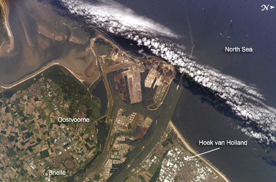 |
| Port of Rotterdam, Netherlands The Port of Rotterdam, also known as Europoort (Eurogate), has been an important trading center since approximately AD 1250. The history of the port reflects the evolution of the world's economic base. Originally serving the North Sea herring fleets, it rapidly grew into a major mercantile port during the Dutch colonial period. The 19th century witnessed the Industrial Revolution, and steel and coal became major commodities passing through the port. Following the development of petroleum as a primary energy resource in the early twentieth century, the port expanded westward to accommodate storage facilities and large oil tankers. This westward expansion continued beyond the coastline in the 1970s, when a portion of the sea was cordoned off and drained to create the facilities visible in this astronaut photograph. Large petroleum storage tank fields and docks for supertankers occupy the center of the image. In 2004, more than 350 million tons of cargo passed through the port. The image illustrates the close proximity of the Europoort to the surrounding cities of Hoek van Holland, Oostvoorne, Brielle. Between Oostvoorne and Brielle, a mixture of fertile and fallow agricultural fields create a green and tan checkboard. The presence of the port and its seawalls interrupts southward-flowing coastal currents, leading to accumulation of sediment to the south (lower left of image). Numerous ship wakes are visible within the port complex itself and in the North Sea, in the upper part of the image. |
| Images: | All Available Images Low-Resolution 255k |
|
| Mission: | ISS011 |
|
| Roll - Frame: | E - 7380 |
|
| Geographical Name: | NETHERLANDS |
|
| Features: | EUROPOORT, HARBOR, SHIPS, AGR. |
|
| Center Lat x Lon: | 52.0N x 4.1E |
|
| Film Exposure: | N=Normal exposure, U=Under exposed, O=Over exposed, F=out of Focus |
|
| Percentage of Cloud Cover-CLDP: | 10 |
|
| Camera:: | E4 |
|
| Camera Tilt: | 33 | LO=Low Oblique, HO=High Oblique, NV=Near Vertical |
| Camera Focal Length: | 400 |
|
| Nadir to Photo Center Direction: | W | The direction from the nadir to the center point, N=North, S=South, E=East, W=West |
| Stereo?: | Y=Yes there is an adjacent picture of the same area, N=No there isn't |
|
| Orbit Number: | 1259 |
|
| Date: | 20050528 | YYYYMMDD |
| Time: | 130433 | GMT HHMMSS |
| Nadir Lat: | 51.8N |
Latitude of suborbital point of spacecraft |
| Nadir Lon: | 6.1E |
Longitude of suborbital point of spacecraft |
| Sun Azimuth: | 219 | Clockwise angle in degrees from north to the sun measured at the nadir point |
| Space Craft Altitude: | 187 | nautical miles |
| Sun Elevation: | 55 | Angle in degrees between the horizon and the sun, measured at the nadir point |
| Land Views: | |
|
| Water Views: | SEA, SEDIMENT |
|
| Atmosphere Views: | |
|
| Man Made Views: | PORT |
|
| City Views: | ROTTERDAM |
|
Photo is not associated with any sequences | ||
| NASA Home Page |
JSC Home Page |
JSC Digital Image Collection |
Earth Science & Remote Sensing |
|
This service is provided by the International Space Station program and the JSC Earth Science & Remote Sensing Unit, ARES Division, Exploration Integration Science Directorate.

|