
Geographic Region: USA-MASSACHUSETTS
Feature: BUZZARDS BAY,WAREHAM
|
Geographic Region: USA-MASSACHUSETTS Feature: BUZZARDS BAY,WAREHAM |
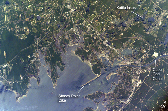 |
| Buzzards Bay, Massachusetts The latter portion of the Pleistocene Epoch in New England saw the creation of Buzzards Bay through the interplay of glacial and oceanic processes. Beginning approximately 50,000-70,000 years ago, the edges of the continental ice sheet covering much of northern North America began to fluctuate, leaving linear masses of gravel, sand, and silt (known as moraines) to mark former extents of the ice. One such moraine forms most of the eastern shoreline of Buzzards Bay visible in this astronaut photograph. In addition to the moraines, the melting ice sheet produced extensive plains of outwash composed of mixed sediments and ice that bordered the bay to the northwest and west. Melting ice blocks in the outwash deposits formed distinctive circular features called kettle lakes (or holes). Numerous examples of kettle lakes are visible to the northwest of the Cape Cod Canal. Finally, waters released from the melting ice sheet raised sea level by 60-120 meters (198-396 feet) and drowned preexisting outwash channels (visible as linear embayments along the western shoreline). Buzzards Bay attained its broad current configuration approximately 15,000 years ago; the current sea level was present approximately 3,500 years ago. The modern Buzzards Bay is approximately 45 kilometers (28 miles) long by 12 kilometers (8 miles) wide and is a popular destination for fishing, boating, and tourism. The Cape Cod Canal allows for passage between Buzzards Bay and Cape Cod Bay to the northeast (not visible); the wakes of numerous pleasure craft appear along the length of the Canal. The combination of shallow depth, tidal action and surface waves promotes mixing of the estuarine waters leading to a productive aquatic ecosystem. The dynamic nature of the Bay's waters are visible in this astronaut photograph as surface wave reflectance patterns around Stoney Point Dike and in the kettle lakes. Like many estuaries, however, increasing development and land-use change by the surrounding communities are accompanied by nutrient runoff leading to eutrophication (an increase in nutrient levels leading to oxygen depletion) in the smaller embayments. Decreases in eelgrass, scallops, and herring have also been noted, but direct cause-and-effect relationships are not clear. Coordinated management efforts in Buzzards Bay have helped to decrease shellfish closures, conserve habitat for sea birds, and preserve open space. |
| Images: | All Available Images Low-Resolution 315k |
|
| Mission: | ISS011 |
|
| Roll - Frame: | E - 10856 |
|
| Geographical Name: | USA-MASSACHUSETTS |
|
| Features: | BUZZARDS BAY,WAREHAM |
|
| Center Lat x Lon: | 41.7N x 70.7W |
|
| Film Exposure: | N=Normal exposure, U=Under exposed, O=Over exposed, F=out of Focus |
|
| Percentage of Cloud Cover-CLDP: | 10 |
|
| Camera:: | E4 |
|
| Camera Tilt: | 2 | LO=Low Oblique, HO=High Oblique, NV=Near Vertical |
| Camera Focal Length: | 400 |
|
| Nadir to Photo Center Direction: | E | The direction from the nadir to the center point, N=North, S=South, E=East, W=West |
| Stereo?: | Y=Yes there is an adjacent picture of the same area, N=No there isn't |
|
| Orbit Number: | 2127 |
|
| Date: | 20050722 | YYYYMMDD |
| Time: | 165514 | GMT HHMMSS |
| Nadir Lat: | 41.7N |
Latitude of suborbital point of spacecraft |
| Nadir Lon: | 70.8W |
Longitude of suborbital point of spacecraft |
| Sun Azimuth: | 184 | Clockwise angle in degrees from north to the sun measured at the nadir point |
| Space Craft Altitude: | 188 | nautical miles |
| Sun Elevation: | 69 | Angle in degrees between the horizon and the sun, measured at the nadir point |
| Land Views: | CAPE |
|
| Water Views: | BAY, CANAL, ICE, SEA, WAVE |
|
| Atmosphere Views: | |
|
| Man Made Views: | |
|
| City Views: | |
|
Photo is not associated with any sequences | ||
| NASA Home Page |
JSC Home Page |
JSC Digital Image Collection |
Earth Science & Remote Sensing |
|
This service is provided by the International Space Station program and the JSC Earth Science & Remote Sensing Unit, ARES Division, Exploration Integration Science Directorate.

|