Geographic Region: URUGUAY
Feature: RIO DE LA PLATA ESTUARY, SED. PLUMES
|
Geographic Region: URUGUAY Feature: RIO DE LA PLATA ESTUARY, SED. PLUMES |
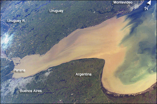 |
| Rio de la Plata is the muddy estuary of the Parana and Uruguay Rivers, and forms part of the border between Argentina and Uruguay. The rich estuary supports both capital cities of Buenos Aires and Montevideo. The Parana is South America's second longest river, and drains much of the southeastern part of the continent. The extensive delta of the Parana nearly reaches across the mouth of the Uruguay River. The rivers' fertile soils support extensive agriculture, including livestock, in the region surrounding the cities. This image provides a snapshot of the complicated mixing in the Rio de la Plata between the fresh river waters and the water of the South Atlantic. The thick sediment plume of the Parana and Uruguay Rivers serves as a marker for the fresher water masses. It can be traced far out into the South Atlantic Ocean. The nutrients in the fresh water plume often feed large plankton blooms offshore. |
| Images: | All Available Images Low-Resolution 77k |
|
| Mission: | ISS008 |
|
| Roll - Frame: | E - 5983 |
|
| Geographical Name: | URUGUAY |
|
| Features: | RIO DE LA PLATA ESTUARY, SED. PLUMES |
|
| Center Lat x Lon: | 35S x 57.5W |
|
| Film Exposure: | N=Normal exposure, U=Under exposed, O=Over exposed, F=out of Focus |
|
| Percentage of Cloud Cover-CLDP: | 10 |
|
| Camera:: | E4 |
|
| Camera Tilt: | LO | LO=Low Oblique, HO=High Oblique, NV=Near Vertical |
| Camera Focal Length: | 80 |
|
| Nadir to Photo Center Direction: | The direction from the nadir to the center point, N=North, S=South, E=East, W=West |
|
| Stereo?: | Y=Yes there is an adjacent picture of the same area, N=No there isn't |
|
| Orbit Number: | |
|
| Date: | 20031114 | YYYYMMDD |
| Time: | 13____ | GMT HHMMSS |
| Nadir Lat: | N |
Latitude of suborbital point of spacecraft |
| Nadir Lon: | E |
Longitude of suborbital point of spacecraft |
| Sun Azimuth: | Clockwise angle in degrees from north to the sun measured at the nadir point |
|
| Space Craft Altitude: | nautical miles |
|
| Sun Elevation: | Angle in degrees between the horizon and the sun, measured at the nadir point |
|
| Land Views: | |
|
| Water Views: | DELTA, ESTUARY, RIVER, SEDIMENT |
|
| Atmosphere Views: | PLUME |
|
| Man Made Views: | AGRICULTURE |
|
| City Views: | |
|
Photo is not associated with any sequences | ||
| NASA Home Page |
JSC Home Page |
JSC Digital Image Collection |
Earth Science & Remote Sensing |
|
This service is provided by the International Space Station program and the JSC Earth Science & Remote Sensing Unit, ARES Division, Exploration Integration Science Directorate.

|