Geographic Region: ARGENTINA
Feature: VIEDMA GLACIER, MORAINES, LAKES
|
Geographic Region: ARGENTINA Feature: VIEDMA GLACIER, MORAINES, LAKES |
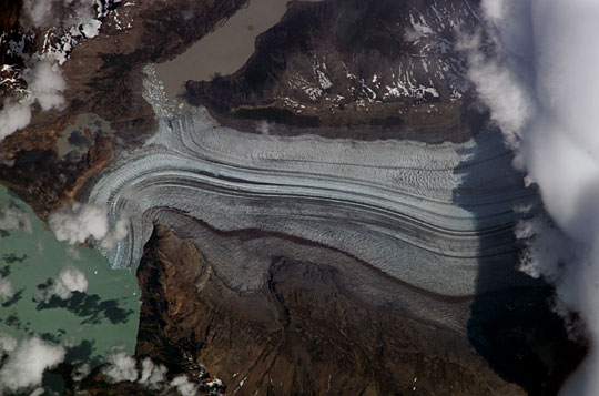 |
| Viedma Glacier, Southern Argentina: This detailed view was taken with an 800 mm lens from the International Space Station on 10 January, 2004. The image shows the lower end of the Viedma Glacier that flows into Lake Viedma, one of three major glacially formed lakes on the Patagonian side of the southern Andean ice sheet, at 50 degrees South. The image reveals the slender dark lines of rock material (moraine) which is carried in the slowly flowing ice. Lighter lines at right angles are patterns of crevasses. The glacier diverges into two lakes where calved icebergs can be seen floating in the lakes. The glacier here is about 1.8 km wide. The thickest moraine parallels the north side of the valley. This moraine separates lighter-colored ice to the south (in the main part of the glacier) from darker ice along the northern margin (between arrows). The ice is darker due to greater proportions of rock material mixed with it. Ice on the northern margin flows into embayments in the valley wall (top center and top left), resulting in a greater flow distance and hence more time for the ice to be impregnated with rocky material from the valley floor and walls. |
| Images: | All Available Images Low-Resolution 46k |
|
| Mission: | ISS008 |
|
| Roll - Frame: | E - 12390 |
|
| Geographical Name: | ARGENTINA |
|
| Features: | VIEDMA GLACIER, MORAINES, LAKES |
|
| Center Lat x Lon: | 49.5S x 73W |
|
| Film Exposure: | N=Normal exposure, U=Under exposed, O=Over exposed, F=out of Focus |
|
| Percentage of Cloud Cover-CLDP: | 10 |
|
| Camera:: | E4 |
|
| Camera Tilt: | HO | LO=Low Oblique, HO=High Oblique, NV=Near Vertical |
| Camera Focal Length: | 800 |
|
| Nadir to Photo Center Direction: | E | The direction from the nadir to the center point, N=North, S=South, E=East, W=West |
| Stereo?: | Y=Yes there is an adjacent picture of the same area, N=No there isn't |
|
| Orbit Number: | 1346 |
|
| Date: | 20040110 | YYYYMMDD |
| Time: | 184330 | GMT HHMMSS |
| Nadir Lat: | 51.4S |
Latitude of suborbital point of spacecraft |
| Nadir Lon: | 77.7W |
Longitude of suborbital point of spacecraft |
| Sun Azimuth: | 322 | Clockwise angle in degrees from north to the sun measured at the nadir point |
| Space Craft Altitude: | 205 | nautical miles |
| Sun Elevation: | 56 | Angle in degrees between the horizon and the sun, measured at the nadir point |
| Land Views: | GLACIER, VALLEY |
|
| Water Views: | ICE, LAKE |
|
| Atmosphere Views: | |
|
| Man Made Views: | |
|
| City Views: | |
|
Photo is not associated with any sequences | ||
| NASA Home Page |
JSC Home Page |
JSC Digital Image Collection |
Earth Science & Remote Sensing |
|
This service is provided by the International Space Station program and the JSC Earth Science & Remote Sensing Unit, ARES Division, Exploration Integration Science Directorate.

|