Geographic Region: ZIMBABWE
Feature: ZAMBEZI RIVER, VICTORIA FALLS
|
Geographic Region: ZIMBABWE Feature: ZAMBEZI RIVER, VICTORIA FALLS |
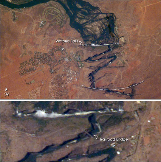 |
| Victoria Falls, Zambezi River: Victoria Falls is one of the most famous tourist sites in subsaharan Africa. Details of the Falls are visible in this image taken with the 800 mm lens by Astronaut Edward Lu from the Space Station on September 4, 2003. A major river in south-central Africa, the Zambezi River flows from western Zambia to the Indian Ocean in Mozambique. In the sector imaged here, it flows southeast (top left to bottom right) in a wide bed before plunging suddenly 130 meters over the Victoria Falls into a narrow gorge. The falls and their famous spray clouds are 1700 m long, the longest sheet of falling water in the world. The falls appear as a ragged white line. The small town of Victoria Falls in Zimbabwe appears just west (left) of the falls, with smaller tourist facilities on the east bank in Zambia. The international railroad bridge over the second gorge (between Zimbabwe and Zambia) can be seen in the detailed view on the bottom (arrow). The positions of the falls are controlled by linear fault lines in the underlying basalt rocks. The falls have moved upstream (bottom to top) by intense river erosion, elongating the zig-zag gorge in the process. Prior positions of the strongly linear falls can be detected. The earliest on this cropped view may have been the longest (dashed line). The zig-zags represent subsequent positions, all with the characteristic water-worn lip on the upstream side. The falls will continue to erode northward. |
| Images: | All Available Images Low-Resolution 73k |
|
| Mission: | ISS007 |
|
| Roll - Frame: | E - 14361 |
|
| Geographical Name: | ZIMBABWE |
|
| Features: | ZAMBEZI RIVER, VICTORIA FALLS |
|
| Center Lat x Lon: | 18S x 26.0E |
|
| Film Exposure: | N=Normal exposure, U=Under exposed, O=Over exposed, F=out of Focus |
|
| Percentage of Cloud Cover-CLDP: | 10 |
|
| Camera:: | E4 |
|
| Camera Tilt: | 16 | LO=Low Oblique, HO=High Oblique, NV=Near Vertical |
| Camera Focal Length: | 800 |
|
| Nadir to Photo Center Direction: | SW | The direction from the nadir to the center point, N=North, S=South, E=East, W=West |
| Stereo?: | Y=Yes there is an adjacent picture of the same area, N=No there isn't |
|
| Orbit Number: | 3338 |
|
| Date: | 20030904 | YYYYMMDD |
| Time: | 110147 | GMT HHMMSS |
| Nadir Lat: | 17.2S |
Latitude of suborbital point of spacecraft |
| Nadir Lon: | 26.6E |
Longitude of suborbital point of spacecraft |
| Sun Azimuth: | 333 | Clockwise angle in degrees from north to the sun measured at the nadir point |
| Space Craft Altitude: | 205 | nautical miles |
| Sun Elevation: | 63 | Angle in degrees between the horizon and the sun, measured at the nadir point |
| Land Views: | EROSION, FAULT |
|
| Water Views: | RIVER |
|
| Atmosphere Views: | |
|
| Man Made Views: | BRIDGE |
|
| City Views: | VICTORIA |
|
Photo is not associated with any sequences | ||
| NASA Home Page |
JSC Home Page |
JSC Digital Image Collection |
Earth Science & Remote Sensing |
|
This service is provided by the International Space Station program and the JSC Earth Science & Remote Sensing Unit, ARES Division, Exploration Integration Science Directorate.

|