
Geographic Region: USA-WASHINGTON
Feature: FOREST FIRE SMOKE, ROCKY MTS.
|
Geographic Region: USA-WASHINGTON Feature: FOREST FIRE SMOKE, ROCKY MTS. |
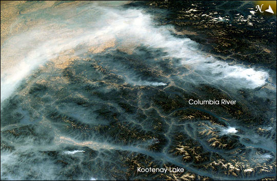 |
| Fires in British Columbia: The 2003 fire season was another very active one for western North America, especially in the Canadian province of British Columbia where some 620,000 acres of forest were consumed in almost 2,500 fires. Here the Rocky Mountains have both lofty, snow-capped peaks and long, narrow valleys that create special conditions and problems with air quality from these smoky fires. This image taken by the crew of the International Space Station on August 20, 2003, illustrates how smoke has become trapped in valleys. Normally air temperature decreases with altitude; in other words, the higher up you are, the colder it is. Warmer, more buoyant air near the surface of the Earth usually rises into the atmosphere, carrying away air pollutants such as smoke. However, sometimes the "higher equals colder" relationship breaks down, for example, here in the northern Rockies, where light winds and cold air drainage from the higher elevations have created "temperature inversions," making the air in the valley colder and denser than the air at the mountain peaks. The cold dense air does not rise, but intsead stays trapped--along with the smoke--in the valleys. Note how the snowy peaks of the mountains are relatively smoke-free while the long, north-south valleys of Kootenay Lake and Columbia River are filled with trapped aerosols from the plumes of the large fires situated to the southwest. Meanwhile shifting winds have now swept the bulk of the plumes southeastward over the Columbia River Basin of Washington. |
| Images: | All Available Images Low-Resolution 62k |
|
| Mission: | ISS007 |
|
| Roll - Frame: | E - 13281 |
|
| Geographical Name: | USA-WASHINGTON |
|
| Features: | FOREST FIRE SMOKE, ROCKY MTS. |
|
| Center Lat x Lon: | 49.0N x 117.5W |
|
| Film Exposure: | N=Normal exposure, U=Under exposed, O=Over exposed, F=out of Focus |
|
| Percentage of Cloud Cover-CLDP: | 50 |
|
| Camera:: | E4 |
|
| Camera Tilt: | HO | LO=Low Oblique, HO=High Oblique, NV=Near Vertical |
| Camera Focal Length: | 50 |
|
| Nadir to Photo Center Direction: | W | The direction from the nadir to the center point, N=North, S=South, E=East, W=West |
| Stereo?: | Y=Yes there is an adjacent picture of the same area, N=No there isn't |
|
| Orbit Number: | 3109 |
|
| Date: | 20030820 | YYYYMMDD |
| Time: | 185120 | GMT HHMMSS |
| Nadir Lat: | 51.7N |
Latitude of suborbital point of spacecraft |
| Nadir Lon: | 110.2W |
Longitude of suborbital point of spacecraft |
| Sun Azimuth: | 167 | Clockwise angle in degrees from north to the sun measured at the nadir point |
| Space Craft Altitude: | 202 | nautical miles |
| Sun Elevation: | 50 | Angle in degrees between the horizon and the sun, measured at the nadir point |
| Land Views: | BASIN, FOREST, MOUNTAIN, VALLEY |
|
| Water Views: | LAKE, RIVER |
|
| Atmosphere Views: | SMOKE |
|
| Man Made Views: | |
|
| City Views: | COLUMBIA |
|
Photo is not associated with any sequences | ||
| NASA Home Page |
JSC Home Page |
JSC Digital Image Collection |
Earth Science & Remote Sensing |
|
This service is provided by the International Space Station program and the JSC Earth Science & Remote Sensing Unit, ARES Division, Exploration Integration Science Directorate.

|