Geographic Region: BRAZIL
Feature: SAO PAULO & SANTOS AT NIGHT
|
Geographic Region: BRAZIL Feature: SAO PAULO & SANTOS AT NIGHT |
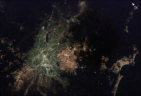 |
| A favorite activity of astronauts and cosmonauts aboard the International Space Station is looking at the city lights below when the Station crosses the Earth's dark side. The lights outline the densest population centers and coastlines, and suggest cultural patterns. Taking these low-light images using the equipment on board the Station has been challenging to the crew members because of the long exposure times required. Astronaut Don Pettit, who leaves the station for Earth today (May 3, 2003), has pioneered an approach using a home-made tracking system to track the ground as it moves relative to the Station, allowing him to acquire long-exposure images under low light conditions. Don's ingenious "Barn-Door Tracker" is a camera mount with a rigged with a hand drill to create a motion tracking system. This image shows the sprawling urban footprint of Sao Paulo, Brazil, South America's largest city with roughly 17 million people. The different colors (pink, white, and gray) define different types and generations of streetlights. The port of Santos, on the right side of the photograph, is also well defined by lights. |
| Images: | All Available Images Low-Resolution 61k |
|
| Mission: | ISS006 |
|
| Roll - Frame: | E - 44689 |
|
| Geographical Name: | BRAZIL |
|
| Features: | SAO PAULO & SANTOS AT NIGHT |
|
| Center Lat x Lon: | 23.5S x 46.5W |
|
| Film Exposure: | N=Normal exposure, U=Under exposed, O=Over exposed, F=out of Focus |
|
| Percentage of Cloud Cover-CLDP: | 10 |
|
| Camera:: | E4 |
|
| Camera Tilt: | 21 | LO=Low Oblique, HO=High Oblique, NV=Near Vertical |
| Camera Focal Length: | 85 |
|
| Nadir to Photo Center Direction: | W | The direction from the nadir to the center point, N=North, S=South, E=East, W=West |
| Stereo?: | Y=Yes there is an adjacent picture of the same area, N=No there isn't |
|
| Orbit Number: | 1069 |
|
| Date: | 20030412 | YYYYMMDD |
| Time: | 023134 | GMT HHMMSS |
| Nadir Lat: | 23.9S |
Latitude of suborbital point of spacecraft |
| Nadir Lon: | 45.2W |
Longitude of suborbital point of spacecraft |
| Sun Azimuth: | 207 | Clockwise angle in degrees from north to the sun measured at the nadir point |
| Space Craft Altitude: | 216 | nautical miles |
| Sun Elevation: | -73 | Angle in degrees between the horizon and the sun, measured at the nadir point |
| Land Views: | |
|
| Water Views: | |
|
| Atmosphere Views: | |
|
| Man Made Views: | PORT |
|
| City Views: | SANTOS, SAO PAULO |
|
Photo is not associated with any sequences | ||
| NASA Home Page |
JSC Home Page |
JSC Digital Image Collection |
Earth Science & Remote Sensing |
|
This service is provided by the International Space Station program and the JSC Earth Science & Remote Sensing Unit, ARES Division, Exploration Integration Science Directorate.

|