Geographic Region: RUSSIAN FEDERATION
Feature: MOUNT KAZBEK, GLACIERS
|
Geographic Region: RUSSIAN FEDERATION Feature: MOUNT KAZBEK, GLACIERS |
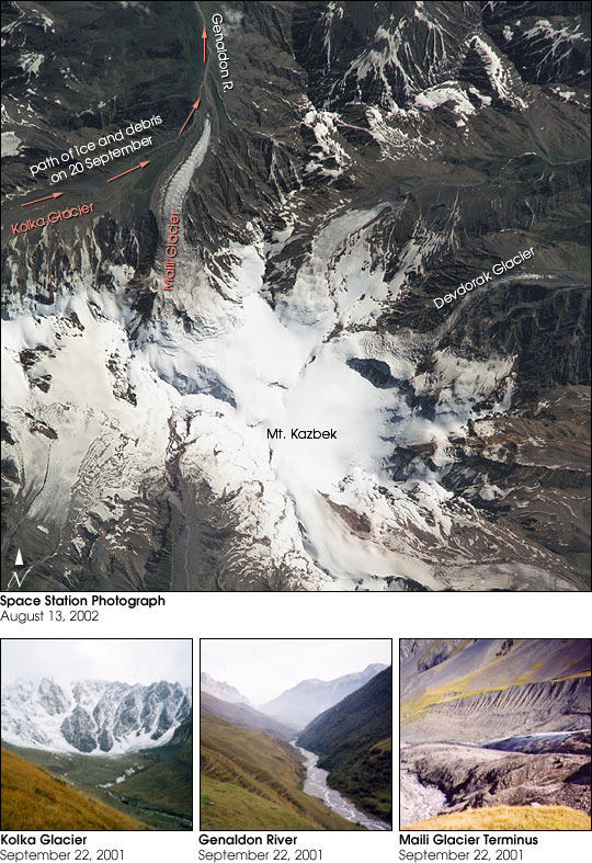 |
| This photograph of Mt. Kazbek was taken from the International Space Station on August 13, 2002. The astronauts and cosmonauts took the photograph at the request of the Russian URAGAN project, which is studying changes in the world's glaciers in response to global climate change. Although scientists have predicted the possibility of large glacial collapses as the climate warms, no one predicted that tragedy would strike the mountain village of Karmadon, a little more than a month later. On September 20 a collapse of a hanging glacier from the slope of Mt Dzhimarai-Khokh onto the Kolka glacier triggered an avalanche of ice and debris that went over the Maili Glacier terminus then slid over 15 miles. It buried small villages in the Russian Republic of North Ossetia, killing dozens of people. Where the ice stopped, the glacial debris flow dammed rivers further below. Several lakes formed and one of them flooded a village. The lakes are now threatening to burst and form debris flows. This photograph shows the lower part of the Kolka Glacier terminus, on to which the glacier from Mt Dzhimarai-Khokh collapsed--the mountain itself is further to the west. However, the Maili Glacier and its terminus, as well as the upper part of the Genaldon River valley that was filled by the debris slide is very clear in the photo. In this very detailed view, Karmadon is much further to the North. Exactly a hundred years ago, in 1902, the same kind of catastrophe happened in this valley, killing 32 people. In 1969 Kolka Glacier surged, but there were no casualties and the villages were not affected. The 1969 surge was studied by a special expedition, however after the glacier stabilized, research in the area stopped. It was concluded that the 1902 catastrophe was also a result of a glacier surge. The latest data on the 2002 catastrophe raise doubts in this conclusion--it is possible that the 1902 event resulted from a similar cascade of collapses. Russian scientists Olga Tutubalina, Dmitry Petrakov, Sergei Chernomorets (Moscow State University) and Lev Dessinov (Russian Academy of Sciences) have been cooperating with the NASA Crew Earth Observations project to help interpret detailed glacier imagery captured from the International Space Station. International Space Station crewmembers are surveying glaciers around the world using their low orbit and high-magnification lenses to get high spatial resolution. |
| Images: | All Available Images Low-Resolution 138k |
|
| Mission: | ISS005 |
|
| Roll - Frame: | E - 9691 |
|
| Geographical Name: | RUSSIAN FEDERATION |
|
| Features: | MOUNT KAZBEK, GLACIERS |
|
| Center Lat x Lon: | 42.5N x 44.5E |
|
| Film Exposure: | N=Normal exposure, U=Under exposed, O=Over exposed, F=out of Focus |
|
| Percentage of Cloud Cover-CLDP: | 10 |
|
| Camera:: | E4 |
|
| Camera Tilt: | 33 | LO=Low Oblique, HO=High Oblique, NV=Near Vertical |
| Camera Focal Length: | 800 |
|
| Nadir to Photo Center Direction: | SW | The direction from the nadir to the center point, N=North, S=South, E=East, W=West |
| Stereo?: | Y=Yes there is an adjacent picture of the same area, N=No there isn't |
|
| Orbit Number: | 1300 |
|
| Date: | 20020813 | YYYYMMDD |
| Time: | 110738 | GMT HHMMSS |
| Nadir Lat: | 44.0N |
Latitude of suborbital point of spacecraft |
| Nadir Lon: | 46.2E |
Longitude of suborbital point of spacecraft |
| Sun Azimuth: | 233 | Clockwise angle in degrees from north to the sun measured at the nadir point |
| Space Craft Altitude: | 208 | nautical miles |
| Sun Elevation: | 50 | Angle in degrees between the horizon and the sun, measured at the nadir point |
| Land Views: | GLACIER, MOUNTAIN, VALLEY |
|
| Water Views: | ICE, RIVER |
|
| Atmosphere Views: | |
|
| Man Made Views: | |
|
| City Views: | |
|
Photo is not associated with any sequences | ||
| NASA Home Page |
JSC Home Page |
JSC Digital Image Collection |
Earth Science & Remote Sensing |
|
This service is provided by the International Space Station program and the JSC Earth Science & Remote Sensing Unit, ARES Division, Exploration Integration Science Directorate.

|