Geographic Region: JAPAN
Feature: HAKODATE CITY
|
Geographic Region: JAPAN Feature: HAKODATE CITY |
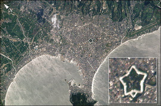 |
| This photograph taken from the window of the International Space Station on August 22, 2002 shows Hakodate City, Japan (population 288,491). Hakodate City is a seaport located on two bays in the Oshima Peninsula near the south end of the major Japanese island of Hokkaido. This image nicely illustrates how sunglint reflecting off the ocean reveals internal waves impinging on the coast. Also, from space, Hakodate is quite distinguished from other cities of it size, featuring a large five-pointed star near it center. The star known as "Goryokaku" is actually the first Western-style fort built in Japan from 1857-64. Today the historic fort is a 251,400 square meter (62 acre) park (note the green center), well known for its majestic cherry blossoms. It is also now a major tourist attraction. In the hundred feet wide outer moat (higlighted by sunglint) large, colorful Japanese Carp and boat rentals are popular attractions. |
| Images: | All Available Images Low-Resolution 72k |
|
| Mission: | ISS005 |
|
| Roll - Frame: | E - 10643 |
|
| Geographical Name: | JAPAN |
|
| Features: | HAKODATE CITY |
|
| Center Lat x Lon: | 42.0N x 140.5E |
|
| Film Exposure: | N=Normal exposure, U=Under exposed, O=Over exposed, F=out of Focus |
|
| Percentage of Cloud Cover-CLDP: | 10 |
|
| Camera:: | E4 |
|
| Camera Tilt: | 29 | LO=Low Oblique, HO=High Oblique, NV=Near Vertical |
| Camera Focal Length: | 800 |
|
| Nadir to Photo Center Direction: | SE | The direction from the nadir to the center point, N=North, S=South, E=East, W=West |
| Stereo?: | Y=Yes there is an adjacent picture of the same area, N=No there isn't |
|
| Orbit Number: | 1434 |
|
| Date: | 20020822 | YYYYMMDD |
| Time: | 012527 | GMT HHMMSS |
| Nadir Lat: | 43.6N |
Latitude of suborbital point of spacecraft |
| Nadir Lon: | 139.4E |
Longitude of suborbital point of spacecraft |
| Sun Azimuth: | 145 | Clockwise angle in degrees from north to the sun measured at the nadir point |
| Space Craft Altitude: | 211 | nautical miles |
| Sun Elevation: | 54 | Angle in degrees between the horizon and the sun, measured at the nadir point |
| Land Views: | COAST, ISLAND, PENINSULA |
|
| Water Views: | OCEAN, SUNGLINT |
|
| Atmosphere Views: | |
|
| Man Made Views: | |
|
| City Views: | HAKODATE |
|
Photo is not associated with any sequences | ||
| NASA Home Page |
JSC Home Page |
JSC Digital Image Collection |
Earth Science & Remote Sensing |
|
This service is provided by the International Space Station program and the JSC Earth Science & Remote Sensing Unit, ARES Division, Exploration Integration Science Directorate.

|