ISS040-E-12110
| NASA Photo ID | ISS040-E-12110 |
| Focal Length | 80mm |
| Date taken | 2014.06.15 |
| Time taken | 18:03:48 GMT |
Resolutions offered for this image:
1000 x 665 pixels 540 x 359 pixels 1440 x 960 pixels 720 x 480 pixels 4256 x 2832 pixels 640 x 426 pixels
1000 x 665 pixels 540 x 359 pixels 1440 x 960 pixels 720 x 480 pixels 4256 x 2832 pixels 640 x 426 pixels


Spacecraft nadir point: 51.6° N, 28.6° E
Photo center point: 56.5° N, 16.5° E
Photo center point by machine learning:
Photo center point: 56.5° N, 16.5° E
Photo center point by machine learning:
Nadir to Photo Center: West
Spacecraft Altitude: 219 nautical miles (406km)
Country or Geographic Name: | SWEDEN |
Features: | PAN--BALTIC SEA, GLINT, POLAND, S SWEDEN, DENMARK |
| Features Found Using Machine Learning: | PAN- |
Cloud Cover Percentage: | 50 (26-50)% |
Sun Elevation Angle: | 2° |
Sun Azimuth: | 307° |
Camera: | Nikon D3S Electronic Still Camera |
Focal Length: | 80mm |
Camera Tilt: | High Oblique |
Format: | 4256E: 4256 x 2832 pixel CMOS sensor, 36.0mm x 23.9mm, total pixels: 12.87 million, Nikon FX format |
Film Exposure: | |
| Additional Information | |
| Width | Height | Annotated | Cropped | Purpose | Links |
|---|---|---|---|---|---|
| 1000 pixels | 665 pixels | No | No | Earth From Space collection | Download Image |
| 540 pixels | 359 pixels | Yes | No | Earth From Space collection | Download Image |
| 1440 pixels | 960 pixels | No | No | NASA's Earth Observatory web site | Download Image |
| 720 pixels | 480 pixels | Yes | No | NASA's Earth Observatory web site | Download Image |
| 4256 pixels | 2832 pixels | No | No | Download Image | |
| 640 pixels | 426 pixels | No | No | Download Image |
Download Packaged File
Download a Google Earth KML for this Image
View photo footprint information
Download a GeoTIFF for this photo
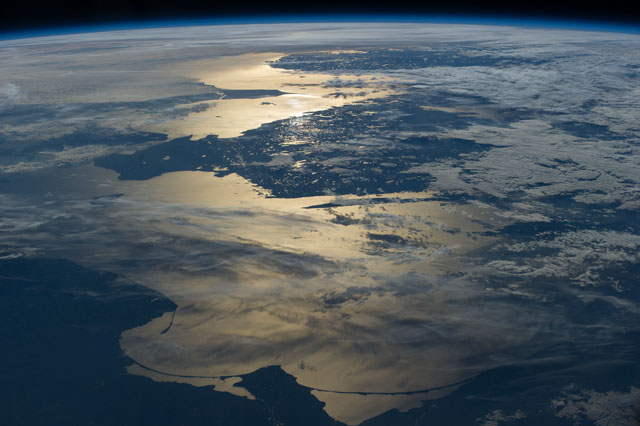
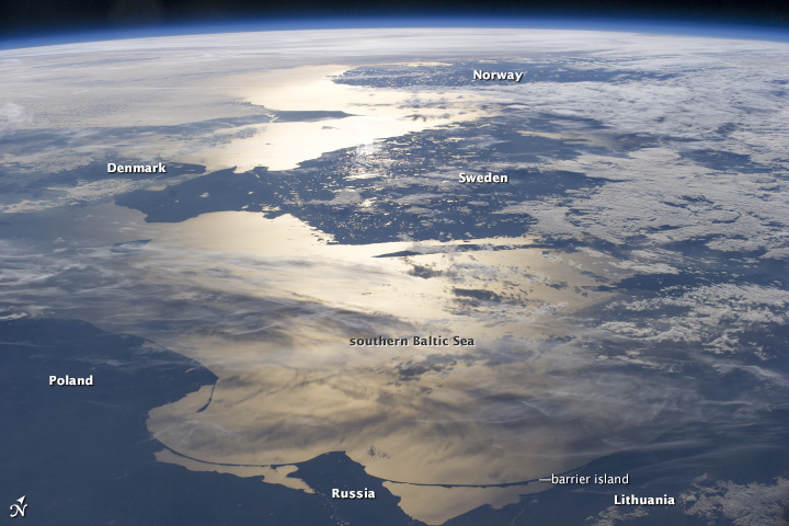
Image Caption: Coastlines of the Southern Baltic Sea
The crew of the International Space Station (ISS) took this panorama looking aft (back along the orbital path) of the spacecraft as the sun was setting over the North Sea. Seen from the ISS, the sun's reflection point moves quickly across the landscape, momentarily lighting up water bodies. In this fleeting view the coast of southern Norway is outlined near the horizon. The strongest reflection of the sun highlights the narrow sea passage known as the Skagerrak--revealing the thin tip of Denmark. Numerous small lakes in southern Sweden appear image center, and scattered clouds cast complex shadows on the southern Baltic Sea. The sweeping curves of the sand spit on the Polish coast, and the long barrier islands on the Russian coast appear in the foreground at the edge of the sun's reflection disc.
The crew of the International Space Station (ISS) took this panorama looking aft (back along the orbital path) of the spacecraft as the sun was setting over the North Sea. Seen from the ISS, the sun's reflection point moves quickly across the landscape, momentarily lighting up water bodies. In this fleeting view the coast of southern Norway is outlined near the horizon. The strongest reflection of the sun highlights the narrow sea passage known as the Skagerrak--revealing the thin tip of Denmark. Numerous small lakes in southern Sweden appear image center, and scattered clouds cast complex shadows on the southern Baltic Sea. The sweeping curves of the sand spit on the Polish coast, and the long barrier islands on the Russian coast appear in the foreground at the edge of the sun's reflection disc.
