AS17-148-22727
| NASA Photo ID | AS17-148-22727 |
| Focal Length | mm |
| Date taken | 1972.12.__ |
| Time taken | GMT |
Resolutions offered for this image:
540 x 540 pixels 2330 x 2527 pixels 4400 x 4600 pixels 492 x 515 pixels 1536 x 1024 pixels 1536 x 1024 pixels 2330 x 2527 pixels
540 x 540 pixels 2330 x 2527 pixels 4400 x 4600 pixels 492 x 515 pixels 1536 x 1024 pixels 1536 x 1024 pixels 2330 x 2527 pixels


Cloud masks available for this image:
Spacecraft nadir point:
Photo center point:
Photo center point by machine learning:
Photo center point:
Photo center point by machine learning:
Nadir to Photo Center:
Spacecraft Altitude: nautical miles (0km)
Country or Geographic Name: | AFRICA |
Features: | AFRICAN CONTINENT, BLUE MARBLE |
| Features Found Using Machine Learning: | |
Cloud Cover Percentage: | 50 (26-50)% |
Sun Elevation Angle: | ° |
Sun Azimuth: | ° |
Camera: | |
Focal Length: | mm |
Camera Tilt: | |
Format: | |
Film Exposure: | |
| Additional Information | |
| Width | Height | Annotated | Cropped | Purpose | Links |
|---|---|---|---|---|---|
| 540 pixels | 540 pixels | No | Earth From Space collection | Download Image | |
| 2330 pixels | 2527 pixels | NASA's Earth Observatory web site | Download Image | ||
| 4400 pixels | 4600 pixels | No | No | Download Image | |
| 492 pixels | 515 pixels | No | No | Download Image | |
| 1536 pixels | 1024 pixels | No | Yes | Download Image | |
| 1536 pixels | 1024 pixels | No | Yes | Download Image | |
| 2330 pixels | 2527 pixels | No | No | Download Image |
Download Packaged File
Download a Google Earth KML for this Image
View photo footprint information
Download a GeoTIFF for this photo
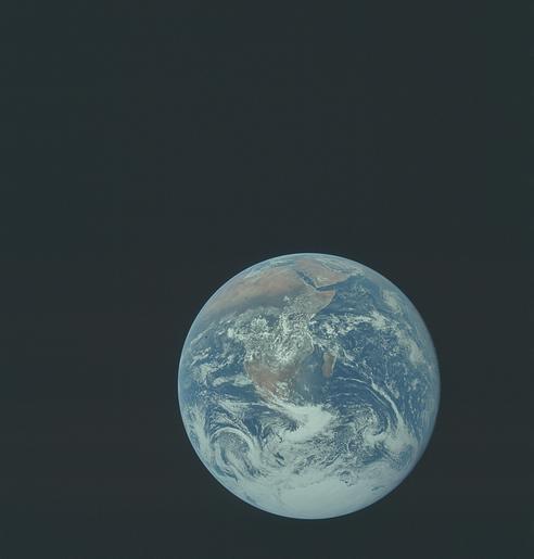
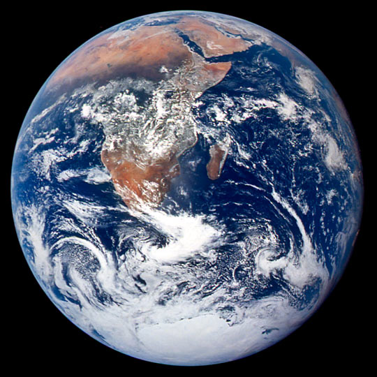
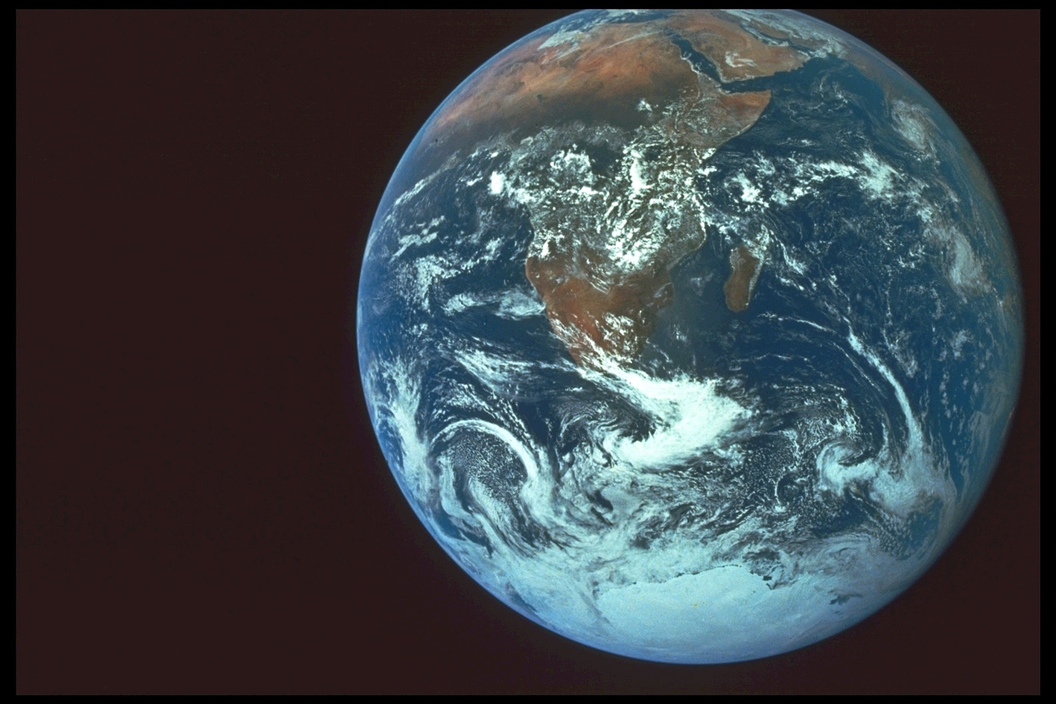
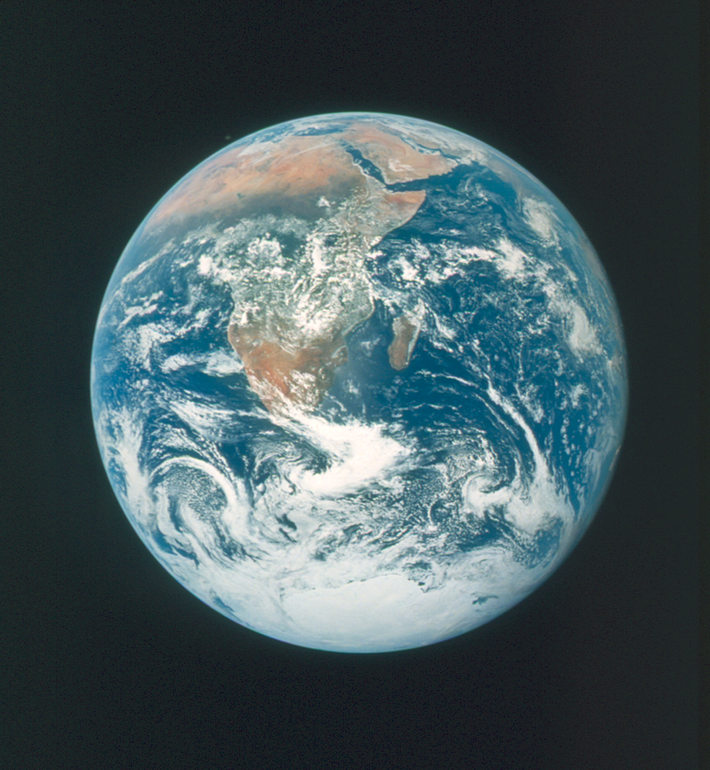
Image Caption: This classic photograph of the Earth was taken on December 7, 1972. The original caption is reprinted below:
View of the Earth as seen by the Apollo 17 crew traveling toward the moon. This translunar coast photograph extends from the Mediterranean Sea area to the Antarctica south polar ice cap. This is the first time the Apollo trajectory made it possible to photograph the south polar ice cap. Note the heavy cloud cover in the Southern Hemisphere. Almost the entire coastline of Africa is clearly visible. The Arabian Peninsula can be seen at the northeastern edge of Africa. The large island off the east coast of Africa is the Republic of Madagascar. The Asian mainland is on the horizon toward the northeast.
View of the Earth as seen by the Apollo 17 crew traveling toward the moon. This translunar coast photograph extends from the Mediterranean Sea area to the Antarctica south polar ice cap. This is the first time the Apollo trajectory made it possible to photograph the south polar ice cap. Note the heavy cloud cover in the Southern Hemisphere. Almost the entire coastline of Africa is clearly visible. The Arabian Peninsula can be seen at the northeastern edge of Africa. The large island off the east coast of Africa is the Republic of Madagascar. The Asian mainland is on the horizon toward the northeast.
