STS61C-33-84
| NASA Photo ID | STS61C-33-84 |
| Focal Length | 250mm |
| Date taken | 1986.01.__ |
| Time taken | GMT |
Resolutions offered for this image:
5312 x 5312 pixels 640 x 640 pixels 5700 x 5900 pixels 500 x 518 pixels 640 x 480 pixels
5312 x 5312 pixels 640 x 640 pixels 5700 x 5900 pixels 500 x 518 pixels 640 x 480 pixels


Cloud masks available for this image:
Spacecraft nadir point:
Photo center point: 3.0° S, 60.0° W
Photo center point by machine learning:
Photo center point: 3.0° S, 60.0° W
Photo center point by machine learning:
Nadir to Photo Center:
Spacecraft Altitude: nautical miles (0km)
Country or Geographic Name: | BRAZIL |
Features: | MANAUS, AMAZON, R. R. NEGRO |
| Features Found Using Machine Learning: | |
Cloud Cover Percentage: | 30 (26-50)% |
Sun Elevation Angle: | ° |
Sun Azimuth: | ° |
Camera: | Hasselblad |
Focal Length: | 250mm |
Camera Tilt: | Low Oblique |
Format: | 5017: Kodak, natural color positive, Ektachrome, X Professional, ASA 64, standard base |
Film Exposure: | Normal |
| Additional Information | |
| Width | Height | Annotated | Cropped | Purpose | Links |
|---|---|---|---|---|---|
| 5312 pixels | 5312 pixels | No | No | Earth From Space collection | Download Image |
| 640 pixels | 640 pixels | No | No | Earth From Space collection | Download Image |
| 5700 pixels | 5900 pixels | No | No | Download Image | |
| 500 pixels | 518 pixels | No | No | Download Image | |
| 640 pixels | 480 pixels | No | No | Download Image |
Download Packaged File
Download a Google Earth KML for this Image
View photo footprint information
Download a GeoTIFF for this photo
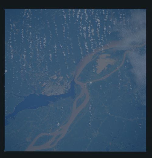
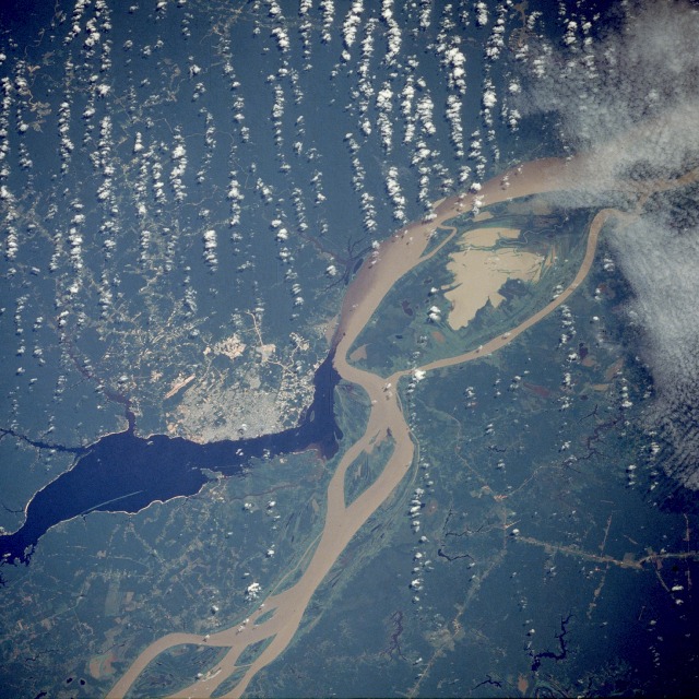
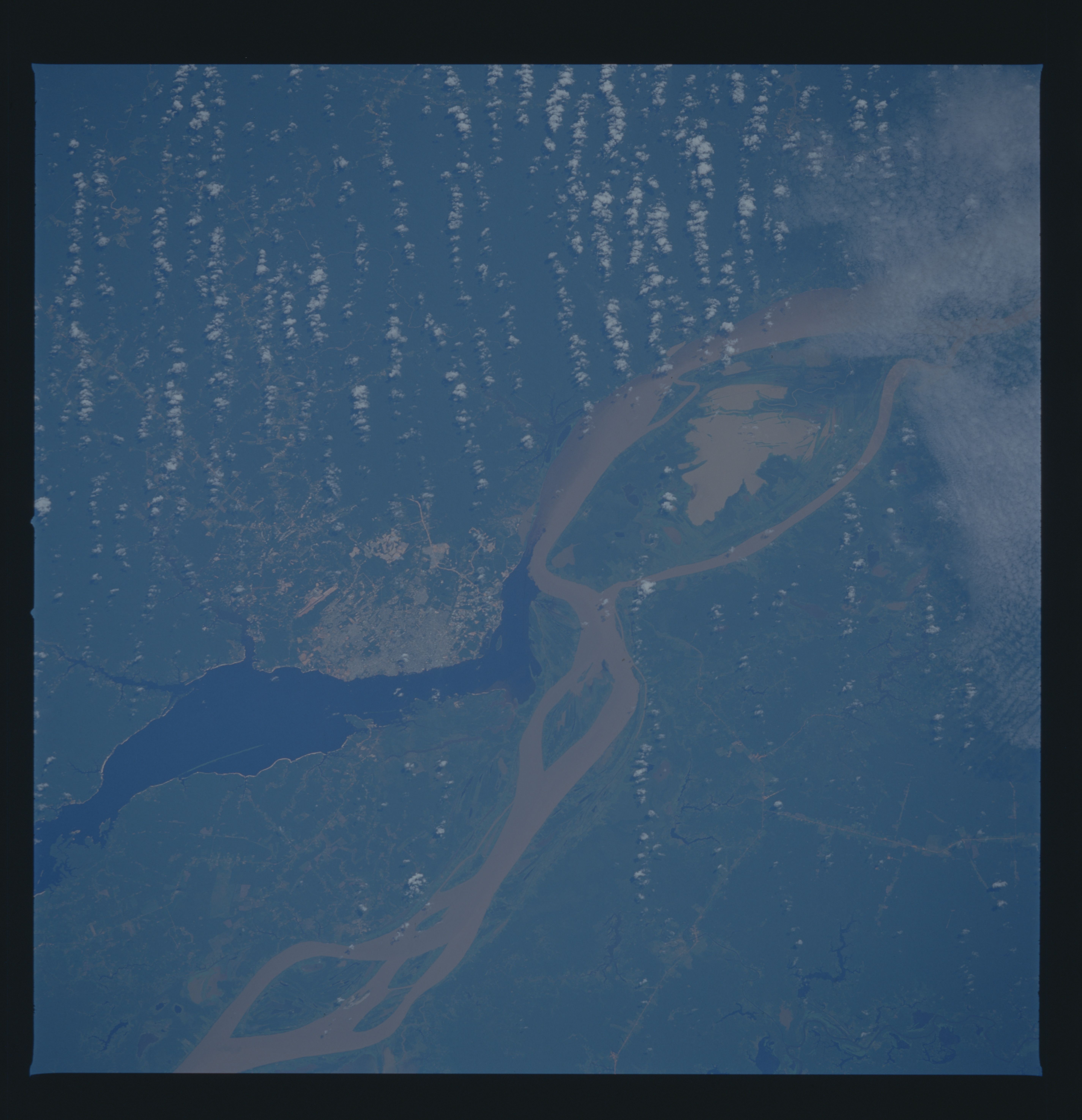
Image Caption: STS61C-33-84 Manaus, Amazonas, Brazil January 1986
Two rivers and an urban area dominate this photograph. The largest city in the Amazon Basin, Manaus (with a 1994 population of 1.7 million), is located at the confluence of the Rio Negro (dark blue) and the Amazon River (lighter because of its high sediment content). The combined river flows eastward into the Atlantic Ocean. Situated approximately 800 miles (1290 kilometers) from the mouth of the Amazon River but accessible to oceangoing ships, Manaus is an important river port. This port city started to flourish in the late 1800s when the rubber boom was at its peak. Rubber, Brazil nuts, lumber, and assorted fruits are exported. In recent years, renewed interest in general development and the discovery of oil and manganese near Manaus have brought new importance to the city. A number of highways (linear, light-colored features), as well as a large commercial airport north of the city, are visible in the rain forest north and south of Manaus. North-south ground transportation is hindered because no bridges cross the Rio Negro or Amazon River. A large, sediment-laden lake (note irregular shoreline) is located east of Manaus between the main channel of the Amazon River and a smaller channel to the south.
Two rivers and an urban area dominate this photograph. The largest city in the Amazon Basin, Manaus (with a 1994 population of 1.7 million), is located at the confluence of the Rio Negro (dark blue) and the Amazon River (lighter because of its high sediment content). The combined river flows eastward into the Atlantic Ocean. Situated approximately 800 miles (1290 kilometers) from the mouth of the Amazon River but accessible to oceangoing ships, Manaus is an important river port. This port city started to flourish in the late 1800s when the rubber boom was at its peak. Rubber, Brazil nuts, lumber, and assorted fruits are exported. In recent years, renewed interest in general development and the discovery of oil and manganese near Manaus have brought new importance to the city. A number of highways (linear, light-colored features), as well as a large commercial airport north of the city, are visible in the rain forest north and south of Manaus. North-south ground transportation is hindered because no bridges cross the Rio Negro or Amazon River. A large, sediment-laden lake (note irregular shoreline) is located east of Manaus between the main channel of the Amazon River and a smaller channel to the south.
