STS61A-50-10
| NASA Photo ID | STS61A-50-10 |
| Focal Length | 100mm |
| Date taken | 1985.10.31 |
| Time taken | 19:02:27 GMT |


Cloud masks available for this image:
Spacecraft nadir point: 54.2° N, 72.7° W
Photo center point: 51.0° N, 68.5° W
Photo center point by machine learning:
Photo center point: 51.0° N, 68.5° W
Photo center point by machine learning:
Nadir to Photo Center: Southeast
Spacecraft Altitude: 182 nautical miles (337km)
Country or Geographic Name: | CANADA-Q |
Features: | RESERVOIR MANICOUAGAN |
| Features Found Using Machine Learning: | |
Cloud Cover Percentage: | 20 (11-25)% |
Sun Elevation Angle: | 14° |
Sun Azimuth: | 217° |
Camera: | Hasselblad |
Focal Length: | 100mm |
Camera Tilt: | Low Oblique |
Format: | 5017: Kodak, natural color positive, Ektachrome, X Professional, ASA 64, standard base |
Film Exposure: | Normal |
| Additional Information | |
| Width | Height | Annotated | Cropped | Purpose | Links |
|---|---|---|---|---|---|
| 5700 pixels | 5900 pixels | No | No | Download Image | |
| 500 pixels | 518 pixels | No | No | Download Image | |
| 640 pixels | 480 pixels | No | No | Download Image |
Download Packaged File
Download a Google Earth KML for this Image
View photo footprint information
Download a GeoTIFF for this photo
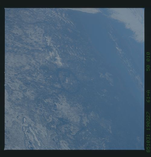
Image Caption: STS61A-050-10 Manicouagan Manicouagan impact crater (51 23'N, 68 42'W)
is one of the best known of the Canadian impact craters. Located in
Quebec, Manicouagan is 100 km in diameter, and has an age of 212 + 2
m.y. North is toward the left. The Saint Lawrence River and the Gaspe
Peninsula can be seen in the upper right. T283C
is one of the best known of the Canadian impact craters. Located in
Quebec, Manicouagan is 100 km in diameter, and has an age of 212 + 2
m.y. North is toward the left. The Saint Lawrence River and the Gaspe
Peninsula can be seen in the upper right. T283C
