STS61A-42-51
| NASA Photo ID | STS61A-42-51 |
| Focal Length | 250mm |
| Date taken | 1985.11.05 |
| Time taken | 15:43:34 GMT |
Resolutions offered for this image:
3919 x 3952 pixels 634 x 639 pixels 5700 x 5900 pixels 500 x 518 pixels 640 x 480 pixels 446 x 432 pixels
3919 x 3952 pixels 634 x 639 pixels 5700 x 5900 pixels 500 x 518 pixels 640 x 480 pixels 446 x 432 pixels


Cloud masks available for this image:
Spacecraft nadir point: 31.7° N, 90.1° W
Photo center point: 29.0° N, 89.0° W
Photo center point by machine learning:
Photo center point: 29.0° N, 89.0° W
Photo center point by machine learning:
Nadir to Photo Center: South
Spacecraft Altitude: 177 nautical miles (328km)
Country or Geographic Name: | USA-LOUISIANA |
Features: | MISSISSIPPI RIVER DELTA |
| Features Found Using Machine Learning: | |
Cloud Cover Percentage: | 0 (no clouds present) |
Sun Elevation Angle: | 34° |
Sun Azimuth: | 144° |
Camera: | Hasselblad |
Focal Length: | 250mm |
Camera Tilt: | 45 degrees |
Format: | 5017: Kodak, natural color positive, Ektachrome, X Professional, ASA 64, standard base |
Film Exposure: | Normal |
| Additional Information | |
| Width | Height | Annotated | Cropped | Purpose | Links |
|---|---|---|---|---|---|
| 3919 pixels | 3952 pixels | No | No | Earth From Space collection | Download Image |
| 634 pixels | 639 pixels | No | No | Earth From Space collection | Download Image |
| 5700 pixels | 5900 pixels | No | No | Download Image | |
| 500 pixels | 518 pixels | No | No | Download Image | |
| 640 pixels | 480 pixels | No | No | Download Image | |
| 446 pixels | 432 pixels | Download Image |
Download Packaged File
Download a Google Earth KML for this Image
View photo footprint information
Download a GeoTIFF for this photo
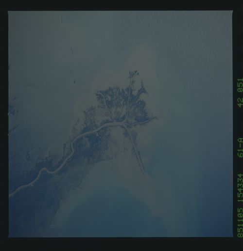
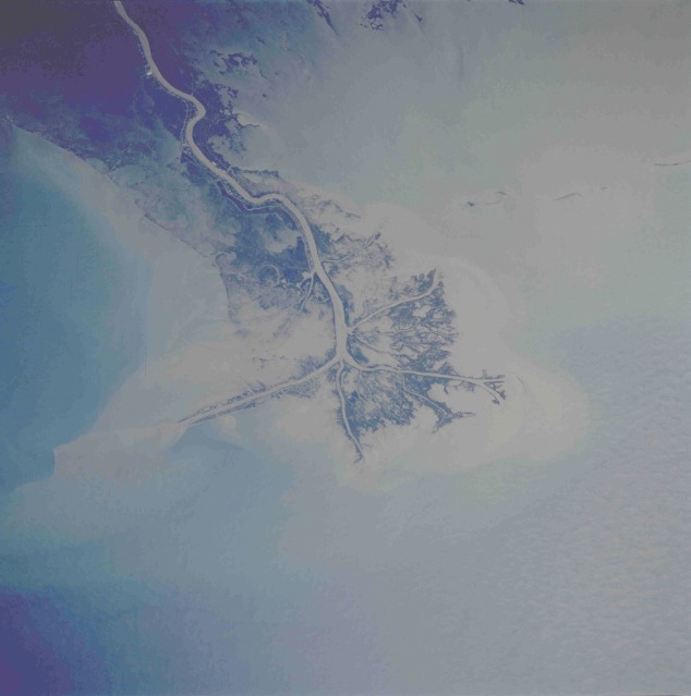
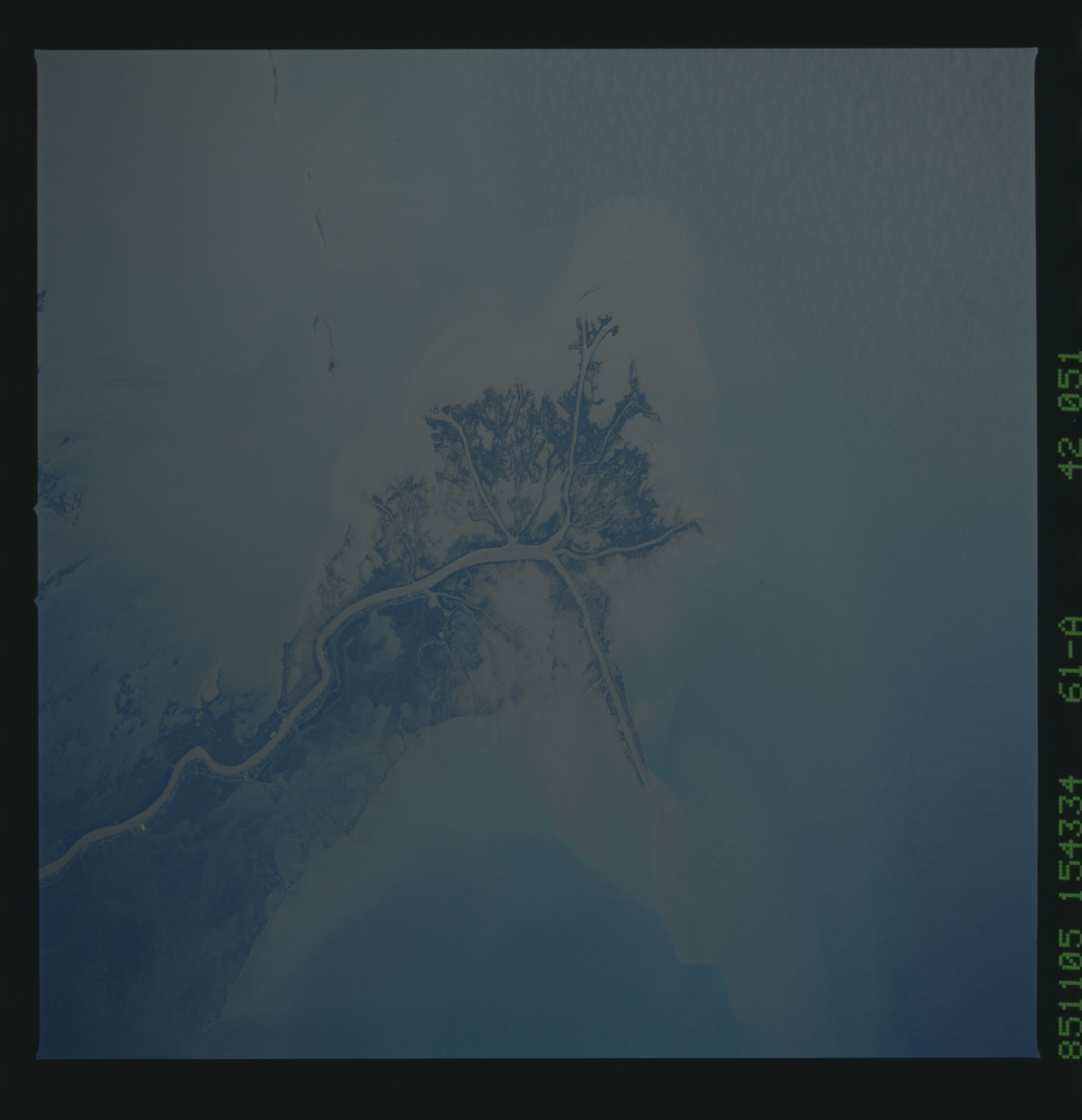
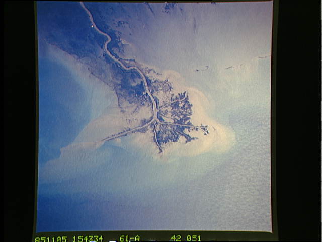
Image Caption: STS61A-42-51 Mississippi River Delta, Louisiana, U.S.A. October 1985
The Mississippi River carries more than 200 million tons (181 million metric tons) of sediment annually past the city of New Orleans and into the Gulf of Mexico to form a fast-growing delta. This low-oblique, south-looking photograph shows the tremendous quantity of silt deposited through the distributory channel system at the southern end of the Mississippi River. This particular deposition pattern, called a "bird's foot" delta, is the only such delta in the world. Constant dredging is required for oceangoing ships to navigate the main channel of the Mississippi River. This photograph shows a dynamic scene of surface winds creating a current flow in the water, which is moving the sediment in a westerly direction. The northeastern section of the delta has been set aside as the Delta National Wildlife Refuge. State Highway 23, which eventually makes its way to New Orleans and beyond, can be seen along the western side of the main channel. (Refer to STS51C-143-27 for a more synoptic view of the delta area and its relationship to the city of New Orleans.)
The Mississippi River carries more than 200 million tons (181 million metric tons) of sediment annually past the city of New Orleans and into the Gulf of Mexico to form a fast-growing delta. This low-oblique, south-looking photograph shows the tremendous quantity of silt deposited through the distributory channel system at the southern end of the Mississippi River. This particular deposition pattern, called a "bird's foot" delta, is the only such delta in the world. Constant dredging is required for oceangoing ships to navigate the main channel of the Mississippi River. This photograph shows a dynamic scene of surface winds creating a current flow in the water, which is moving the sediment in a westerly direction. The northeastern section of the delta has been set aside as the Delta National Wildlife Refuge. State Highway 23, which eventually makes its way to New Orleans and beyond, can be seen along the western side of the main channel. (Refer to STS51C-143-27 for a more synoptic view of the delta area and its relationship to the city of New Orleans.)
