STS61A-201-21
| NASA Photo ID | STS61A-201-21 |
| Focal Length | 250mm |
| Date taken | 1985.__.__ |
| Time taken | GMT |
Resolutions offered for this image:
640 x 480 pixels
640 x 480 pixels
Cloud masks available for this image:
Spacecraft nadir point:
Photo center point: 31.0° N, 30.0° E
Photo center point by machine learning:
Photo center point: 31.0° N, 30.0° E
Photo center point by machine learning:
Nadir to Photo Center:
Spacecraft Altitude: nautical miles (0km)
Country or Geographic Name: | EGYPT |
Features: | NILE R. DELTA, EDDIES |
| Features Found Using Machine Learning: | |
Cloud Cover Percentage: | 5 (1-10)% |
Sun Elevation Angle: | ° |
Sun Azimuth: | ° |
Camera: | Linhof |
Focal Length: | 250mm |
Camera Tilt: | High Oblique |
Format: | 5017: Kodak, natural color positive, Ektachrome, X Professional, ASA 64, standard base |
Film Exposure: | Normal |
| Additional Information | |
| Width | Height | Annotated | Cropped | Purpose | Links |
|---|---|---|---|---|---|
| 640 pixels | 480 pixels | No | No | ISD 1 | Download Image |
Download Packaged File
Download a Google Earth KML for this Image
View photo footprint information
Download a GeoTIFF for this photo
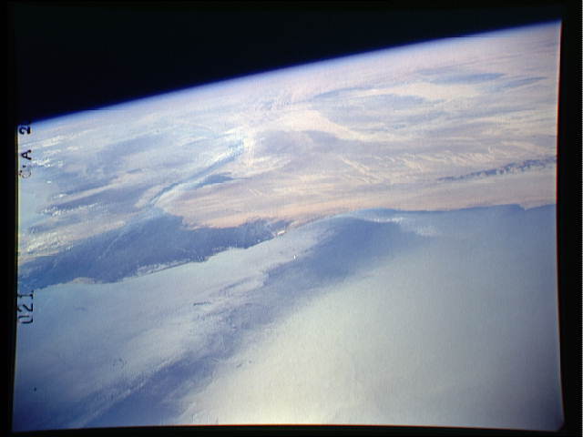
Image Caption: This oblique, south-looking view of the Egyptian coast shows the
heavily vegetated delta of the Nile (left), with the Nile Valley
and Farafra oasis stretching into the great Sahara beyond. The
Aswan Dam hasregularized flood water for irrigation, but reduced
drastically the amount of nutrient flowing into the Mediterrane-
an. This in turn has reduced the size of fish populations and
hurt the Egyptian fishing industry.
The WWII battleground of El Alamein (arrow), where Montgomery's
Eighth Army met Rommel's Afrika Korps, is bounded to the south by
the Qatara depression (1) and to the north by the sea.
Around six million years ago it is believed that the Mediterrane-
an Sea dried up completely, forming an enormous basin well below
sea level in which atmospheric temperatures must have been far
higher than any presently recorded maxima. The Nile River cut a
great canyon in response to this drastic event. The present Nile
Valley floor and delta are thus geologically young features being
related to the present sea level of the Mediterranean.
