STS61A-200-127
| NASA Photo ID | STS61A-200-127 |
| Focal Length | 250mm |
| Date taken | 1985.__.__ |
| Time taken | GMT |

Cloud masks available for this image:
Spacecraft nadir point:
Photo center point: 36.5° N, 110.5° W
Photo center point by machine learning:
Photo center point: 36.5° N, 110.5° W
Photo center point by machine learning:
Nadir to Photo Center:
Spacecraft Altitude: nautical miles (0km)
Country or Geographic Name: | USA-ARIZONA |
Features: | BLACK MESA, COLORADO R. |
| Features Found Using Machine Learning: | |
Cloud Cover Percentage: | 5 (1-10)% |
Sun Elevation Angle: | ° |
Sun Azimuth: | ° |
Camera: | Linhof |
Focal Length: | 250mm |
Camera Tilt: | Low Oblique |
Format: | 5017: Kodak, natural color positive, Ektachrome, X Professional, ASA 64, standard base |
Film Exposure: | Normal |
| Additional Information | |
| Width | Height | Annotated | Cropped | Purpose | Links |
|---|---|---|---|---|---|
| 5152 pixels | 4096 pixels | No | No | Earth From Space collection | Download Image |
| 640 pixels | 508 pixels | No | No | Earth From Space collection | Download Image |
| 640 pixels | 480 pixels | No | No | ISD 1 | Download Image |
Download Packaged File
Download a Google Earth KML for this Image
View photo footprint information
Download a GeoTIFF for this photo
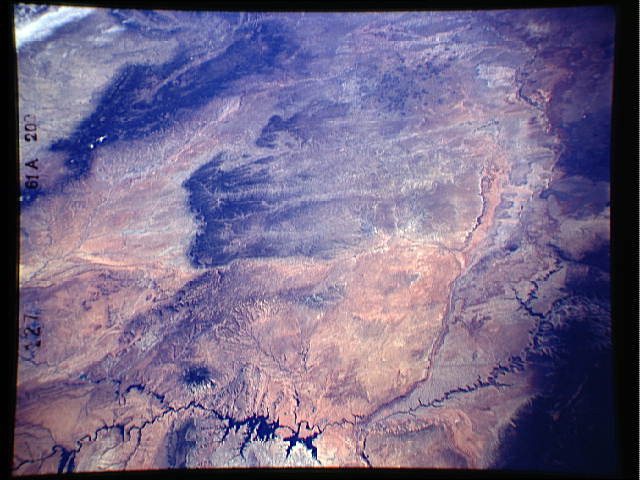
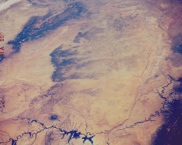
Image Caption: STS61A-200-0127 Colorado Plateau, Arizona, U.S.A. November 1985
A synoptic view of the arid Colorado Plateau is captured in this southeast-looking photograph of northeastern Arizona from the deeply incised Colorado River as it passes through Marble Canyon to the dark Chuska Mountains that straddle the Arizona-New Mexico border. To the north (bottom of the photograph) Lake Powell and the Glen Canyon Dam area are visible. Most of the drainage features in this desert landscape consist of intermittently flowing streams (washes), one of which is the Little Colorado River. Other physical features include Navajo Mountain [a solitary peak 10 346 feet (3153 meters) above sea level], Black Mesa (the elevated plateau near the center of the photograph), Echo Cliffs (the linear feature toward the northwest side of the photograph in the lower right quadrant), and the Painted Desert (upper right corner).
A synoptic view of the arid Colorado Plateau is captured in this southeast-looking photograph of northeastern Arizona from the deeply incised Colorado River as it passes through Marble Canyon to the dark Chuska Mountains that straddle the Arizona-New Mexico border. To the north (bottom of the photograph) Lake Powell and the Glen Canyon Dam area are visible. Most of the drainage features in this desert landscape consist of intermittently flowing streams (washes), one of which is the Little Colorado River. Other physical features include Navajo Mountain [a solitary peak 10 346 feet (3153 meters) above sea level], Black Mesa (the elevated plateau near the center of the photograph), Echo Cliffs (the linear feature toward the northwest side of the photograph in the lower right quadrant), and the Painted Desert (upper right corner).
