STS51I-37-37
| NASA Photo ID | STS51I-37-37 |
| Focal Length | 250mm |
| Date taken | 1985.08.28 |
| Time taken | 18:12:41 GMT |
Resolutions offered for this image:
5276 x 5223 pixels 640 x 633 pixels 5700 x 5900 pixels 500 x 518 pixels 640 x 480 pixels
5276 x 5223 pixels 640 x 633 pixels 5700 x 5900 pixels 500 x 518 pixels 640 x 480 pixels


Cloud masks available for this image:
Spacecraft nadir point: 21.7° S, 51.3° W
Photo center point: 22.5° S, 53.0° W
Photo center point by machine learning:
Photo center point: 22.5° S, 53.0° W
Photo center point by machine learning:
Nadir to Photo Center: West
Spacecraft Altitude: 192 nautical miles (356km)
Country or Geographic Name: | BRAZIL |
Features: | R. PARANA, R. PARANAPANEMA |
| Features Found Using Machine Learning: | |
Cloud Cover Percentage: | 5 (1-10)% |
Sun Elevation Angle: | 38° |
Sun Azimuth: | 303° |
Camera: | Hasselblad |
Focal Length: | 250mm |
Camera Tilt: | 30 degrees |
Format: | 5017: Kodak, natural color positive, Ektachrome, X Professional, ASA 64, standard base |
Film Exposure: | Normal |
| Additional Information | |
| Width | Height | Annotated | Cropped | Purpose | Links |
|---|---|---|---|---|---|
| 5276 pixels | 5223 pixels | No | No | Earth From Space collection | Download Image |
| 640 pixels | 633 pixels | No | No | Earth From Space collection | Download Image |
| 5700 pixels | 5900 pixels | No | No | Download Image | |
| 500 pixels | 518 pixels | No | No | Download Image | |
| 640 pixels | 480 pixels | No | No | Download Image |
Download Packaged File
Download a Google Earth KML for this Image
View photo footprint information
Download a GeoTIFF for this photo
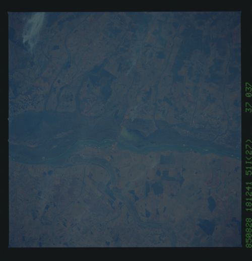
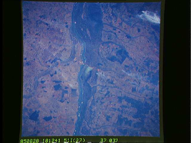
Image Caption: STS51I-37-0037 Paraná River, Brazil August 1985
This low-oblique, southwest-looking photograph shows a small portion of the Paraná River. The Paraná, 2485 miles (3999 kilometers) long, is the Western Hemisphere's third longest river. The Paranapanema River, 500 miles (805 kilometers) long, can be seen entering the Paraná from the east. Near the center of the photograph, partial construction of a new dam is discernible. Now completed, the dam holds the Pôrto Primavera Reservoir. Presently, the dark green vegetation in the floodplain of the Paraná is covered with water from the reservoir, which is used not only to generate electricity but also to irrigate the agricultural fields on either side of the river.
This low-oblique, southwest-looking photograph shows a small portion of the Paraná River. The Paraná, 2485 miles (3999 kilometers) long, is the Western Hemisphere's third longest river. The Paranapanema River, 500 miles (805 kilometers) long, can be seen entering the Paraná from the east. Near the center of the photograph, partial construction of a new dam is discernible. Now completed, the dam holds the Pôrto Primavera Reservoir. Presently, the dark green vegetation in the floodplain of the Paraná is covered with water from the reservoir, which is used not only to generate electricity but also to irrigate the agricultural fields on either side of the river.
