STS51G-46-78
| NASA Photo ID | STS51G-46-78 |
| Focal Length | 100mm |
| Date taken | 1985.06.19 |
| Time taken | 13:04:55 GMT |
Resolutions offered for this image:
3952 x 3958 pixels 639 x 639 pixels 5700 x 5900 pixels 500 x 518 pixels 640 x 480 pixels 659 x 649 pixels
3952 x 3958 pixels 639 x 639 pixels 5700 x 5900 pixels 500 x 518 pixels 640 x 480 pixels 659 x 649 pixels


Cloud masks available for this image:
Spacecraft nadir point: 20.7° S, 16.1° E
Photo center point: 17.9° S, 15.6° E
Photo center point by machine learning:
Photo center point: 17.9° S, 15.6° E
Photo center point by machine learning:
Nadir to Photo Center: North
Spacecraft Altitude: 194 nautical miles (359km)
Country or Geographic Name: | NAMIBIA |
Features: | ETOSHA PAN, OVAMBOLAND |
| Features Found Using Machine Learning: | |
Cloud Cover Percentage: | 0 (no clouds present) |
Sun Elevation Angle: | 36° |
Sun Azimuth: | 322° |
Camera: | Hasselblad |
Focal Length: | 100mm |
Camera Tilt: | 41 degrees |
Format: | 5017: Kodak, natural color positive, Ektachrome, X Professional, ASA 64, standard base |
Film Exposure: | Normal |
| Additional Information | |
| Width | Height | Annotated | Cropped | Purpose | Links |
|---|---|---|---|---|---|
| 3952 pixels | 3958 pixels | No | No | Earth From Space collection | Download Image |
| 639 pixels | 639 pixels | No | No | Earth From Space collection | Download Image |
| 5700 pixels | 5900 pixels | No | No | Download Image | |
| 500 pixels | 518 pixels | No | No | Download Image | |
| 640 pixels | 480 pixels | No | No | Download Image | |
| 659 pixels | 649 pixels | Download Image |
Download Packaged File
Download a Google Earth KML for this Image
View photo footprint information
Download a GeoTIFF for this photo
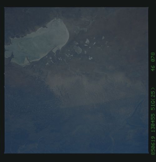
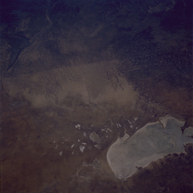
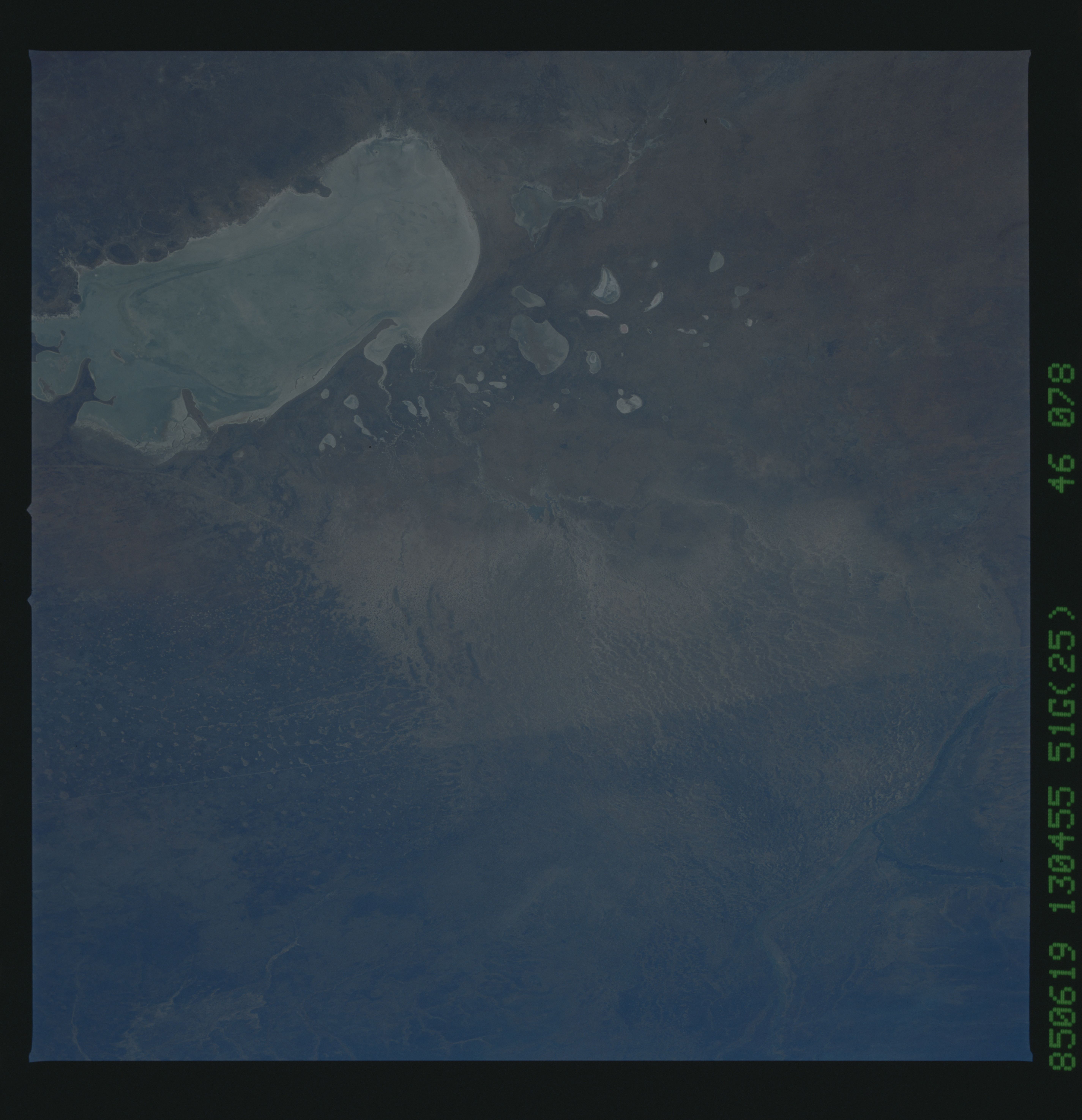
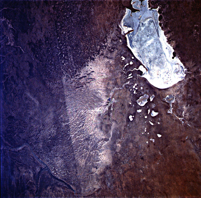
Image Caption: STS51G-046-0078 Etosha Pan, Namibia June 1985
Only occasionally are country boundaries easily observed from space. In this near-vertical photograph, the straight border between Angola (north) and Namibia (south) is clear. The major cause of this marked difference in terrain is that the two countries have different livestock grazing practices. Obviously, Namibia has allowed more grazing to take place; hence, there is less vegetation, resulting in highly reflective soil, which is recorded in this photograph. The large, relatively rectangular, and highly reflective landform in the southeastern part of the photograph is a dry lakebed known as the Etosha [salt] Pan. Notice that several highly reflective dry lakes lie to the northwest of the much larger Etosha Pan dry lake. In this semiarid environment, only on rare occasions is there any evidence of moisture or surface runoff into these dry lakebeds.
Only occasionally are country boundaries easily observed from space. In this near-vertical photograph, the straight border between Angola (north) and Namibia (south) is clear. The major cause of this marked difference in terrain is that the two countries have different livestock grazing practices. Obviously, Namibia has allowed more grazing to take place; hence, there is less vegetation, resulting in highly reflective soil, which is recorded in this photograph. The large, relatively rectangular, and highly reflective landform in the southeastern part of the photograph is a dry lakebed known as the Etosha [salt] Pan. Notice that several highly reflective dry lakes lie to the northwest of the much larger Etosha Pan dry lake. In this semiarid environment, only on rare occasions is there any evidence of moisture or surface runoff into these dry lakebeds.
