STS51F-36-59
| NASA Photo ID | STS51F-36-59 |
| Focal Length | 100mm |
| Date taken | 1985.08.06 |
| Time taken | 12:11:28 GMT |
Resolutions offered for this image:
3935 x 3887 pixels 639 x 632 pixels 5700 x 5900 pixels 500 x 518 pixels 640 x 480 pixels 2513 x 2514 pixels 2513 x 2514 pixels 4750 x 4722 pixels 512 x 490 pixels
3935 x 3887 pixels 639 x 632 pixels 5700 x 5900 pixels 500 x 518 pixels 640 x 480 pixels 2513 x 2514 pixels 2513 x 2514 pixels 4750 x 4722 pixels 512 x 490 pixels

Cloud masks available for this image:
Spacecraft nadir point: 49.5° N, 61.4° E
Photo center point: 45.5° N, 60.0° E
Photo center point by machine learning:
Photo center point: 45.5° N, 60.0° E
Photo center point by machine learning:
Nadir to Photo Center: South
Spacecraft Altitude: 178 nautical miles (330km)
Country or Geographic Name: | KAZAKHSTAN |
Features: | ARAL SEA |
| Features Found Using Machine Learning: | |
Cloud Cover Percentage: | 10 (1-10)% |
Sun Elevation Angle: | 30° |
Sun Azimuth: | 260° |
Camera: | Hasselblad |
Focal Length: | 100mm |
Camera Tilt: | Low Oblique |
Format: | 5017: Kodak, natural color positive, Ektachrome, X Professional, ASA 64, standard base |
Film Exposure: | Normal |
| Additional Information | |
| Width | Height | Annotated | Cropped | Purpose | Links |
|---|---|---|---|---|---|
| 3935 pixels | 3887 pixels | No | No | Earth From Space collection | Download Image |
| 639 pixels | 632 pixels | No | No | Earth From Space collection | Download Image |
| 5700 pixels | 5900 pixels | No | No | Download Image | |
| 500 pixels | 518 pixels | No | No | Download Image | |
| 640 pixels | 480 pixels | No | No | Download Image | |
| 2513 pixels | 2514 pixels | Download Image | |||
| 2513 pixels | 2514 pixels | Download Image | |||
| 4750 pixels | 4722 pixels | Download Image | |||
| 512 pixels | 490 pixels | Yes | No | Download Image |
Download Packaged File
Download a Google Earth KML for this Image
View photo footprint information
Download a GeoTIFF for this photo
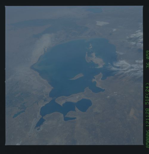
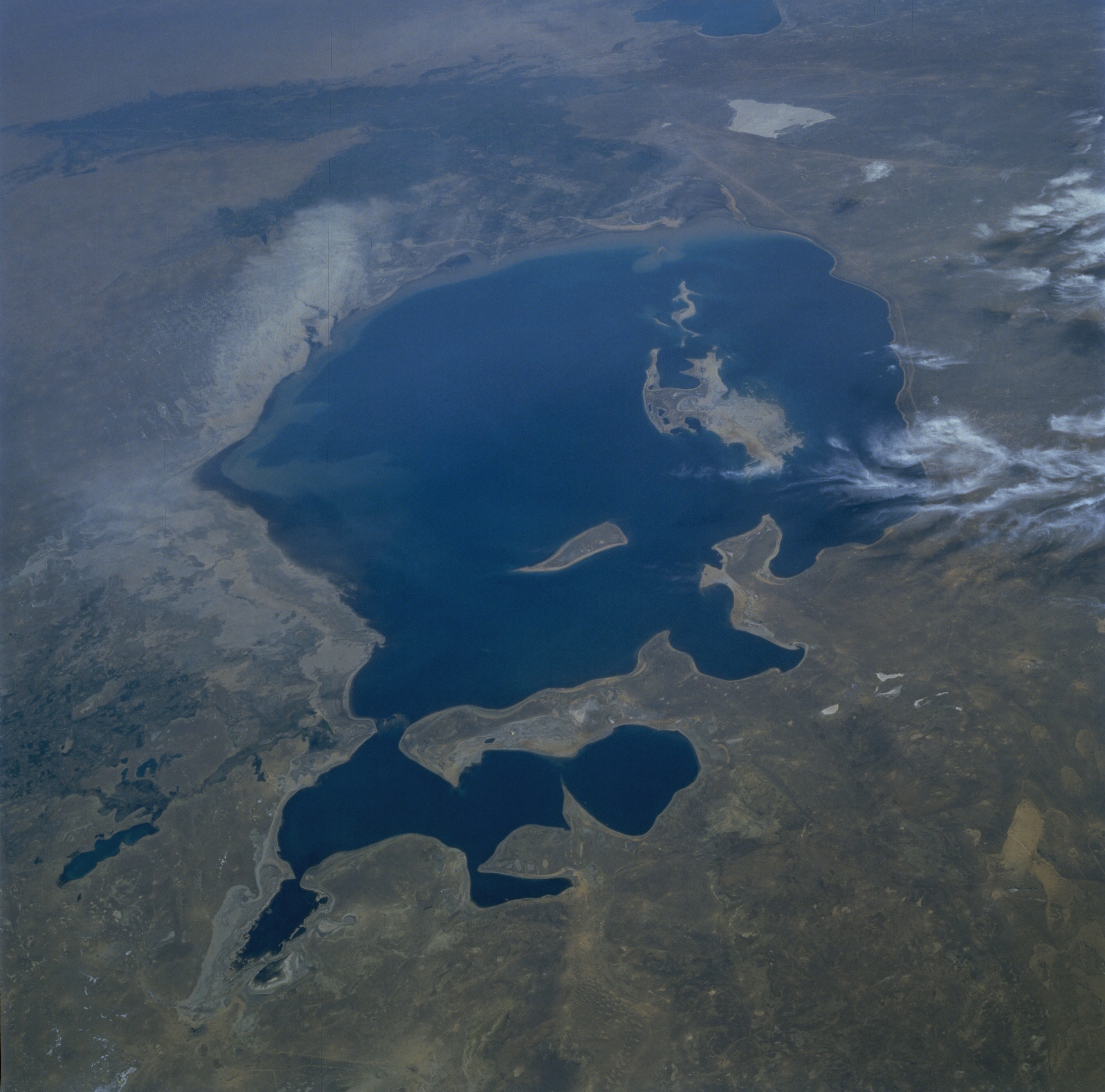
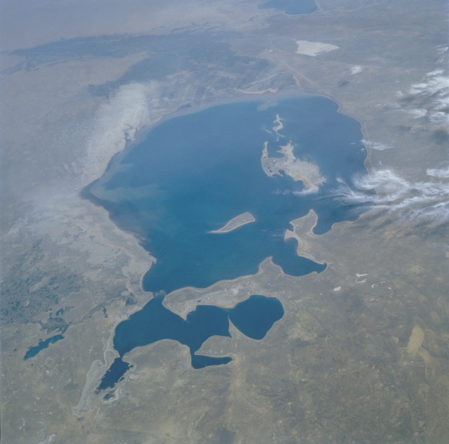
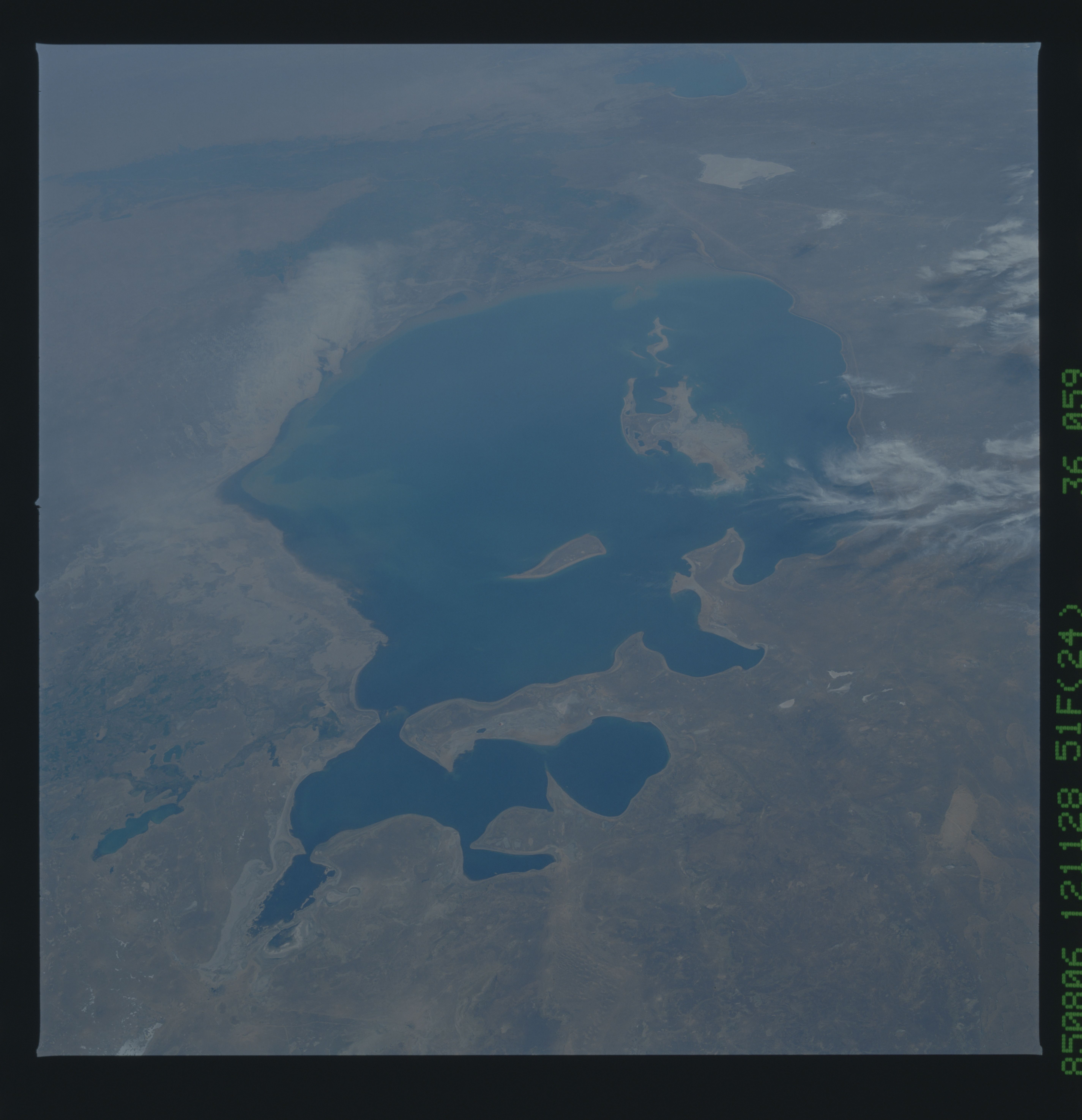
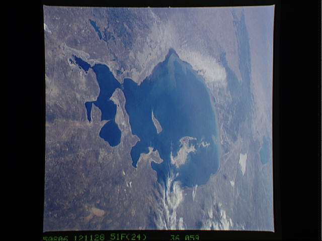
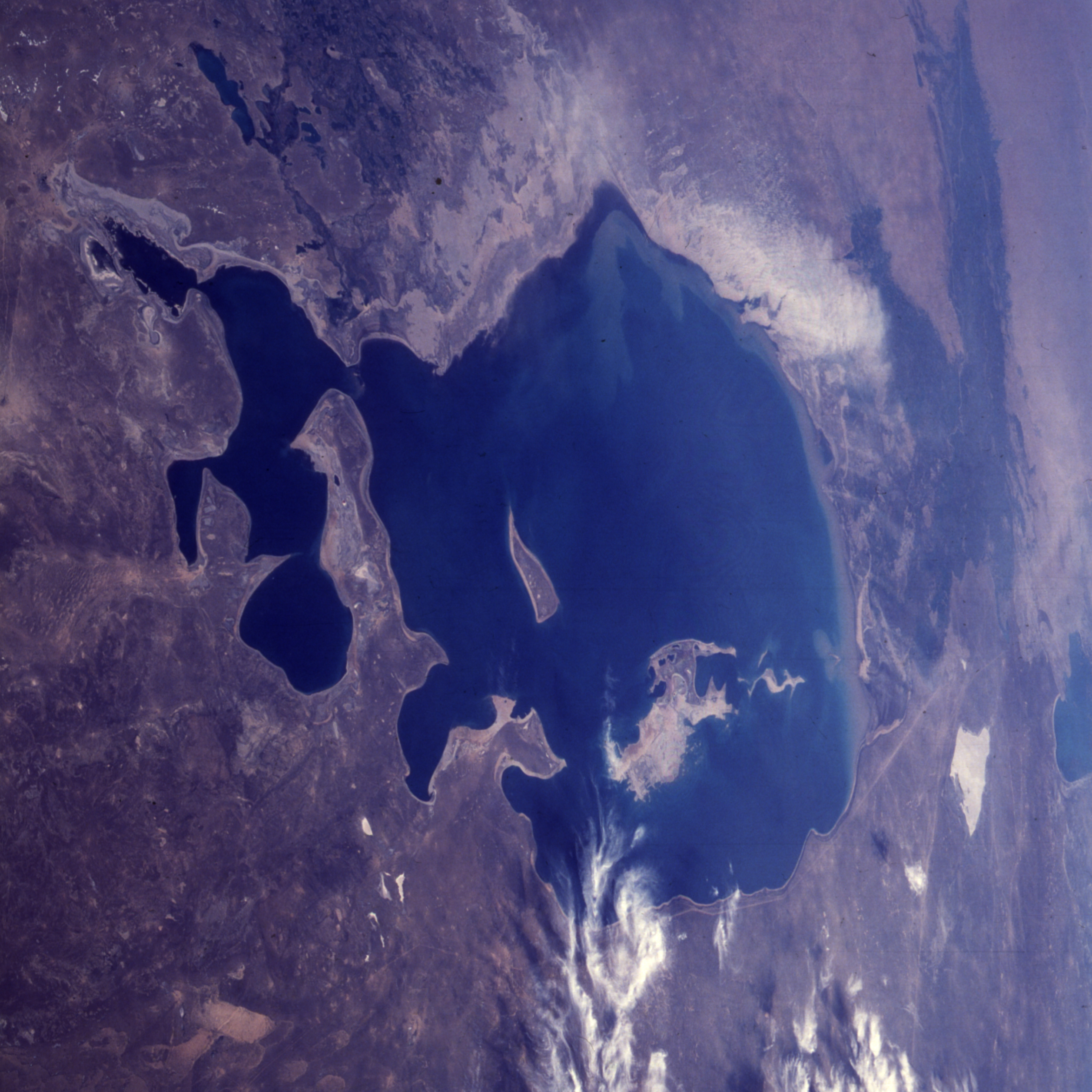
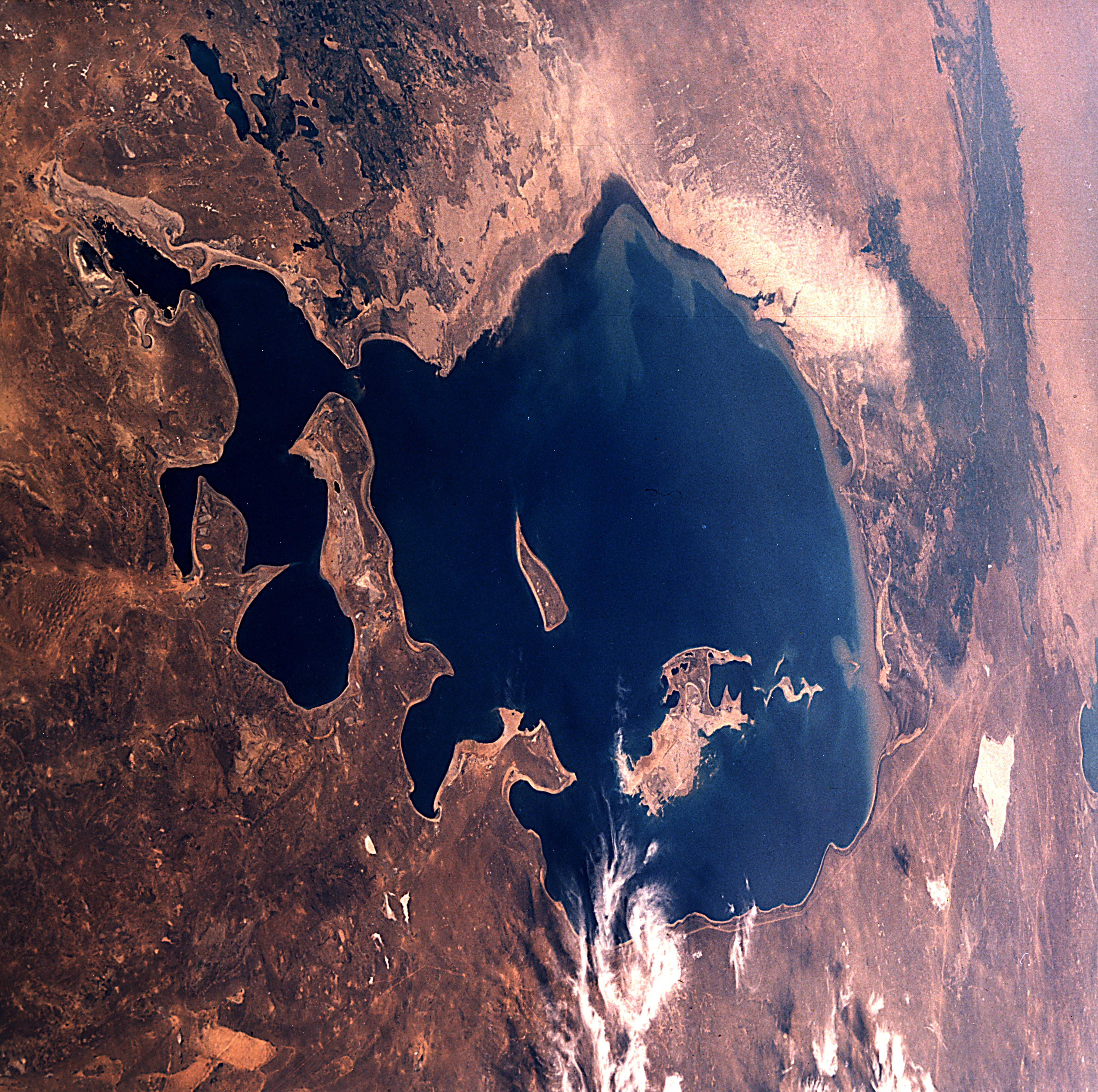
Image Caption: STS51F-36-59 Aral Sea, Kazakhstan and Uzbekistan July 1985
The Aral Sea, the fourth largest lake in the world, can be seen in this low-oblique, south-looking view. When this photograph was taken, the Aral Sea covered an area of approximately 26 000 square miles (67 000 square kilometers), was approximately 260 miles (420 kilometers) long, 175 miles (280 kilometers) wide, and had an average depth of 33 feet (10 meters) and a maximum depth of 220 feet (70 meters). Separated from the Caspian Sea millions of years ago and landlocked at the center of a broad basin, the Aral Sea is surrounded on all sides by desert or steppe. Although two major rivers feed the sea, the Amu Darya from the south and the Syr Darya from the northeast, there is no outlet. Before 1960, the sea was only slightly saline. The development of agricultural irrigation projects along both river courses in the late 1950s impeded the flow of water, and little or no fresh water reaches the sea now. With reduced quantities of fresh water and constant evaporation, the sea has become more saline and has shrunk drastically since the early 1960s. It has also become polluted with numerous pesticides and fertilizers. Two islands can be seen emerging from the Aral Sea. Barsa-Kel'mes Island is the pointed island in the north-central part of the sea; Vozrozhdeniya Island is the broad island in the west part of the sea. To the south, the darker colored, irrigated agricultural lands along the Amu Darya are visible. East of the sea near the shoreline, a duststorm (whitish area) of exposed sea bottom sediments can be seen moving southwestward toward the darker agricultural areas. Sea bottom sediments and past shorelines are visible (whitish-gray areas) along all parts of the sea and the emerging islands. (See STS047-079-083 for a comparison of how the Aral Sea has continued to shrink in only seven years.)
The Aral Sea, the fourth largest lake in the world, can be seen in this low-oblique, south-looking view. When this photograph was taken, the Aral Sea covered an area of approximately 26 000 square miles (67 000 square kilometers), was approximately 260 miles (420 kilometers) long, 175 miles (280 kilometers) wide, and had an average depth of 33 feet (10 meters) and a maximum depth of 220 feet (70 meters). Separated from the Caspian Sea millions of years ago and landlocked at the center of a broad basin, the Aral Sea is surrounded on all sides by desert or steppe. Although two major rivers feed the sea, the Amu Darya from the south and the Syr Darya from the northeast, there is no outlet. Before 1960, the sea was only slightly saline. The development of agricultural irrigation projects along both river courses in the late 1950s impeded the flow of water, and little or no fresh water reaches the sea now. With reduced quantities of fresh water and constant evaporation, the sea has become more saline and has shrunk drastically since the early 1960s. It has also become polluted with numerous pesticides and fertilizers. Two islands can be seen emerging from the Aral Sea. Barsa-Kel'mes Island is the pointed island in the north-central part of the sea; Vozrozhdeniya Island is the broad island in the west part of the sea. To the south, the darker colored, irrigated agricultural lands along the Amu Darya are visible. East of the sea near the shoreline, a duststorm (whitish area) of exposed sea bottom sediments can be seen moving southwestward toward the darker agricultural areas. Sea bottom sediments and past shorelines are visible (whitish-gray areas) along all parts of the sea and the emerging islands. (See STS047-079-083 for a comparison of how the Aral Sea has continued to shrink in only seven years.)
